Mejorada

Last updated
Mejorada, Spain
Bandera de Mejorada.svg
Escudo de Mejorada.svg
Country Spain
Autonomous community Castile-La Mancha
Province Toledo
Municipality Mejorada
Area
  Total46 km2 (18 sq mi)
Elevation
548 m (1,798 ft)
Population
 (2018) [1]
  Total1,265
  Density28/km2 (71/sq mi)
Time zone UTC+1 (CET)
  Summer (DST) UTC+2 (CEST)
Mejorada Town Hall Building Mejorada, Toledo, Espana, 2017 06.jpg
Mejorada Town Hall Building

Mejorada is a village located in the province of Toledo, Castile-La Mancha, Spain. According to the 2017 census (INE), the municipality has a population of 2,809 inhabitants.

Contents

Name

At the beginning the village was called 'Malpartida' (Badly distributed in Spanish) because of the trouble to fit it into the lands of Ávila, Oropesa or Talavera. In the 14th century, along with the expansion of its territories, the name Malpartida was finally changed for 'Mejorada' (Improved in Spanish) due to the improvements made on its territorial situation and to relieve the villagers who thought the previous name brought bad luck.

Location

Located 9 km north of Talavera de la Reina, the village is settled in the region of the 'Sierra de San Vicente', which is a subregion of Talavera. Mejorada adjoins Montesclarod to the North, Segurilla to the East, Talavera to the South and Velada to the West.

It is located in the area enclosed between the Tagus river and the Tiétar river, a place called 'El Berrocal'

The Guadyerbas River sets the northern frontier of the territory, and several streams, the largest being the Riolobos.

Main sights and monuments

The Castle

Mejorada holds the ruins of a castle placed around 250 meters (800 ft.) southeast of the village center.

It is supposed to have been built on the 13th century, linked to the creation of the Estate of Mejorada, when king Sancho IV of Castile gave the village to the knight Juan García de Toledo in July 1288, who would become the first Lord of Mejorada.

The fortress was built to enforce the lords of the village against the council of Talavera. The castle would then become the main symbol of the strength of nobility opposite the ecclesiastical power.

The castle is built on a 78 feet side square with rounded turrets on each corner. The main entrance is placed looking west, in which wall there is a great mid medieval rectangular keep. The masonry and brick walls are approximately 5 feet thick.

Nowadays the manor is in ruins, only lasting two walls and part of the other two.

Parish church of Nuestra Señora de la Asunción

The Church was made almost entirely of lime and stone which is very typical on the area, and dates back from the 15th century. It's devoted to Nuestra Señora de la Asunción (Our Lady of the Assumption).

It's a single nave with transept temple, with a two levels tower facing West, the chancel facing East and the main façade facing south. The ceiling is coffered with wooden beams in twos arranged slantwise creating the shape of the roof.

Watchover

The Watchtower is situated 2000 ft (600m) south from the city centre, on the summit of the Atalaya Hill at around 1900 ft (580m) high. The tower has a 5.5 ft (1.70m) circular floor-plan with a current height of 9.2 ft (2.80m) made of masonry and lime and sand mortar.

This Watchtower was part of an ensemble of lookout watchtowers along with the ones on Velada, El Casar, Segurilla, Cardiel, etc. built probably during the Islamic times and then reused by the Christians until the Middle Ages.

From the Watchtower you have full view of the valley made by the Tagus river to the South, and the Guadyerbas river to the North. You can also catch sight of the watchtowers at El Casar to the West and Segurilla to the East; and the Castle of Mejorada, which is around 1450 ft (540m) North.

Festivals

Related Research Articles

<span class="mw-page-title-main">Tagus</span> Longest river on the Iberian Peninsula

The Tagus is the longest river in the Iberian Peninsula. The river rises in the Montes Universales near Teruel, in mid-eastern Spain, flows 1,007 km (626 mi), generally west with two main south-westward sections, to empty into the Atlantic Ocean in Lisbon. Its drainage basin covers 80,100 km2 (30,927 sq mi) – exceeded in the peninsula only by the Douro. The river is highly used. Several dams and diversions supply drinking water to key population centres of central Spain and Portugal; dozens of hydroelectric stations create power. Between dams it follows a very constricted course, but after Almourol, Portugal it has a wide alluvial valley, prone to flooding. Its mouth is a large estuary culminating at the major port, and Portuguese capital, Lisbon.

<span class="mw-page-title-main">Castilla–La Mancha</span> Autonomous community of Spain

Castilla–La Mancha is an autonomous community of Spain. Comprising the provinces of Albacete, Ciudad Real, Cuenca, Guadalajara and Toledo, it was created in 1982. The government headquarters are in Toledo, and its largest city is Albacete.

<span class="mw-page-title-main">Province of Toledo</span> Province of Spain

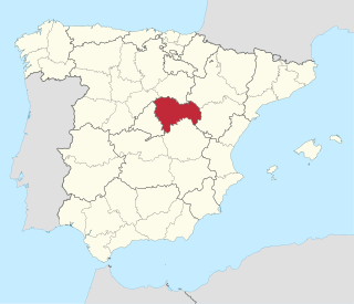
Toledo is a province of central Spain, in the western part of the autonomous community of Castile–La Mancha. It is bordered by the provinces of Madrid, Cuenca, Ciudad Real, Badajoz, Cáceres, and Ávila. Its capital is the city of Toledo.

<span class="mw-page-title-main">Province of Guadalajara</span> Province of Spain

Guadalajara is a province of Spain, belonging to the autonomous community of Castilla–La Mancha. As of 2019 it had a population of 258,890 people. The population of the province has grown in the last 10 years. It is located in the centre of the Iberian Peninsula.

<span class="mw-page-title-main">Battle of Talavera</span> 1809 battle of the Peninsular War

The Battle of Talavera was fought just outside the town of Talavera de la Reina, Spain some 120 kilometres (75 mi) southwest of Madrid, during the Peninsular War. At Talavera, a British army under Sir Arthur Wellesley combined with a Spanish army under General Cuesta in operations against French-occupied Madrid. The French army withdrew at night after several of its attacks had been repulsed.

<span class="mw-page-title-main">Talavera de la Reina</span> Municipality in Castile-La Mancha, Spain

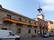
Talavera de la Reina is a city and municipality of Spain, part of the autonomous community of Castile–La Mancha. Its population of 83,303 makes it the second most populated municipality of the province of Toledo and the fourth largest in the region.

<span class="mw-page-title-main">Monfragüe</span>

Monfragüe is a Spanish national park noted for its bird-life. It is situated in the center of a triangle formed by Plasencia, Trujillo and the city of Cáceres within the province of Cáceres. Monfragüe is also a comarca of Extremadura, western Spain.

<span class="mw-page-title-main">Battle of Alarcos</span> 1195 battle of Almohads and Castillians

Battle of Alarcos, was a battle between the Almohads led by Abu Yusuf Ya'qub al-Mansur and King Alfonso VIII of Castile. It resulted in the defeat of the Castilian forces and their subsequent retreat to Toledo, whereas the Almohads reconquered Trujillo, Montánchez, and Talavera.

<span class="mw-page-title-main">Castle of Gormaz</span> Historic site in Spain

The Castle of Gormaz is a large castle located in Gormaz, Spain. Its current structure was built in 965 to defend the borders of the Caliphate of Cordoba. At the time of its construction, it was the largest fortress in Europe.

<span class="mw-page-title-main">Gamonal</span> Place in Castile-La Mancha, Spain

Gamonal is a little Spanish village, situated in the municipality of Talavera de la Reina.

<span class="mw-page-title-main">Alameda de la Sagra</span> Municipality in Castile-La Mancha, Spain

Alameda de la Sagra is a municipality located in the province of Toledo, Castile-La Mancha, Spain. According to the 2008 census (INE), the municipality has a population of 3324 inhabitants.

<span class="mw-page-title-main">El Puente del Arzobispo</span> Municipality in Castilla–La Mancha, Spain

El Puente del Arzobispo is a municipality of Spain located in the province of Toledo, Castilla–La Mancha. The municipality spans across a total area of 0.98 km2 and, as of 1 January 2020, it has a registered population of 1,225. Together with neighbouring Talavera de la Reina, El Puente del Arzobispo was a producing centre of Maiolica pottery in Early-Modern Spain.

<span class="mw-page-title-main">Segurilla</span> Municipality in Castile-La Mancha, Spain

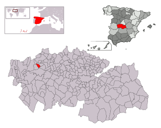
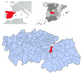
Segurilla is a municipality located in the province of Toledo, Castile-La Mancha, Spain. According to the 2017 census (INE), the municipality has a population of 1,345 inhabitants. It is located 9 km north of Talavera de la Reina, the second largest town of the Province of Toledo

Valdeverdeja is a municipality located in the province of Toledo, Castile-La Mancha, Spain. It belongs to the Campana de Oropesa region and has 647 inhabitants according to the 2006 census (INE). The municipal area is 67 km², and it has a population density of 10.04 inhabitants per km².

<span class="mw-page-title-main">Battle of Almaraz</span> 1812 battle during the Peninsular War

The Battle of Almaraz was a battle of the Peninsular War which took place on 18–19 May 1812, in which the Anglo-Portuguese Army under Lord Hill destroyed a French pontoon bridge across the River Tagus, in Almaraz, Spain. The bridge was protected by two French garrisons at either end.

<span class="mw-page-title-main">Juan de Talavera</span>

Juan de Talavera was a Spanish architect, sculptor and carver, member of the "Toledo School of Architecture", and architect of Queen Isabella I of Castile. Probably his father was also named Juan de Talavera, and he was a nephew of Andrés de Talavera, both working in the Cathedral of Seville circa 1450. Juan de Talavera married Maria Gutierrez, daughter of Egas Coeman or Egas of Brussels and he was probably also a nephew of Juan Guas by his wife.

<span class="mw-page-title-main">Defensive towers of Cantabria</span>

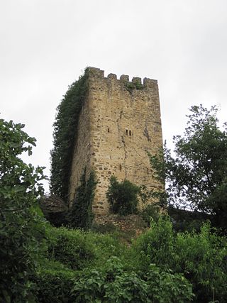
In Cantabria, there is a big number of fortified towers that fulfilled functions of housing and defense. These buildings, generally battlements, were erected mostly between the 13th and 15th centuries by noble families and influenced significantly in the architecture of Cantabria, passing some to be forts-houses, prelude to the future casona montañesa. A curious fact is that there are not in the region circular towers, as yes happens in the neighboring community of Asturias. Currently of the towers that survives several are in a deplorable condition.

<span class="mw-page-title-main">Walls of Madrid</span> Series of walls built around the city of Madrid, Spain

The Walls of Madrid are the five successive sets of walls that surrounded the city of Madrid from the Middle Ages until the end of the 19th century. Some of the walls had a defensive or military function, while others made it easy to tax goods entering the city. Towards the end of the 19th century the demographic explosion that came with the Industrial Revolution prompted urban expansion throughout Spain. Older walls were torn down to enable the expansion of the city under the grid plan of Carlos María de Castro.

<span class="mw-page-title-main">Muslim Walls of Madrid</span> Cultural property in Madrid, Spain

The Muslim Walls of Madrid, of which some vestiges remain, are located in the Spanish city of Madrid. They are probably the oldest construction extant in the city. They were built in the 9th century, during the Muslim domination of the Iberian Peninsula, on a promontory next to Manzanares river. They were part of a fortress around which developed the urban nucleus of Madrid. They were declared an Artistic-Historic Monument in 1954.

El Casar de Talavera is a EATIM and village belonging to the municipality of Talavera de la Reina, province of Toledo, Castilla–La Mancha, Spain.

References

  1. Municipal Register of Spain 2018. National Statistics Institute.

Coordinates: 40°01′N4°53′W / 40.017°N 4.883°W / 40.017; -4.883