Los Navalucillos

Last updated
Los Navalucillos
Los Navalucillos, vista general 3.jpg
Los Navalucillos Spain.svg
Escudo de Navalucillos.svg
Country Spain
Autonomous community Castile-La Mancha
Province Toledo
Municipality Los Navalucillos
Area
  Total356 km2 (137 sq mi)
Elevation
740 m (2,430 ft)
Population
 (2018) [1]
  Total2,171
  Density6.1/km2 (16/sq mi)
Time zone UTC+1 (CET)
  Summer (DST) UTC+2 (CEST)

Los Navalucillos is a municipality located in the province of Toledo, Castile-La Mancha, Spain. According to the 2018 census (INE), the municipality has a population of 2171 inhabitants.

Navalucillosplaza.JPG
Navalucillos Main Square

History

Tomb in Los Navalucillos Los Navalucillos, tumba 2.jpg
Tomb in Los Navalucillos

Several cave tombs have been found from the Muslim era that evoke Mozarabic rites. It seems that the foundation of the town took place in the first half of the 14th century, although it appears for the first time, as Naualuciellos, in a document dated February 5, 1209. In said document Alfonso VIII donates to Alfonso Téllez the town of Montalbán with its corresponding terms: Template:Citatioe In another document dated May 26, 1357, where Pedro I granted the lordship of Valdepusa to Diego Gómez, senior notary, it appears as Nava luezillos :

«... give us justice in the Valdepusa lordship, Talauera district that starts from the Alcachal fasta in the Tajo river, as well as part with Mal pyca and with Montaluán and with Nava luezillos ...».

Pedro I of Castile, May 26, 1357. [2]

In 1492, with the expulsion of the Jews, many of them settled in these lands, leaving as a legacy some customs that are preserved to this day.

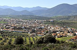
Between the 15th century and the 17th century, Los Navalucillos led the region economically, receiving migration mainly from neighboring Extremadura.

The moment of greatest splendor of the town was the 18th century whose ecclesiastical union, achieved by Cardinal Lorenzana, was seconded by an administrative union of the two Navalucillos, Navalucillos de Talavera de la Reina and Navalucillos from Toledo.

In the middle of the 19th century it had 500 houses and the municipal budget amounted to 25,590 reals. [3] At that time there was a iron foundry established by José Safont in the Mazo area next to the Pusa River. The factory was supplied with extractions from "los arrumbales, los acebales, crags de Juan Antón, de la Ermita y de los Lagares", [3] in the municipality of Los Navalucillos, and from the mines of Herrera in Los Navalmorales.

The town experienced its greatest demographic increase in the 1950s, with a population of approximately 7000 inhabitants.

Currently, Los Navalucillos tries to return to those moments of splendor, promoting activities oriented to rural tourism, or the expansion of the Cabañeros National Park at the end of the 2000s.

Related Research Articles

<span class="mw-page-title-main">Illán de Vacas</span> Municipality in Castilla–La Mancha, Spain

Illán de Vacas is a town in the province of Toledo, in Castile–La Mancha, Spain. The surface area of the municipality is 9 km², it has a total population of 1 inhabitant, making it the least populated municipality in Spain.

<span class="mw-page-title-main">Talavera de la Reina</span> Municipality in Castile-La Mancha, Spain

Talavera de la Reina is a city and municipality of Spain, part of the autonomous community of Castile–La Mancha. Its population of 83,303 makes it the second most populated municipality of the province of Toledo and the fourth largest in the region.

Jaun Zuria is the mythical first Lord and founder of the Lordship of Biscay, who defeated the Leonese and Asturian troops in the also-mythical Battle of Padura, in which he chased off the invaders to the Malato Tree, establishing there the borders of Biscay. There are three accounts of its legend, one by the Portuguese count Pedro Barcelos and two by the chronicler Lope García de Salazar. According to the legend, Jaun Zuria had been born from a Scottish or English princess who had been visited by the Basque deity Sugaar in the village of Mundaka.

Olivares is a city located in the Province of Seville, Spain. According to the 2016 census (INE), the city has a population of 9480 inhabitants. It is located in the Aljarafe, the comarca downstream of the Guadalquivir and west of Seville. It borders Albaida to the west, Gerena to the north, Salteras to the east, and Sanlúcar la Mayor and Villanueva del Ariscal to the south. After the establishment of the House of Olivares, it grew in size and influence, becoming an important urban center in the Aljarafe.

<span class="mw-page-title-main">Hontalbilla</span> Municipality in Castile and León, Spain

Hontalbilla is a municipality located in the province of Segovia, Castile and León, Spain. According to the 2004 census (INE), the municipality has a population of 391 inhabitants.

<span class="mw-page-title-main">Mora, Spain</span> Place in Castile-La Mancha, Spain

Mora is a town and municipality in Toledo province, in the autonomous community of Castile-La Mancha, Spain. The area is most famous for the abandoned ruins of the San Marcos de Yegros monastery of the Order of Santiago, located northeast of the town of Mora about 10 km on the Calle de los Dolores in the village of Paraje de Yegros.

Alarcia is a town of northern Spain, Autonomous Community of Castile and León, province of Burgos, Shire of Montes de Oca, sub-shire of Tirón-Rioja Burgalesa, in the municipality of Rábanos. It lies between the reservoir Úzquiza (west) and the peak of San Millan in the Sierra de la Demanda (southeast).

<span class="mw-page-title-main">Merades</span>

Merades is an ancient abandoned village located in the Montsià comarca, Catalonia, Spain.

<span class="mw-page-title-main">La Jara (comarca)</span> Comarca in Castile-La Mancha, Spain

La Jara is a comarca located in the Montes de Toledo at the western end of Toledo Province, it also includes the municipality of Anchuras, an enclave of the province of Ciudad Real, in Castile-La Mancha, Spain. The comarca's capital is Los Navalucillos, however Talavera de la Reina is an important city for local people in La Jara owing to historical ties, even though it is located outside of the comarca.

<span class="mw-page-title-main">Foronda</span> Village in Basque country, Spain

Foronda is a town and council belonging to the municipality of Vitoria, in the province of Álava. It is located at an altitude of 517 meters, bathed by the Zalla River. In basque: Oro-ondoa.

<span class="mw-page-title-main">Aguilar del Río Alhama</span> Municipality in La Rioja, Spain

Aguilar del Río Alhama is a village in the province and autonomous community of La Rioja, Spain. The municipality covers an area of 54.11 square kilometres (20.89 sq mi) and as of 2011 had a population of 549 people. It is located in a low altitude mountainous area, in the foothills of the Iberian System. It belongs to the region of Rioja Baja and is washed by the waters of the Alhama river.

<span class="mw-page-title-main">Senterada</span> Municipality in Catalonia, Spain

Senterada is a village in the province of Lleida and autonomous community of Catalonia, Spain. The municipality includes a small exclave to the north.

<span class="mw-page-title-main">Aqueduct of Algeciras</span> Bridge in Algeciras, Spain

The Aqueduct of Algeciras is one of the most important buildings in Algeciras, Spain. Numerous textbooks, dictionaries and guidebooks cite this building as Arabic or Roman but it was built in the eighteenth century.

<span class="mw-page-title-main">Siege of Algeciras (1369)</span>

The siege of Algeciras (1369) was undertaken during the period of the Reconquest of Spain by Muhammed V, Sultan of Granada to reclaim the city of Al-Hadra Al-Yazirat, called Algeciras by the Christians, in the Kingdom of Castile. The siege lasted just three days, and the sultan was victorious. The Muslims thus regained a major city which had been in Castilian hands since Alfonso XI of Castile took it from the Moroccans after the long 1342–1344 siege. Ten years after the capture of the city, in 1379 the sultan of Granada decided to completely destroy the city to prevent it falling into Christian hands. It was impossible to defend the place at a time when the Muslim kings of the Iberian Peninsula had lost much of military power they enjoyed in earlier centuries.

The following is a timeline of the history of the city of Jerez de la Frontera, Spain.

<span class="mw-page-title-main">Amorós</span> Locality in Catalonia, Spain

Amorós is a locality belonging to the municipality of Sant Guim de Freixenet, in the Province of Lleida, Catalonia, Spain. As of 2020, it has a population of 12. A standalone municipality in the past, it was absorbed by the municipality of Sant Guim de Freixenet in between 1842 and 1857. The Madoz dictionary described its location as lying "on a plain with free ventilation and a healthy climate".

<span class="mw-page-title-main">Turieno</span>

Turieno is a town in the municipality of Camaleño.

<span class="mw-page-title-main">Argüébanes</span>

Argüébanes is a town in the municipality of Camaleño.

Isín is a locality belonging to the municipality of Sabiñánigo. In 2019, it had a population of 5 inhabitants. The populated place lies in the valley formed by the Aurín river, on its right bank, at about 1027 metres above sea level.

<i>Diccionario geográfico-estadístico-histórico de España y sus posesiones de Ultramar</i> Geographic handbook of Spain

The Diccionario geográfico-estadístico-histórico de España y sus posesiones de Ultramar is a geographic handbook of Spain. Originally published in 16 volumes between 1845 and 1850, it was edited and directed by Pascual Madoz. A widely known work in Spain, used as reference work, it stands out in terms of the sheer amount of information, its systematization as well as for covering the whole geography of Spain.

References

  1. Municipal Register of Spain 2018. National Statistics Institute.
  2. Talavera de la Reina Municipal Archives, doc. 12, leg. 50.
  3. 1 2 Madoz, Pascual (1850). Diccionario geográfico-estadístico-histórico de España y sus posesiones de Ultramar . tomo IX. Madrid: Imprenta del Diccionario geográfico-estadístico-histórico de D. Pascual Madoz. pp.  -.

Coordinates: 39°40′N4°38′W / 39.667°N 4.633°W / 39.667; -4.633