
This article is about transport in Belarus.

Bosnia and Herzegovina has facilities for road, rail and air transport. There are five international road routes and 20 state highways, with bus connections to many countries. Railways total just over 1,000 km with links to Croatia and Serbia. There are 25 airports, seven of them with paved runways. The Sava River is navigable, but its use is limited.
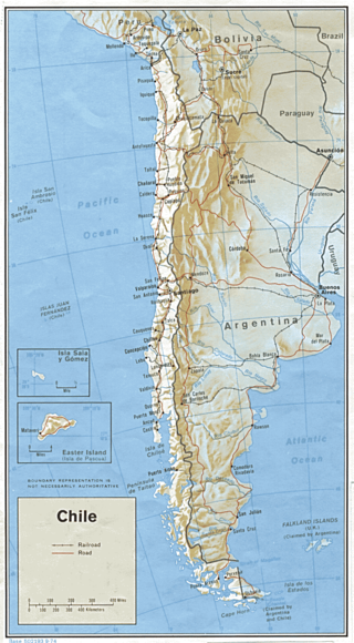
Transport in Chile is mostly by road. The far south of the country is not directly connected to central Chile by road without travelling through Argentina, and water transport also plays a part there. The railways were historically important in Chile, but now play a relatively small part in the country's transport system. Because of the country's geography and long distances between major cities, aviation is also important.
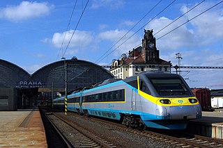
Transport in the Czech Republic relies on several main modes, including transport by road, rail, water and air.

Transport in the Dominican Republic utilizes a system of roads, airports, ports, harbours, and an urban railway.
Transportation in Ecuador is the transport infrastructure networks in Ecuador and those connecting the country with other countries. Transportation in Ecuador include aviation, highways, pipelines, ports and harbors, railways and waterways. Apart from transporting passengers, the country is a relatively small exporter of fruits and vegetables such as banana, papayas and pineapples.
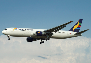
Transport in Eritrea includes highways, airports and seaports, in addition to various forms of public and private vehicular, maritime and aerial transportation.
Modes of transport in Fiji include rail, road, water, and air. The rail network is mainly used for movement of sugar cane. Suva and Lautoka are the largest seaports. There are 122 km of navigable inland waterways. There are two international airports, one other paved airport, and over 20 with unpaved runways. With 333 tropical islands that make up this country, one can expect to use various modes of transport to get to their destination.
Modes of transport in Gabon include rail, road, water, and air. The one rail link, the Trans-Gabon Railway, connects the port of Owendo with the inland town of Franceville. While most of the country is connected by roads, not all areas are accessible. Much of the road network remains unpaved, and it primarily revolves around seven "national routes" labeled N1 through N7. The largest seaports are Port-Gentil and the newer Owendo, and 1,600 km of inland waterways are navigable. There are three international airports, eight other paved airports, and over 40 with unpaved runways. Nearly 300 km of pipelines carry petroleum products, mainly crude oil.
For Soviet transportation, see Transport in the Soviet Union.
Transportation in Guatemala includes roads, waterways, airports and a short cross-border rail line from Mexico.

Transport in Guinea is composed by a variety of systems that people in the country use to get around as well as to and from domestic and international destinations. The railway from Conakry to Kankan ceased operating in the mid-1980s. Most vehicles in Guinea are 20+ years old, and cabs are any four-door vehicle which the owner has designated as being for hire. Domestic air services are intermittent. Conakry International Airport is the largest airport in the country, with flights to other cities in Africa as well as to Europe.
Transport in Honduras refers to transport in Honduras, a country in Central America.

Transport in Liberia consist of 266 miles of railways, 6,580 miles of highways, seaports, 29 airports and 2 miles of pipeline for oil transportation. Busses and taxis are the main forms of ground transportation in and around Monrovia. Charter boats are also available.
This article describes the transport in Peru.

Transport in Spain is characterised by a network of roads, railways, trams, air routes, and ports. Its geographic location makes it an important link between Europe, Africa, and the Americas. Major forms of transit generally radiate from the capital, Madrid, located in the centre of the country, to link with the capitals of the autonomous communities.
The transport network in Uruguay consists of 1,673 km of rail network, 7,743 km of paved roads, 1,600 km of navigable waterways, and 11 airports with paved roads.

Vanuatu's undeveloped road system, with fewer than 100 miles of paved roads, consists mostly of dirt tracks suitable only for four-wheel-drive vehicles. Every island has one or two short airstrips where Vanair’s Twin Otter planes land two or three times weekly. In addition, every island has a small port or wharf where small cargo ships and boats regularly dock.
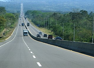
Transport in Venezuela revolves around a system of highways and airports. Venezuela is connected to the world primarily via air and sea. In the south and east the Amazon rainforest region has limited cross-border transport; in the west, there is a mountainous border of over 1,375 miles (2,213 km) shared with Colombia. The Orinoco River is navigable by oceangoing vessels up to 400 km inland, and connects the major industrial city of Ciudad Guayana to the Atlantic Ocean.


