Apopa

Last updated
Apopa
Apopa El Salvador Cathedral 2012.jpg
Santa Catarina Cathedral
Bandera apopa el salvador.png
El Salvador location map.svg
Red pog.svg
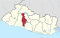
Apopa
Location in El Salvador
Coordinates: 13°48′N89°11′W / 13.800°N 89.183°W / 13.800; -89.183
Country Flag of El Salvador.svg El Salvador
Department San Salvador Department
Metro San Salvador Metropolitan Area
Incorporated (town)1874
Incorporated (city)1921
Government
  TypeDemocratic Republic
  MayorJennifer Juárez
Area
  City20.02 sq mi (51.84 km2)
Population
 (2020)
  City198,528
   Urban
198,528
Time zone UTC−6 (Central Standard Time)
SV-SS
CP 1123
Area code +503
Website alcaldiadeapopa.com (in Spanish)

Apopa is a municipality in the San Salvador department of El Salvador. Probably the seventh biggest city in El Salvador with a little more than 150,000 people, the city has now collided with Soyapango and San Salvador, making it part of the San Salvador metropolitan area (with a 1,900,000 2010 population estimate).

Contents

Toponymy

The toponym Apopa means "a place with mist". lugar de vapores de agua.[ citation needed ]

Geography

Hydography: The rivers crossing this municipality are Acelhuate, Las Cañas, Guaycume and Tomayate river.

Dimensions: The area is 51.84 km2

Orography: The hills within this municipality are El Sartén and El Guaycume hills.

History

Streets of Apopa in 1990, photographed by Linda Hess Miller Apopa 1990 11.jpg
Streets of Apopa in 1990, photographed by Linda Hess Miller

The people of Apopa, were a part of the department of San Salvador from June 12, 1824, until March 9, 1836, when it transferred to the federal district of the Central American Federation until June 30, 1839, when it again returned to a municipality of the northern district of San Salvador with the dissolution of the Central American Federation.

As a municipality, Apopa by November 14, 1860, had a population of 2194. Its jurisdiction included three farms: The Angel Arrasola, San José and San Nicolás. The latter purchased by the Municipal Corporation. To cooperate in their acquisition, the General President of the Republic Don Gerardo Barrios by act of January 28, 1865, made Apopa head of the northern district with jurisdiction over San Martin, Nejapan and Tonacatepeque. On March 7, 1874, during the administration of Field Marshal Don Santiago Gonzales Apopa was awarded the title of Villa Apopa. In 1878 the district increased with the incorporation of the municipality of El Paisnal. In 1892 Apopa stopped being head of the former district and became part of the new district Tonacatepeque. On June 7, 1921, during the administration of Jorge Meléndez Apopa was conferred the title of the city of Villa Apopa.

Sports

The local professional football club is named C.D. Vendaval Apopa and it currently plays in the Salvadoran Second Division after they merged with Chalatenango.

Related Research Articles

<span class="mw-page-title-main">San Salvador</span> Capital of El Salvador

San Salvador is the capital and the largest city of El Salvador and its eponymous department. It is however the country's largest agglomeration. It is the country's political, cultural, educational and financial center. The Municipality of San Salvador has 525,990 inhabitants (2024). The Metropolitan Area of San Salvador, which comprises the capital itself and 13 of its municipalities, has a population of 2,404,097. The urban area of San Salvador has a population of 1,600,000 inhabitants.

<span class="mw-page-title-main">Santa Ana, El Salvador</span> Municipality in El Salvador

Santa Ana is the second largest city in El Salvador, after the capital of San Salvador. It is located 64 kilometers northwest of San Salvador, the capital city. Santa Ana has approximately 277,264 (2020) inhabitants and serves both as the capital of the department of Santa Ana and as the municipal seat for the surrounding municipality of the same name. For its administration the municipality is divided into 35 colonias (neighborhoods) and 318 small villages.

<span class="mw-page-title-main">San Cristóbal Province</span> Province of the Dominican Republic

San Cristóbal is a province in the southern region of Dominican Republic, located west of the capital Santo Domingo. With approximately 642,000 inhabitants, it is the fourth most populated province in the country, only behind Santo Domingo, Santiago and the National District. It borders the provinces Monseñor Nouel (north), Monte Plata (northeast), Santo Domingo (east), Peravia (west) and San José de Ocoa (northwest). The Caribbean Sea borders the province to the south. The provincial capital is the city of San Cristóbal.

<span class="mw-page-title-main">San Salvador Department</span> Department of El Salvador

San Salvador is a department of El Salvador in the west central part of the country. The capital is San Salvador, which is also the national capital. The department has North of the Rio Lempa Valley, the "Valle de las Hamacas" and a section of Lake Ilopango. Some of the department's cities that are densely populated are: San Salvador, Ciudad Delgado, Mejicanos, Soyapango, Panchimalco and Apopa. The department covers an area of 886.2 square kilometres (342.2 sq mi) and the last census count in 2017 reported 2,404,097 people. It was classified as a department on June 12, 1824. During the time of the colony, the department was the San Salvador Party, from where territory was taken to make the departments of Chalatenago, La Libertad, Cuscatlán and La Paz. This department produces beans, coffee, sugar cane, etc. for agriculture, on the other hand San Salvador Department holds many headquarters for banking companies in El Salvador and Central America, and for many communication services, also the headquarters of the electric companies are located in the San Salvador Department, last years these companies took a step and started exporting electricity to all Central America. The current mayor of the department is Ernesto Muyshondt (2015–2019)

<span class="mw-page-title-main">Sonsonate Department</span> Department of El Salvador

Sonsonate is a department of El Salvador in the western part of the country. The capital is Sonsonate.

<span class="mw-page-title-main">Estelí</span> Municipality in Estelí Department, Nicaragua

Estelí, officially Villa de San Antonio de Pavia de Estelí is a city and municipality within the Estelí department. It is the 8th largest city in Nicaragua due to the high urbanization of its municipality, at 84.8%, with an urban population of 111,244. It is also the 8th largest municipality, and an active commercial center in the north, known as "the Diamond of the Segovia" and the de facto capital of the north.

<span class="mw-page-title-main">Concepción Batres</span> Municipality in the Usulután department of El Salvador

Concepción Batres is a municipality in the Usulután department of El Salvador.It is bordered to the north by El Tránsito and Ereguayquín; to the east by El Tránsito and Jucuarán; to the south by Usulután and to the west by Ereguayquín and Usulután.

<span class="mw-page-title-main">Ayutuxtepeque</span> Municipality in San Salvador, El Salvador

Ayutuxtepeque is a municipality in the San Salvador department of El Salvador. It is one of the nine municipalities that make up the San Salvador Metropolitan Area (AMSS). The name of the municipality means "Armadillos Hill(or Mountain)"

<span class="mw-page-title-main">San Martín, El Salvador</span> Municipality in San Salvador Department, El Salvador

San Martín is a municipality in the San Salvador department of El Salvador. According to the 2007 Population and Housing Census, it has 72,758 inhabitants. The municipality is limited by San José Guayabal and Oratorio de Concepción to the North; San Bartolomé Perulapía and San Pedro Perulapán to the East; by Ilopango and the Lake of Ilopango to the South; and to the West by Tonacatepeque. For its administration it is divided into 8 cantons and 37 hamlets. Its main river is the Chunchucuyo; in terms of its orographyits main elevations are Las Delicias, Chuchutepeque, La Tigra and Teguantepeque hills. Its climate is warm and belongs to the type of hot earth and its annual rainfall amount varies between 1,750 and 1970 mm. The vegetation is constituted by humid subtropical forest. The locality covers an area of 55.8 km2 and the headland has an elevation of 725.0 meters above sea level. The municipality is part of the San Salvador metropolitan area.

Tonacatepeque is a municipality in the San Salvador department of El Salvador. It has a population of 90,896 inhabitants according to the 2007 Census. This makes this municipality twelfth largest in terms of population in El Salvador. It is part of the San Salvador metropolitan area.

<span class="mw-page-title-main">Soyapango</span> Municipality in San Salvador Department, El Salvador

Soyapango is a municipality in the San Salvador department of El Salvador. Soyapango is the country's largest municipality with 284,700 residents. Soyapango is a satellite city of San Salvador and it is the main thoroughfare between San Salvador and the eastern part of the country, and nearly 70,000 vehicles travel through it every day. The nickname for this satellite city is Soya.

<span class="mw-page-title-main">San Pedro Nonualco</span> District in La Paz, El Salvador

San Pedro Nonualco is a District in the La Paz department of El Salvador. located in the paracentral region of the country, near the banks of the Jiboa River. The district has a territorial area of 27.5 km² and a population of 12,000 inhabitants. The municipality includes an urban area divided into 6 neighborhoods, as well as 7 rural cantons.

<span class="mw-page-title-main">Itagüí</span> Municipality and city in Antioquia Department, Colombia

Itagüí is a city and municipality of Colombia, located in the south of the Aburrá Valley in the Antioquia Department. It is part of the Metropolitan Area of the Aburrá Valley.

<span class="mw-page-title-main">Santa Tecla, El Salvador</span> Municipality in La Libertad Department, El Salvador

Santa Tecla is a city and a municipality in the La Libertad department of El Salvador. It is the capital of the department of La Libertad.

<span class="mw-page-title-main">Agustín Codazzi, Cesar</span> Municipality and town in Caribbean, Colombia

Agustín Codazzi, or Codazzi, is a city and municipality of the Department of Cesar in Colombia. It was founded in 1784 by the Spanish Captain Salvador Felix de Arias with the name of El Pueblito del Espiritu Santo but later renamed after the Italian cartographer, Giovanni Battista Agostino Codazzi, who died in this place in 1859. It is located along the Serranía del Perijá, covering some of the area pertaining to the valley of the Cesar River.

<span class="mw-page-title-main">Municipalities of El Salvador</span> Administrative entity in El Salvador

The municipalitiesof El Salvador correspond to the second level administrative division in the Republic of El Salvador which divide its departments. El Salvador contains 44 municipalities.

<span class="mw-page-title-main">Chalatenango, El Salvador</span> Municipality in Chalatenango Department, El Salvador

Chalatenango is a municipality located in the Department of Chalatenango, in the north of El Salvador.

<span class="mw-page-title-main">Tegucigalpa</span> Capital and largest city of Honduras

Tegucigalpa —formally Tegucigalpa, Municipality of the Central District, and colloquially referred to as Tegus or Teguz—is the capital and largest city of Honduras along with its sister city, Comayagüela.

<span class="mw-page-title-main">Metropolitan Area of San Salvador</span> Area in El Salvador

The Metropolitan Area of San Salvador is a metropolitan area formed by San Salvador, the capital of El Salvador, and thirteen of its surrounding municipalities. It was instituted in 1993 through Legislative Decree No. 732 of the Law on Territorial Development and the Metropolitan Area of San Salvador and neighbouring municipalities. The Act defines that, based on their urban development, these cities form a single urban unit.

References