
El Salvador is a country in Central America. Situated at the meeting point of three tectonic plates, it is highly seismologically active and the location of numerous earthquakes and volcanic eruptions. The country has a tropical climate.

Santa Ana is the second largest city in El Salvador, after the capital of San Salvador. It is located 64 kilometers northwest of San Salvador, the capital city. Santa Ana has approximately 374,830 (2017)) inhabitants and serves both as the capital of the department of Santa Ana and as the municipal seat for the surrounding municipality of the same name. For its administration the municipality is divided into 35 colonias (neighborhoods) and 318 small villages.

The Almolonga volcano, also called "Cerro Quemado" or "La Muela" due to its distinct shape, is an andesitic stratovolcano in the south-western department of Quetzaltenango in Guatemala. The volcano is located near the town of Almolonga, just south of Quetzaltenango, Guatemala's second largest city.
Soyapango is a municipality in the San Salvador department of El Salvador. Soyapango is a commercial center. The municipality is the third most populated area in the country, with 290,412 inhabitants. Soyapango is a satellite city of San Salvador and it is the main thoroughfare between San Salvador and the eastern part of the country, and nearly 70,000 vehicles travel through it every day. The nickname for this satellite city is Soya.

Cojutepeque is the capital city of El Salvador's Cuscatlán department. It also served as the capital of San Salvador during several years. It also serves as the administrative centre for the surrounding municipality of Cojutepeque. Its population is estimated at 70,000 people with about 85% living in the urban areas of the municipality.

Consuelo, comtesse de Saint-Exupéry, was a Salvadoran-French writer and artist, and was married to the French aristocrat, writer and pioneering aviator Antoine de Saint-Exupéry.
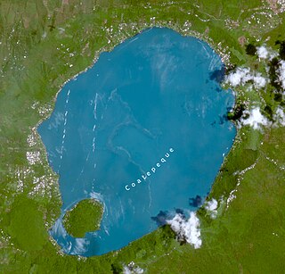
Coatepeque Caldera is a volcanic caldera in El Salvador in Central America. The caldera was formed during a series of rhyolitic explosive eruptions between about 72,000 and 57,000 years ago. Since then, basaltic cinder cones and lava flows formed near the west edge of the caldera, and six rhyodacitic lava domes have formed. The youngest dome, Cerro Pacho, formed after 8000 BC.

Volcán Chingo is a stratovolcano on the border between Guatemala and El Salvador. The largest point on the Guatemala/ El Salvador border is Volcán Chingo at 5,823 feet. It is also known to be the second highest of a group of volcanoes in the SE Guatemala region. The population of people living within 30 km of the Volcán Chingo is estimated to be around 867,678 people. There are no historical eruptions documented for this volcano but it is currently active. The exact volcano number when trying to locate it in the Smithsonian website is 342170.
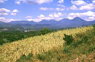
Cordillera de Apaneca is a volcanic mountain range in western El Salvador. It consists mainly of volcanoes. Ilamatepec volcano, one of the most active in the region, is a part of this range.

Izalco is an active stratovolcano on the side of the Santa Ana Volcano, which is located in western El Salvador. It is situated on the southern flank of the Santa Ana volcano. Izalco erupted almost continuously from 1770 to 1958 earning it the nickname of "Lighthouse of the Pacific", and experienced a flank eruption in 1966. During an eruption in 1926, the village of Matazano was buried and 56 people were killed. The volcano erupted on highly arable land which was used for the production of coffee, cacao, and sugar cane.

Chinameca is a stratovolcano in central-eastern El Salvador. It lies north of San Miguel volcano and rises over the town of Chinameca. The volcano is topped by a 2 kilometres (1.2 mi) wide caldera known as Laguna Seca el Pacayal, and a satellite cone on the west side, Cerro el Limbo, rises higher than the caldera rim. Fumaroles can be found on the north side, and it has been the site of a geothermal exploration program.

Conchagua is a stratovolcano in southeastern El Salvador, overlooking the Gulf of Fonseca. Cerro del Ocote and Cerro de la Bandera are the two main summits, with Bandera appearing younger and more conical. There are active fumarolic areas on both peaks, but no confirmed historical eruptions. It is surrounded by forest called Bosque Conchagua. Conchagua, in Native American indigenous Salvadoran Lenca language, means. According to historians, the volcano was settled by the Lenca civilization, who worshipped the goddess Comizahual, an indigenous Jaguar Princess. Lenca legends say that Conchagua was Comizahual's favorite volcano, and upon her death she was taken on top on Conchagua where her body turned into many golden Chiltota birds that took off from Conchagua volcano.
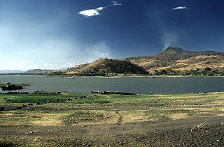
Lake Güija is a lake in Central America. The lake is situated on the border between Guatemala and El Salvador and has an area of 45 km2, of which approximately 32 km2 lies in El Salvador.
Parque Nacional Los Volcanes, also known as Cerro Verde National Park, is a large national park in El Salvador.

Tourism accounts for a large part of El Salvador's economy. El Salvador has many natural attractions including beaches with some of the best surfing breaks on the Pacific Coast. El Salvador offers many lush forests shrouded in cool temperatures with abundant wildlife and scenic mountain-top vistas. El Salvador also has great potential in the field of cultural tourism; with over 2,000 known archaeological sites, mostly of the Maya and Olmec cultures. These sites are of international interest for their easy access and well-preserved remains.
