San Salvador is the capital and the largest city of El Salvador and its eponymous department. It is the country's largest agglomeration, serving as the country's political, cultural, educational and financial center. The municipality of San Salvador has 525,990 inhabitants (2024). The Metropolitan Area of San Salvador, which comprises the capital itself and 13 of its municipalities, has a population of 2,404,097. The urban area of San Salvador has a population of 1,600,000 inhabitants.

Santa Ana is the second largest city in El Salvador, after the capital of San Salvador. It is located 64 kilometers northwest of San Salvador, the capital city. Santa Ana has approximately 277,264 (2020) inhabitants and serves both as the capital of the department of Santa Ana and as the municipal seat for the surrounding municipality of the same name. For its administration the municipality is divided into 35 colonias (neighborhoods) and 318 small villages.

San Salvador is a department of El Salvador in the west central part of the country. The capital is San Salvador, which is also the national capital. The department has North of the Rio Lempa Valley, the "Valle de las Hamacas" and a section of Lake Ilopango. Some of the department's cities that are densely populated are: San Salvador, Ciudad Delgado, Mejicanos, Soyapango, Panchimalco and Apopa. The department covers an area of 886.2 square kilometres (342.2 sq mi) and the last census count in 2017 reported 2,404,097 people. It was classified as a department on June 12, 1824. During the time of the colony, the department was the San Salvador Party, from where territory was taken to make the departments of Chalatenago, La Libertad, Cuscatlán and La Paz. This department produces beans, coffee, sugar cane, etc. for agriculture, on the other hand San Salvador Department holds many headquarters for banking companies in El Salvador and Central America, and for many communication services, also the headquarters of the electric companies are located in the San Salvador Department, last years these companies took a step and started exporting electricity to all Central America. The current mayor of the department is Ernesto Muyshondt (2015–2019)

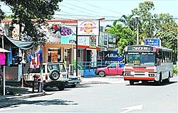
Apopa is a municipality in the San Salvador department of El Salvador. Probably the seventh biggest city in El Salvador with a little more than 150,000 people, the city has now collided with Soyapango and San Salvador, making it part of the San Salvador metropolitan area.

Mejicanos is a district of San Salvador Centro municipality in the San Salvador department of El Salvador.
Tonacatepeque is a district in the San Salvador department of El Salvador. It has a population of 90,896 inhabitants according to the 2007 Census. This makes this municipality twelfth largest in terms of population in El Salvador. It is part of the San Salvador metropolitan area.
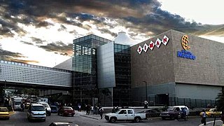
Soyapango is a district in the San Salvador department of El Salvador. Soyapango is the country's largest municipality with 284,700 residents. Soyapango is a satellite city of San Salvador and it is the main thoroughfare between San Salvador and the eastern part of the country, and nearly 70,000 vehicles travel through it every day. The nickname for this satellite city is Soya.
San Juan Tepezontes is a municipality in the La Paz department of El Salvador. Its name is a Hispanicization of a Nawat term meaning "many hills." It was incorporated in 1945. Its population as of 2004 was 3,269.

Antiguo Cuscatlán(colloquially known as Antiguo) is a municipality in the La Libertad department of El Salvador; its eastern tip lies in the San Salvador Department part of the Metropolitan Area of San Salvador, southwest of San Salvador and southeast of Santa Tecla. The population was 47,956 at the 2020 census. Antiguo Cuscatlán can be translated as Old Jeweled City: Antiguo means ancient or old in Spanish, and Cuscatlán means jeweled city in Nahuat. The city used to be the capital of the Pipil or Cuzcatecs, before the Spanish conquest of the New World.
La Libertad ('Liberty') is a municipality in the La Libertad Department of El Salvador. It had a population of 35,997 inhabitants in 2007 according to the official census of that year. It is one of the main tourist attractions in the country.

La Palma is a municipality in the Chalatenango department of El Salvador. The municipality, located in a mountainous area of the country, covers an area of 135.60 km2 and as of 2006 had an approximate population of 24,000.

Juayúa is a city and municipality in the Sonsonate department of El Salvador. It is a small town up in the mountains, founded in 1577. Juayua is located in the western part of El Salvador, about 50 miles from San Salvador.
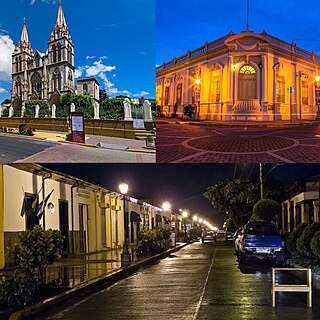
Santa Tecla is a city and a municipality in the La Libertad department of El Salvador. It is the capital of the department of La Libertad.

Chalatenango is a municipality located in the Department of Chalatenango, in the north of El Salvador.

The Metropolitan Area of San Salvador is a metropolitan area formed by San Salvador, the capital of El Salvador, and thirteen of its surrounding municipalities. It was instituted in 1993 through Legislative Decree No. 732 of the Law on Territorial Development and the Metropolitan Area of San Salvador and neighbouring municipalities. The Act defines that, based on their urban development, these cities form a single urban unit.
The municipal districts of San Salvador, the capital city of El Salvador, are naturally delimited by the Acelhuate River on the east, the San Jacinto Hill on the south east, the lower highlands of the Balsam Range on the South, El Picacho Mountain and the Bicentennial Park on the West, and North by the San Antonio River. The municipality is further subdivided into Districts governed by the municipal mayor and by a district board. There are seven districts in San Salvador, districts 1-6 and the Historic Downtown.
Visitors to El Salvador must obtain a visa from one of the Salvadoran diplomatic missions, unless they come from one of the visa exempt countries. All visitors must hold a passport valid for 6 months.

Tourism accounts for a large part of El Salvador's economy. El Salvador has many natural attractions including beaches with some of the best surfing breaks on the Pacific Coast. El Salvador offers many lush forests shrouded in cool temperatures with abundant wildlife and scenic mountain-top vistas. El Salvador also has great potential in the field of cultural tourism; with over 2,000 known archaeological sites, mostly of the Maya and Olmec cultures. These sites are of international interest for their easy access and well-preserved remains.
The final offensive of 1989, also known as the ofensiva hasta el tope, was the major engagement of the Salvadoran Civil War. The battle, fought between the Farabundo Martí National Liberation Front Marxist guerrilla and the Salvadoran government, lasted from 11 November to early December 1989. Sometimes referred to as "Ofensiva fuera los fascistas. Febe Elizabeth vive", in honor of an assassinated union leader, it was the most brutal confrontation in the entire conflict, amounting for seventeen percent of the total casualties in ten years of warfare.