You can help expand this article with text translated from the corresponding article in Spanish. (December 2008)Click [show] for important translation instructions.
|
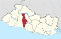
Nejapa | |
|---|---|
District | |
 | |
 Nejapa Location in El Salvador | |
| Coordinates: 13°49′N89°14′W / 13.817°N 89.233°W | |
| Country | |
| Department | San Salvador Department |
| Metro | San Salvador Metropolitan Area |
| Incorporated as Town | 1878 |
| Incorporated as City | 1959 |
| Area | |
• District | 32.2 sq mi (83.4 km2) |
| Elevation | 1,496 ft (456 m) |
| Population (2020) | |
• District | 33,766 |
| • Urban | 18,943 |
| Time zone | UTC−6 (Central Standard Time) |
| SV-SS | CP 1126 |
| Area code | +503 |
| Website | alcaldianejapa.gob.sv/ |
Nejapa is a district in the San Salvador department of El Salvador. It is part of the San Salvador metropolitan area.