San Salvador is the capital and the largest city of El Salvador and its eponymous department. It is the country's largest agglomeration, serving as the country's political, cultural, educational and financial center. The municipality of San Salvador has 525,990 inhabitants (2024). The Metropolitan Area of San Salvador, which comprises the capital itself and 13 of its municipalities, has a population of 2,404,097. The urban area of San Salvador has a population of 1,600,000 inhabitants.

The Pipil are an indigenous group of Mesoamerican people inhabiting the western and central areas of present-day El Salvador. They are a subgroup of the larger Nahua ethnic group. They speak the Nawat language, which is a closely related but distinct language from the Nahuatl of Central Mexico. There are very few speakers of Nawat left, but there are efforts being made to revitalize it.

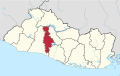
San Salvador is a department of El Salvador in the west central part of the country. The capital is San Salvador, which is also the national capital. The department has North of the Rio Lempa Valley, the "Valle de las Hamacas" and a section of Lake Ilopango. Some of the department's cities that are densely populated are: San Salvador, Ciudad Delgado, Mejicanos, Soyapango, Panchimalco and Apopa. The department covers an area of 886.2 square kilometres (342.2 sq mi) and the last census count in 2017 reported 2,404,097 people. It was classified as a department on June 12, 1824. During the time of the colony, the department was the San Salvador Party, from where territory was taken to make the departments of Chalatenago, La Libertad, Cuscatlán and La Paz. This department produces beans, coffee, sugar cane, etc. for agriculture, on the other hand San Salvador Department holds many headquarters for banking companies in El Salvador and Central America, and for many communication services, also the headquarters of the electric companies are located in the San Salvador Department, last years these companies took a step and started exporting electricity to all Central America. The current mayor of the department is Ernesto Muyshondt (2015–2019)

The culture of El Salvador is a Central American culture nation influenced by the clash of ancient Mesoamerica and medieval Iberian Peninsula. Salvadoran culture is influenced by Native American culture as well as Latin American culture. Mestizo culture, Afro-Latin culture and the Catholic Church dominates the country. Although the Romance language, Castilian Spanish, is the official and dominant language spoken in El Salvador, Salvadoran Spanish which is part of Central American Spanish has influences of Native American languages of El Salvador such as Lencan languages, Cacaopera language, Mayan languages and Pipil language, which are still spoken in some regions of El Salvador.

Lepaera is a municipality in the Honduran department of Lempira. It has tropical climate all year round.
Ilopango is a town and district in the San Salvador department of El Salvador. It is a few miles east of the nation's capital, San Salvador and part of the San Salvador metropolitan area. It is located near Lake Ilopango, the country's largest lake at 72 square kilometers.

San Martín is a district in the San Salvador department of El Salvador. According to the 2007 Population and Housing Census, it has 72,758 inhabitants. The municipality is limited by San José Guayabal and Oratorio de Concepción to the North; San Bartolomé Perulapía and San Pedro Perulapán to the East; by Ilopango and the Lake of Ilopango to the South; and to the West by Tonacatepeque. For its administration it is divided into 8 cantons and 37 hamlets. Its main river is the Chunchucuyo; in terms of its orographyits main elevations are Las Delicias, Chuchutepeque, La Tigra and Teguantepeque hills. Its climate is warm and belongs to the type of hot earth and its annual rainfall amount varies between 1,750 and 1970 mm. The vegetation is constituted by humid subtropical forest. The locality covers an area of 55.8 km2 and the headland has an elevation of 725.0 meters above sea level. The municipality is part of the San Salvador metropolitan area.
Soyapango is a district in the San Salvador department of El Salvador. Soyapango is the country's largest municipality with 284,700 residents. Soyapango is a satellite city of San Salvador and it is the main thoroughfare between San Salvador and the eastern part of the country, and nearly 70,000 vehicles travel through it every day. The nickname for this satellite city is Soya.

Antiguo Cuscatlán(colloquially known as Antiguo) is a municipality in the La Libertad department of El Salvador; its eastern tip lies in the San Salvador Department part of the Metropolitan Area of San Salvador, southwest of San Salvador and southeast of Santa Tecla. The population was 47,956 at the 2020 census. Antiguo Cuscatlán can be translated as Old Jeweled City: Antiguo means ancient or old in Spanish, and Cuscatlán means jeweled city in Nahuat. The city used to be the capital of the Pipil or Cuzcatecs, before the Spanish conquest of the New World.

Nuevo Cuscatlán is a municipality of El Salvador, belonging to the department of La Libertad, it is located 13 kilometers from San Salvador. It borders to the north and east with Antiguo Cuscatlán, to the south with Huizúcar and San José Villanueva and to the west with Santa Tecla.

Nahuizalco is a municipality in the Sonsonate department of El Salvador. It lies on the "flowers route", 9 km from Sonsonate and 74 km from San Salvador, at 540 m above sea level on the southern part of the Apaneca-Ilamatepec mountain range. Per the population and housing census of 2007, Nahuizalco has 49,081 residents.

Suchitoto is a municipality in the Department of Cuscatlán, El Salvador that has seen continuous human habitation long before Spanish colonization. Within its municipal territory, Suchitoto holds the site of the original founding of the Villa of San Salvador in 1528 that existed for a short time before the site was abandoned. In more recent times, the municipality has prospered even after the severe effects of civil war in El Salvador that lasted between 1980 - 1992 and saw the population of Suchitoto decrease from 34,101 people in 1971 to 13,850 by 1992. It has become an important tourist destination partly due to its well conserved colonial architecture and cobblestone roads that provide a sense of Spanish colonial living. This rise in tourism has attracted service sector businesses to open up in the small city including hostels, restaurants, and picturesque cafes. As a result of tourism, many arts and cultural spaces have opened up in Suchitoto that are also providing positive alternative opportunities for youth in the community. According to the 2007 Official Census, the small city has a population of 24,786 people with 7,654 people living in the urban area and 17,132 people living in the rural communities.

Concepción de Ataco is a district and city within the Ahuachapán Department, El Salvador. It has an area of 61.03 km ² and a population of 18,101 inhabitants.

Cuzcatlan was a pre-Columbian Nahua state confederation of the Mesoamerican postclassical period that extended from the Paz river to the Lempa river ; this was the nation that Spanish chroniclers came to call the Pipils or Cuzcatlecos. No codices survive that shed light on this confederation except the Annals of the Cakchiquels, although Spanish chroniclers such as Domingo Juarros, Palaces, Lozano, and others claim that some codices did exist but have since disappeared. Their Nawat language, art and temples revealed that they had significant Mayan and Toltec influence from the ties they had with the Itza in Yucatan. It is believed that the first settlers to arrive came from the Toltec people in central Mexico, mostly Puebla during the Chichimeca-Toltec civil wars in the 10th century AD.

Nicolás Espinoza was a Salvadoran general and licenciado who served as Head of State of El Salvador from April 10, 1835 to November 15, 1835. At the time, El Salvador was a constituent state of the Federal Republic of Central America.
Salvadorans, also known as Salvadorians, are citizens of El Salvador, a country in Central America. Most Salvadorans live in El Salvador, although there is also a significant Salvadoran diaspora, particularly in the United States, with smaller communities in other countries around the world.

Nueva Esparta is a municipality in the northeasternmost zone of El Salvador, inside La Unión Department. The municipality is politically divided into the central Pueblo Nueva Esparta, six outlying canton communities and 31 caserios.

The Metropolitan Area of San Salvador is a metropolitan area formed by San Salvador, the capital of El Salvador, and thirteen of its surrounding municipalities. It was instituted in 1993 through Legislative Decree No. 732 of the Law on Territorial Development and the Metropolitan Area of San Salvador and neighbouring municipalities. The Act defines that, based on their urban development, these cities form a single urban unit.

The Spanish conquest of El Salvador was the campaign undertaken by the Spanish conquistadores against the Late Postclassic Mesoamerican polities in the territory that is now incorporated into the modern Central American country of El Salvador. El Salvador is the smallest country in Central America, and is dominated by two mountain ranges running east–west. Its climate is tropical, and the year is divided into wet and dry seasons. Before the conquest the country formed a part of the Mesoamerican cultural region, and was inhabited by a number of indigenous peoples, including the Pipil, the Lenca, the Xinca, and Maya. Native weaponry consisted of spears, bows and arrows, and wooden swords with inset stone blades; they wore padded cotton armour.
The 2022–23 season will be El Salvador's Segunda División de Fútbol Salvadoreño. The season will be split into two championships Apertura 2022 and Clausura 2023. The champions of the Apertura and Clausura play the direct promotion playoff every year. The winner of that series ascends to Primera División de Fútbol de El Salvador.