Santiago Texacuangos

Last updated

Santiago Texacuangos
Municipality
Stgo Texacuangos Alcaldia.jpg
Santiago Texacuangos City Hall
El Salvador location map.svg
Red pog.svg
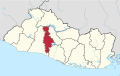
Santiago Texacuangos
Location in El Salvador
Coordinates: 13°39′N89°07′W / 13.650°N 89.117°W / 13.650; -89.117
CountryFlag of El Salvador.svg  El Salvador
Department San Salvador Department
Area
  Total11.8 sq mi (30.5 km2)
Elevation
2,680 ft (817 m)
Population
 (2007)
  Total19,428

Santiago Texacuangos is a municipality in the San Salvador department of El Salvador. It is near Lake Ilopango. [1]

Related Research Articles

<span class="mw-page-title-main">San Salvador</span> Capital of El Salvador

San Salvador is the capital and the largest city of El Salvador and its eponymous department. It is the country's political, cultural, educational and financial center. The Municipality of San Salvador has 209,633 inhabitants (2020). The Metropolitan Area of San Salvador, which comprises the capital itself and 13 of its municipalities, has a population of 2,404,097. The urban area of San Salvador has a population of 1,600,000 inhabitants.

<span class="mw-page-title-main">San Salvador Department</span> Department of El Salvador

San Salvador is a department of El Salvador in the west central part of the country. The capital is San Salvador, which is also the national capital. The department has North of the Rio Lempa Valley, the "Valle de las Hamacas" and a section of Lake Ilopango. Some of the department's cities that are densely populated are: San Salvador, Ciudad Delgado, Mejicanos, Soyapango, Panchimalco and Apopa. The department covers an area of 886.2 square kilometres (342.2 sq mi) and the last census count in 2017 reported 2,404,097 people. It was classified as a department on June 12, 1824. During the time of the colony, the department was the San Salvador Party, from where territory was taken to make the departments of Chalatenago, La Libertad, Cuscatlán and La Paz. This department produces beans, coffee, sugar cane, etc. for agriculture, on the other hand San Salvador Department holds many headquarters for banking companies in El Salvador and Central America, and for many communication services, also the headquarters of the electric companies are located in the San Salvador Department, last years these companies took a step and started exporting electricity to all Central America. The current mayor of the department is Ernesto Muyshondt (2015–2019)

<span class="mw-page-title-main">Legislative Assembly of El Salvador</span> Government body of El Salvador

The Legislative Assembly is the legislative branch of the government of El Salvador.

<span class="mw-page-title-main">Ilopango</span> Municipality in San Salvador Department, El Salvador

Ilopango is a town in the San Salvador department of El Salvador. It is a few miles east of the nation's capital, San Salvador. It is located near Lake Ilopango, the country's largest lake at 72 square kilometers.

<span class="mw-page-title-main">San Martín, El Salvador</span> Municipality in San Salvador Department, El Salvador

San Martín is a municipality in the San Salvador department of El Salvador. According to the 2007 Population and Housing Census, it has 72,758 inhabitants. The municipality is limited by San José Guayabal and Oratorio de Concepción to the North; San Bartolomé Perulapía and San Pedro Perulapán to the East; by Ilopango and the Lake of Ilopango to the South; and to the West by Tonacatepeque. For its administration it is divided into 8 cantons and 37 hamlets. Its main river is the Chunchucuyo; in terms of its orographyits main elevations are Las Delicias, Chuchutepeque, La Tigra and Teguantepeque hills. Its climate is warm and belongs to the type of hot earth and its annual rainfall amount varies between 1,750 and 1970 mm. The vegetation is constituted by humid subtropical forest. The locality covers an area of 55.8 km2 and the headland has an elevation of 725.0 meters above sea level. The municipality belongs to the Metropolitan Area of San Salvador.

Tonacatepeque is a municipality in the San Salvador department of El Salvador. It has a population of 90,896 inhabitants according to the 2007 Census. This makes this municipality twelfth largest in terms of population in El Salvador.

<span class="mw-page-title-main">Soyapango</span> City and Municipality in San Salvador Department, El Salvador

Soyapango is a municipality in the San Salvador department of El Salvador. Soyapango is a commercial center. The municipality is the third most populated area in the country, with 290,412 inhabitants. Soyapango is a satellite city of San Salvador and it is the main thoroughfare between San Salvador and the eastern part of the country, and nearly 70,000 vehicles travel through it every day. The nickname for this satellite city is Soya.

Verapaz is a municipality in the San Vincente department of El Salvador. Verapaz means 'true peace'. It has been the site of two recent natural disasters; an earthquake measuring 6.6 on the Moment magnitude scale on 13 February 2001 and the 2009 Salvador floods and mudslides in November 2009.

<span class="mw-page-title-main">Chalchuapa</span> Place in Santa Ana Department, El Salvador

Chalchuapa is a town and a municipality located in the Santa Ana department of El Salvador. The city of Chalchuapa is in a wide valley at 650 meters above sea level, and watered by the Pampe River.

<span class="mw-page-title-main">Acajutla</span> City in Sonsonate Department, El Salvador

Acajutla is a seaport city in Sonsonate Department, El Salvador. The city is located at 13°35′24″N89°50′01″W on the Pacific coast of Central America and is El Salvador's principal seaport from which a large portion of the nation's exports of coffee, sugar, and Balsam of Peru are shipped. As a city, Acajutla is one of seventeen such districts in Sonsonate. As of 1992, the population of the city was 18,008.

<span class="mw-page-title-main">San Andrés, El Salvador</span>

San Andrés is a pre-Columbian site in El Salvador, whose occupation began around the year 900 BC as an agricultural town in the valley of Zapotitán in the department of La Libertad. This early establishment was vacated by the year 250 because of the enormous eruption of the caldera of Lago Ilopango, and was occupied again in the 5th Century, along with many other sites in the valley of Zapotitán. Between 600 and 900 AD, San Andrés was the capital of a Maya polity with supremacy over the other establishments of Valle de Zapotitán.

<span class="mw-page-title-main">Lake Ilopango</span> Crater lake in El Salvador which fills a caldera

Lake Ilopango is a crater lake which fills an 8 by 11 km volcanic caldera in central El Salvador, on the borders of the San Salvador, La Paz, and Cuscatlán departments. The caldera, which contains the second largest lake in the country and is immediately east of the capital city, San Salvador, has a scalloped 100 m (330 ft) to 500 m (1,600 ft) high rim. Any surplus drains via the Jiboa River to the Pacific Ocean. The local military airbase, Ilopango International Airport, has annual airshows where international pilots from all over the world fly over San Salvador City and Ilopango lake.

<span class="mw-page-title-main">Ilopango International Airport</span> Regional airport located in Ilopango, San Salvador, El Salvador

Ilopango International Airport is an airport located on the eastern part of the city of San Salvador, El Salvador, once serving the city as its international airport until 1980 when it was replaced by the larger and more modern El Salvador International Airport, located about 50 km south of the city. Currently, Ilopango is used for military, air taxi, and charter aviation only. It also holds the annual Ilopango Air Show. The airport is also home to the National Aviation Museum of San Salvador, which is housed in the old terminal building.

The Civil Aviation Authority is the civil aviation agency of El Salvador. The agency conducts investigations into aviation accidents and incidents. The agency is headquartered in Ilopango Airport in Ilopango, San Salvador Department. Honduran authorities delegated the investigation of the TACA Flight 390 incident to the Salvadoran Civil Aviation Authority as per the Convention on International Civil Aviation.

San Salvador el Seco (municipality) is a town and municipality in the Mexican state of Puebla in south-eastern Mexico.

<span class="mw-page-title-main">Late Antique Little Ice Age</span> Northern Hemispheric cooling period

The Late Antique Little Ice Age (LALIA) was a long-lasting Northern Hemispheric cooling period in the 6th and 7th centuries AD, during the period known as Late Antiquity. The period coincides with three large volcanic eruptions in 535/536, 539/540 and 547. The volcanic winter of 536 was the early phenomenon of the century-long global temperature decline. One study suggested a global cooling of 2 °C (3.6 °F).

The Battle of Ilopango Airport was a military engagement fought at the Ilopango International Airport in El Salvador in late January 1981. The battle was a part of the Salvadoran Civil War. It was fought between soldiers of the Salvadoran Air Force and guerrillas of the Farabundo Martí National Liberation Front.

<span class="mw-page-title-main">Tierra Blanca Joven eruption</span> Catastrophic volcanic eruption of Lake Ilopango in El Salvador

The Tierra Blanca Joven eruption of Lake Ilopango was the largest volcanic eruption in El Salvador during historic times, and one of the largest volcanic events on Earth in the past 7,000 years, registering at 6 on the Volcanic explosivity index (VEI), and dating back to the mid 5th century A.D. The eruption produced between 37–82 km3 (8.9–19.7 cu mi) of ejecta. The date of the eruption has been constrained within 429–433 CE by identifying its signature volcanic ash in precision-dated ice cores sampled from Greenland, thus eliminating it as the cause of extreme weather events of 535–536.

The 1965 San Salvador earthquake occurred at 04:01 in the morning on May 3, 1965. It had a moment magnitude of 5.9 and a maximum Mercalli intensity of VIII (Severe). The shock caused severe damage to El Salvador's capital city, San Salvador. The town of Ilopango, Soyapango, and Delgado was also hard hit. The earthquake was the most destructive to affect the city prior to the 1986 earthquake.

References

  1. González Choto, Daniel (6 May 2008). "Proyecto de Ilopango costaría $300 millones". Siglo Veintiuno. Retrieved 31 May 2024 via ProQuest.

13°39′N89°07′W / 13.650°N 89.117°W / 13.650; -89.117

Santiago Texacuangos seen at night Stgo Texacuangos El Salvador 2012.jpg
Santiago Texacuangos seen at night