Geography of El Salvador

Last updated

El Salvador is a country in Central America. Situated at the meeting point of three tectonic plates, it is highly seismologically active and the location of numerous earthquakes and volcanic eruptions. The country has a tropical climate.

Contents

Geography of El Salvador
Un-el-salvador.png
Continent North America
Region Central America
Area Ranked 148th
  Total21,041 km2 (8,124 sq mi)
  Land98.48%
  Water1.52%
Coastline307 km (191 mi)
BordersTotal border: 590 km (370 mi)
Highest point Cerro El Pital
2,730 metres (8,960 ft)
Lowest point Pacific Ocean
0 metres (0 ft)
Longest river Rio Lempa
422 km (262 mi)
Largest lake Lago de Ilopango
72 km2 (28 sq mi)
Exclusive economic zone90,962 km2 (35,121 sq mi)

Plate tectonics

El Salvador relief map Relief Model of El Salvador (7185452566).jpg
El Salvador relief map
Middle America Trench subduction zone Subduction-en.svg
Middle America Trench subduction zone

El Salvador, along with the rest of Central America, is one of the most seismologically active regions on earth, situated atop three of the large tectonic plates that constitute the Earth's surface. [1] The motion of these plates causes the area's earthquake and volcanic activity. [1]

Most of Central America and the Caribbean Basin rests on the relatively motionless Caribbean Plate. The Pacific Ocean floor, however, is being carried northeast by the underlying motion of the Cocos Plate. [1] Ocean floor material is largely composed of basalt, which is relatively dense; when it collides with the lighter granite rocks of Central America, the ocean floor is forced down under the land mass, creating the deep Middle America Trench that lies off the coast of El Salvador. [1]

The subduction of the Cocos Plate accounts for the frequency of earthquakes near the coast. [1] As the rocks constituting the ocean floor are forced down, they melt, and the molten material pours up through weaknesses in the surface rock, producing volcanoes and geysers. [1]

North of El Salvador, Mexico and most of Guatemala are riding on the westward-moving North American Plate that butts against the northern edge of the stationary Caribbean Plate in southern Guatemala. [1] The grinding action of these two plates creates a fault (similar to the San Andreas fault in California) that runs the length of the valley of the Rio Motagua in Guatemala. [1] Motion along this fault is the source of earthquakes in northernmost El Salvador. [1]

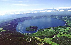
El Salvador has a long history of destructive earthquakes and volcanic eruptions. [1] San Salvador was destroyed in 1756 and 1854, and suffered heavy damage in the 1919, 1982, and 1986 tremors. [1] The country has over twenty volcanoes, although only two, San Miguel and Izalco, have been active in recent years. [1] From the early nineteenth century to the mid-1950s, Izalco erupted with a regularity that earned it the name "Lighthouse of the Pacific". [1] Its brilliant flares were clearly visible for great distances at sea, and at night its glowing lava turned it into a brilliant luminous cone. [1]

Physical features

El Salvador's topography. El Salvador Topography.png
El Salvador's topography.
Economic activity of El Salvador, 1980. El salvador econ 1980.jpg
Economic activity of El Salvador, 1980.
Vegetation and land use, 1980. El salvador land 1980.jpg
Vegetation and land use, 1980.

Two parallel mountain ranges cross El Salvador to the west with a central plateau between them and a narrow coastal plain hugging the Pacific. [1] These physical features divide the country into two physiographic regions. [1] The mountain ranges and central plateau, covering 85 percent of the land, comprise the interior highlands. [1] The remaining coastal plains are referred to as the Pacific lowlands. [1]

The northern range of mountains, the Sierra Madre, form a continuous chain along the border with Honduras. Elevations in this region range from 1,600 to 2,700 meters. [1] The area was once heavily forested, but overexploitation led to extensive erosion, and it has become semibarren. [1] As a result, it is the country's most sparsely populated zone, with little farming or other development. [1]

The southern range of mountains is actually a discontinuous chain of more than twenty volcanoes, clustered into five groups. [1] The westernmost group, near the Guatemalan border, contains Izalco and Santa Ana, which at 2,365 meters is the highest volcano in El Salvador. [1] Between the cones lie alluvial basins and rolling hills eroded from ash deposits. [1] The volcanic soil is rich, and much of El Salvador's coffee is planted on these slopes. [1]

The central plateau constitutes only 25 percent of the land area but contains the heaviest concentration of population and the country's largest cities. [1] This plain is about 50 kilometers wide and has an average elevation of 600 meters. Terrain here is rolling, with occasional escarpments, lava fields, and geysers. [1]

A narrow plain extends from the coastal volcanic range to the Pacific Ocean. [1] This region has a width ranging from one to thirty-two kilometers with the widest section in the east, adjacent to the Golfo de Fonseca. [1] Near La Libertad, however, the mass of the mountains push the lowlands out; the slopes of adjacent volcanoes come down directly to the ocean. [1] Surfaces in the Pacific lowlands are generally flat or gently rolling and result from the alluvial deposits of nearby slopes. [1]

El Salvador has over 300 rivers, the most important of which is the Rio Lempa. [1] Originating in Guatemala, the Rio Lempa cuts across the northern range of mountains, flows along much of the central plateau, and finally cuts through the southern volcanic range to empty into the Pacific. [1] It is El Salvador's only navigable river, it and its tributaries drain about half the country. [1] Other rivers are generally short and drain the Pacific lowlands or flow from the central plateau through gaps in the southern mountain range to the Pacific. [1]

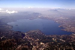
Numerous lakes of volcanic origin are found in the interior highlands; many of these lakes are surrounded by mountains and have high, steep banks. [1] The largest lake, the Lago de Ilopango, lies just to the east of the capital. [1] Other large lakes include the Lago de Coatepeque in the west and the Lago de Güija on the Guatemalan border. [1] The Cerron Grande Dam on the Rio Lempa has created a large reservoir, the Embalse Cerron Grande, in northern El Salvador. [1]

Izalco has erupted at least 54 times since 1770. [2] It earned the nickname "Lighthouse of the Pacific" because it served as a beacon for ships during the night. [2]

Climate

Koppen climate classification of El Salvador. Koppen-Geiger Map SLV present.svg
Köppen climate classification of El Salvador.

El Salvador has a tropical climate with pronounced wet and dry seasons. [1] Temperatures vary primarily with elevation and show little seasonal change. [1] The Pacific lowlands are uniformly hot and humid; the central plateau and mountain areas are more moderate. [1]

The rainy season, known locally as invierno, or winter, extends from May to October. [1] Almost all the annual rainfall during this time, and yearly rain totals, particularly on southern-facing mountain slopes, can be as high as 2,000 millimeters (78.7 in). [1] Protected areas and the central plateau receive lesser, although still significant, amounts. [1] Rainfall during this season generally comes from low pressure over the Pacific and usually falls in heavy afternoon thunderstorms. [1] Although hurricanes occasionally form in the Pacific, they seldom affect El Salvador, with the notable exception of Hurricane Mitch in 1998 (which actually formed over the Atlantic Basin) and Hurricane Emily in 1973. [1]

From November through April, the northeast trade winds control weather patterns. [1] During these months, air flowing from the Caribbean has lost most of its precipitation while passing over the mountains in Honduras. [1] By the time this air reaches El Salvador, it is dry, hot, and hazy. [1] This season is known locally as verano, or summer. [1]

Temperatures vary little with season; elevation is the primary determinant. [1] The Pacific lowlands are the hottest region, with annual averages ranging from 25 to 29 °C (77.0 to 84.2 °F). [1] San Salvador is representative of the central plateau, with an annual average temperature of 23 °C (73 °F) and absolute high and low readings of 38 and 6 °C (100.4 and 42.8 °F), respectively. [1] Mountain areas are the coolest, with annual averages from 12 to 23 °C (53.6 to 73.4 °F) and minimum temperatures sometimes approaching freezing. [1]

Climate data for San Salvador (Ilopango International Airport) 1981-2010, extremes 1957-present
MonthJanFebMarAprMayJunJulAugSepOctNovDecYear
Record high °C (°F)36.0
(96.8)
36.1
(97.0)
37.2
(99.0)
38.4
(101.1)
36.7
(98.1)
34.6
(94.3)
34.5
(94.1)
35.1
(95.2)
33.3
(91.9)
35.6
(96.1)
35.3
(95.5)
35.7
(96.3)
38.4
(101.1)
Average high °C (°F)30.8
(87.4)
32.0
(89.6)
32.7
(90.9)
32.7
(90.9)
31.1
(88.0)
30.1
(86.2)
30.3
(86.5)
30.5
(86.9)
29.5
(85.1)
29.5
(85.1)
29.9
(85.8)
30.2
(86.4)
30.8
(87.4)
Daily mean °C (°F)22.8
(73.0)
23.6
(74.5)
24.2
(75.6)
25.0
(77.0)
24.6
(76.3)
23.9
(75.0)
23.9
(75.0)
23.9
(75.0)
23.3
(73.9)
23.3
(73.9)
23.0
(73.4)
22.8
(73.0)
23.7
(74.7)
Average low °C (°F)16.9
(62.4)
17.6
(63.7)
18.4
(65.1)
19.8
(67.6)
20.4
(68.7)
20.0
(68.0)
19.5
(67.1)
19.7
(67.5)
19.6
(67.3)
19.3
(66.7)
18.4
(65.1)
17.5
(63.5)
18.9
(66.0)
Record low °C (°F)11.9
(53.4)
12.0
(53.6)
13.0
(55.4)
12.0
(53.6)
12.0
(53.6)
15.5
(59.9)
13.5
(56.3)
12.2
(54.0)
15.0
(59.0)
12.5
(54.5)
11.1
(52.0)
12.0
(53.6)
11.1
(52.0)
Average rainfall mm (inches)1
(0.0)
2
(0.1)
10
(0.4)
36
(1.4)
176
(6.9)
279
(11.0)
355
(14.0)
319
(12.6)
338
(13.3)
208
(8.2)
53
(2.1)
9
(0.4)
1,786
(70.4)
Average rainy days (≥ 0.1 mm)111513202020201642123
Average relative humidity (%)67666772808382838683767277
Mean monthly sunshine hours 3012772942432201742392571802112672942,957
Source 1: Ministerio de Medio Ambiente y Recursos Naturales [3]
Source 2: Danish Meteorological Institute (precipitation days and sun 1931–1960), [4] Meteo Climat (record highs and lows) [5]
Climate data for Santa Ana, El Salvador (1981–2010)
MonthJanFebMarAprMayJunJulAugSepOctNovDecYear
Record high °C (°F)33.5
(92.3)
35.7
(96.3)
37.0
(98.6)
36.0
(96.8)
35.4
(95.7)
33.8
(92.8)
32.7
(90.9)
33.6
(92.5)
32.3
(90.1)
32.5
(90.5)
32.5
(90.5)
33.5
(92.3)
37.0
(98.6)
Average high °C (°F)30.8
(87.4)
32.1
(89.8)
33.7
(92.7)
34.1
(93.4)
32.3
(90.1)
30.9
(87.6)
31.1
(88.0)
31.1
(88.0)
30.3
(86.5)
30.1
(86.2)
30.0
(86.0)
30.3
(86.5)
31.4
(88.5)
Daily mean °C (°F)23.7
(74.7)
24.6
(76.3)
25.7
(78.3)
26.6
(79.9)
26.2
(79.2)
25.3
(77.5)
25.3
(77.5)
25.3
(77.5)
24.7
(76.5)
24.5
(76.1)
24.0
(75.2)
23.8
(74.8)
25.0
(77.0)
Average low °C (°F)16.3
(61.3)
17.0
(62.6)
17.7
(63.9)
18.9
(66.0)
19.6
(67.3)
19.5
(67.1)
19.2
(66.6)
19.3
(66.7)
19.1
(66.4)
19.0
(66.2)
17.8
(64.0)
16.9
(62.4)
18.4
(65.1)
Record low °C (°F)11.0
(51.8)
8.0
(46.4)
11.6
(52.9)
13.0
(55.4)
14.5
(58.1)
13.0
(55.4)
15.0
(59.0)
15.5
(59.9)
15.4
(59.7)
15.0
(59.0)
12.5
(54.5)
10.0
(50.0)
8.0
(46.4)
Average precipitation mm (inches)2
(0.1)
6
(0.2)
8
(0.3)
57
(2.2)
188
(7.4)
322
(12.7)
297
(11.7)
313
(12.3)
315
(12.4)
185
(7.3)
38
(1.5)
13
(0.5)
1,745
(68.7)
Average relative humidity (%)66636364738077788278726872
Mean monthly sunshine hours 310.0271.2291.4258.0254.2198.0263.5260.4204.0229.4267.0303.83,110.9
Mean daily sunshine hours 10.09.69.48.68.26.68.58.46.87.48.99.88.5
Source 1: Ministerio de Medio Ambiente y Recursos Naturales [6]
Source 2: Deutscher Wetterdienst (precipitation days and sun) [7]
Climate data for San Miguel, El Salvador (1981–2010)
MonthJanFebMarAprMayJunJulAugSepOctNovDecYear
Average high °C (°F)36.9
(98.4)
38.0
(100.4)
38.4
(101.1)
38.6
(101.5)
36.2
(97.2)
34.4
(93.9)
34.9
(94.8)
34.9
(94.8)
33.9
(93.0)
33.2
(91.8)
34.2
(93.6)
35.6
(96.1)
35.7
(96.3)
Daily mean °C (°F)27.6
(81.7)
28.4
(83.1)
29.5
(85.1)
30.6
(87.1)
29.8
(85.6)
28.6
(83.5)
28.5
(83.3)
28.5
(83.3)
27.9
(82.2)
27.6
(81.7)
27.4
(81.3)
27.3
(81.1)
28.5
(83.3)
Average low °C (°F)18.3
(64.9)
18.9
(66.0)
20.5
(68.9)
22.7
(72.9)
23.3
(73.9)
22.8
(73.0)
22.2
(72.0)
22.2
(72.0)
22.3
(72.1)
22.0
(71.6)
20.6
(69.1)
19.0
(66.2)
21.2
(70.2)
Average precipitation mm (inches)1
(0.0)
1
(0.0)
6
(0.2)
24
(0.9)
207
(8.1)
239
(9.4)
212
(8.3)
255
(10.0)
321
(12.6)
210
(8.3)
59
(2.3)
7
(0.3)
1,544
(60.8)
Average relative humidity (%)59575762717775768181736470
Source: Ministerio de Medio Ambiente y Recursos Naturales [8]

Other facts

The total land area of El Salvador is 23,041 km2, with 20,721 km2 of land and 320 km2 of water. El Salvador is about the size of Israel and the U.S states of New Jersey and Vermont, but has the population size of Libya and Lebanon. El Salvador has 590 km of borders, including 391 km of borders with Honduras and 199 km with Guatemala. El Salvador has a coastline of 307 km.

El Salvador claims a territorial sea of 200 nautical miles (370.4 km; 230.2 mi).

The lowest point of elevation in El Salvador is the Pacific Ocean, at sea level. The highest point is Cerro El Pital, at 2,730 m.

Maritime claims:
Exclusive economic zone:90,962 km2 (35,121 sq mi)

Natural resources: Hydropower, geothermal power, petroleum, arable land

Land use (2012 estimate) includes 34.03 percent arable land, 10.86 percent permanent crops, 55.12 percent other.

Irrigated land: 449.9 km2 (2003)

Total renewable water resources: 25.23 km3 (2011)

Natural hazards: El Salvador is known as the "Land of Volcanoes"; there are frequent and sometimes very destructive earthquakes and volcanic activity; [9] hurricanes rarely make direct landfall. [10]

Extreme points

Environmental issues

Deforestation; soil erosion; water pollution; contamination of soils from disposal of toxic wastes.

El Salvador is party to the Convention on Biological Diversity, United Nations Framework Convention on Climate Change, Kyoto Protocol to the United Nations Framework Convention on Climate Change, United Nations Convention to Combat Desertification, CITES, Basel Convention, Partial Test Ban Treaty, Montreal Protocol, Ramsar Convention. El Salvador has signed, but not ratified the United Nations Convention on the Law of the Sea.

Related Research Articles

<span class="mw-page-title-main">El Salvador</span> Country in Central America

El Salvador, officially the Republic of El Salvador, is a country in Central America. It is bordered on the northeast by Honduras, on the northwest by Guatemala, and on the south by the Pacific Ocean. El Salvador's capital and largest city is San Salvador. The country's population in 2022 is estimated to be 6.5 million.

<span class="mw-page-title-main">Geography of Honduras</span> Geography of the Central American country

Honduras is a country in Central America. Honduras borders the Caribbean Sea and the North Pacific Ocean. Guatemala lies to the west, Nicaragua south east and El Salvador to the south west. Honduras is the second largest Central American republic, with a total area of 112,890 square kilometres (43,590 sq mi).

<span class="mw-page-title-main">Geography of Mexico</span> Overview of the geography of Mexico

The geography of Mexico describes the geographic features of Mexico, a country in the Americas. Mexico is located at about 23° N and 102° W in the southern portion of North America. From its farthest land points, Mexico is a little over 3,200 km (2,000 mi) in length. Mexico is bounded to the north by the United States, to the west and south by the Pacific Ocean, to the east by the Gulf of Mexico, and to the southeast by Belize, Guatemala, and the Caribbean Sea. The northernmost constituent of Latin America, it is the most populous Spanish-speaking country in the world. Mexico is the world's 13th largest country, three times the size of Texas.

<span class="mw-page-title-main">Geography of Guatemala</span>

Guatemala is mountainous, except for the south coastal area and the vast northern lowlands of Petén department. The country is located in Central America and bounded to the north and west by Mexico, to the northeast by Belize and by the Gulf of Honduras, to the east by Honduras, to the southeast by El Salvador, and to the south by the Pacific Ocean. Two mountain chains enter Guatemala from west to east, dividing the country into three major regions: the highlands, where the mountains are located; the Pacific coast, south of the mountains; and the limestone plateau of the Petén region, north of the mountains. These areas vary in climate, elevation, and landscape, providing dramatic contrasts between hot and humid tropical lowlands and highland peaks and valleys.

<span class="mw-page-title-main">Ring of Fire</span> Region around the rim of the Pacific Ocean where many volcanic eruptions and earthquakes occur

The Ring of Fire is a region around much of the rim of the Pacific Ocean where many volcanic eruptions and earthquakes occur. The Ring of Fire is a horseshoe-shaped belt about 40,000 km (25,000 mi) long and up to about 500 km (310 mi) wide.

<span class="mw-page-title-main">Santa Ana, El Salvador</span> Place in El Salvador

Santa Ana is the second largest city in El Salvador, after the capital of San Salvador. It is located 64 kilometers northwest of San Salvador, the capital city. Santa Ana has approximately 374,830 (2017)) inhabitants and serves both as the capital of the department of Santa Ana and as the municipal seat for the surrounding municipality of the same name. For its administration the municipality is divided into 35 colonias (neighborhoods) and 318 small villages.

<span class="mw-page-title-main">Caribbean Plate</span> A mostly oceanic tectonic plate including part of Central America and the Caribbean Sea

The Caribbean Plate is a mostly oceanic tectonic plate underlying Central America and the Caribbean Sea off the north coast of South America.

<span class="mw-page-title-main">Nahuizalco</span>

Nahuizalco is a municipality in the Sonsonate department of El Salvador. It lies on the "flowers route", 9 km from Sonsonate and 74 km from San Salvador, at 540 m above sea level on the southern part of the Apaneca-Ilamatepec mountain range. Per the population and housing census of 2007, Nahuizalco has 49,081 residents.

<span class="mw-page-title-main">Sierra Madre de Chiapas</span> Mountain range in Central America

The Sierra Madre is a major mountain range in Central America. It is known as the Sierra Madre de Chiapas in Mexico, It crosses El Salvador, Guatemala, Mexico and Honduras. The Sierra Madre is part of the American Cordillera, a chain of mountain ranges that consists of an almost continuous sequence of mountain ranges that form the western "backbone" of North America, Central America, and South America.

<span class="mw-page-title-main">Izalco (volcano)</span> Active stratovolcano in El Salvador

Izalco is an active stratovolcano on the side of the Santa Ana Volcano, which is located in western El Salvador. It is situated on the southern flank of the Santa Ana volcano. Izalco erupted almost continuously from 1770 to 1958 earning it the nickname of "Lighthouse of the Pacific", and experienced a flank eruption in 1966. During an eruption in 1926, the village of Matazano was buried and 56 people were killed. The volcano erupted on highly arable land which was used for the production of coffee, cacao, and sugar cane.

<span class="mw-page-title-main">Geology of the Pacific Northwest</span> Geology of Oregon and Washington (United States) and British Columbia (Canada)

The geology of the Pacific Northwest includes the composition, structure, physical properties and the processes that shape the Pacific Northwest region of North America. The region is part of the Ring of Fire: the subduction of the Pacific and Farallon Plates under the North American Plate is responsible for many of the area's scenic features as well as some of its hazards, such as volcanoes, earthquakes, and landslides.

<span class="mw-page-title-main">Geology of Chile</span>

The geology of Chile is a characterized by processes linked to subduction such as volcanism, earthquakes and orogeny. The buildings blocks of Chile's geology assembled during the Paleozoic Era. Chile was by then the southwestern margin of the supercontinent Gondwana. In the Jurassic Gondwana began to split and the ongoing period of crustal deformation and mountain building known as the Andean orogeny began. In the Late Cenozoic Chile definitely separated from Antarctica, the Andes experienced a great rise accomplained by a cooling climate and the onset of glaciations.

<span class="mw-page-title-main">Outline of El Salvador</span> Overview of and topical guide to El Salvador

El Salvador – sovereign country located on the Pacific Coast of Central America. The area was originally called by the Pipil "Cuzhcatl", in Spanish "Cuzcatlan", which in Nahuatl means "The Land Of Precious Things". After the Spanish conquest, the land was baptized by Spanish conquistadors as "Provincia De Nuestro Señor Jesucristo El Salvador Del Mundo", now abbreviated as "República de El Salvador". The country borders the Pacific Ocean between Guatemala and Honduras. With a population of approximately 5.8 million people, it is the most densely populated nation in Central America and is undergoing rapid industrialization.

<span class="mw-page-title-main">2009 El Salvador floods and mudslides</span>

The 2009 El Salvador floods and mudslides occurred November 6–9 affecting areas including San Salvador, La Paz, Cuscatlan, Usulutan and San Vicente. The disaster was triggered by a low-pressure system from the Pacific, and flooding from heavy rains caused mud and rock slides that killed approximately 130 people and left 60 missing.

<span class="mw-page-title-main">Postage stamps and postal history of El Salvador</span>

El Salvador became independent from Spain in 1821. It has produced its own stamps since 1867.

Water resources management in El Salvador is characterized by difficulties in addressing severe water pollution throughout much of the country's surface waters due to untreated discharges of agricultural, domestic and industrial run off. The river that drains the capital city of San Salvador is considered to be polluted beyond the capability of most treatment procedures.

<span class="mw-page-title-main">Tourism in El Salvador</span>

Tourism accounts for a large part of El Salvador's economy. El Salvador has many natural attractions including beaches with some of the best surfing breaks on the Pacific Coast. El Salvador offers many lush forests shrouded in cool temperatures with abundant wildlife and scenic mountain-top vistas. El Salvador also has great potential in the field of cultural tourism; with over 2,000 known archaeological sites, mostly of the Maya and Olmec cultures. These sites are of international interest for their easy access and well preserved remains.

The Chortis Highlands is a highland region in northern Central America, which covers portions of Guatemala, El Salvador, Honduras, and Nicaragua.

<i>Timeless Stories of El Salvador</i> Series of fairytales and legends by Salvadoran author Federico Navarrete

Timeless Stories of El Salvador is a series of fairytales and legends by Salvadoran author Federico Navarrete. The first volume was published in 2020 in Łódź, Poland, and the second was published in 2022 in Madrid, Spain. Both were published independently in collaboration with the Embassy of El Salvador in Germany.

References

  1. 1 2 3 4 5 6 7 8 9 10 11 12 13 14 15 16 17 18 19 20 21 22 23 24 25 26 27 28 29 30 31 32 33 34 35 36 37 38 39 40 41 42 43 44 45 46 47 48 49 50 51 52 53 54 55 PD-icon.svg This article incorporates text from this source, which is in the public domain :Helms, Mary W. (1990). "Geography". In Haggerty, Richard A. (ed.). El Salvador: a country study. Washington, D.C.: Federal Research Division, Library of Congress. pp. 49–53. OCLC   44362656.
  2. 1 2 Venzke, E, ed. (2013). "Volcanoes of the World, v. 4.3.4". doi:10.5479/si.gvp.votw4-2013.{{cite journal}}: Cite journal requires |journal= (help)
  3. "Normales Climatológicas 1981-2010" (in Spanish). Ministerio de Medio Ambiente y Recursos Naturales. Archived from the original on 14 September 2019. Retrieved 14 September 2019.
  4. Cappelen, John; Jensen, Jens. "El Salvador – San Salvador (pg 85)" (PDF). Climate Data for Selected Stations (1931–1960) (in Danish). Danish Meteorological Institute. Archived from the original (PDF) on 27 April 2013. Retrieved 18 December 2012.
  5. "Station San Salvador" (in French). Meteo Climat. Retrieved 2 May 2017.
  6. "Normales Climatológicas 1981-2010" (in Spanish). Ministerio de Medio Ambiente y Recursos Naturales. Archived from the original on September 14, 2019. Retrieved September 15, 2019.
  7. "Klimatafel von Santa Ana / El Salvador" (PDF). Baseline climate means (1961-1990) from stations all over the world (in German). Deutscher Wetterdienst. Retrieved May 2, 2017.
  8. "Normales Climatológicas 1981-2010" (in Spanish). Ministerio de Medio Ambiente y Recursos Naturales. Archived from the original on September 14, 2019. Retrieved September 15, 2019.
  9. "Fast Facts: Republic of El Salvador". Nat Geo Kids. National Geographic Partners, LLC. Retrieved 22 January 2021.
  10. "Current Hurricanes in El Salvador". Worlddata.info. Retrieved 9 August 2022.