An interplate earthquake is an earthquake that occurs at the boundary between two tectonic plates. Earthquakes of this type account for more than 90 percent of the total seismic energy released around the world. If one plate is trying to move past the other, they will be locked until sufficient stress builds up to cause the plates to slip relative to each other. The slipping process creates an earthquake with relative displacement on either side of the fault, resulting in seismic waves which travel through the Earth and along the Earth's surface. Relative plate motion can be lateral as along a transform fault boundary, vertical if along a convergent boundary or a divergent boundary, and oblique, with horizontal and lateral components at the boundary. Interplate earthquakes associated at a subduction boundary are called megathrust earthquakes, which include most of the Earth's largest earthquakes.
Megathrust earthquakes occur at convergent plate boundaries, where one tectonic plate is forced underneath another. The earthquakes are caused by slip along the thrust fault that forms the contact between the two plates. These interplate earthquakes are the planet's most powerful, with moment magnitudes (Mw) that can exceed 9.0. Since 1900, all earthquakes of magnitude 9.0 or greater have been megathrust earthquakes.
The January 2001 El Salvador earthquake struck El Salvador on January 13, 2001, at 17:33:34 UTC. The moment magnitude 7.7 earthquake struck with the epicenter 60 miles (100 km) SW of San Miguel, El Salvador at a depth of 60 km.
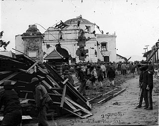
The 1902 Guatemala earthquake occurred on April 18 at 8:23 pm with a moment magnitude of 7.5 and a maximum Mercalli intensity of VIII (Severe). The rupture was initiated at a depth of 25 km (16 mi) and the duration was 1 to 2 minutes.
The 1717 Guatemala earthquake struck colonial Guatemala on September 29 with an estimated moment magnitude of 7.4, and a Mercalli intensity of approximately IX (Violent). The earthquake essentially destroyed much of the architecture of Antigua Guatemala, which was the colonial capital of Central America at the time. Over 3,000 buildings were ruined including many temples and churches. Such was the effect of the disaster that the authorities considered moving the headquarters to a settlement which was less prone to natural disasters.

The 1773 Guatemala earthquake struck colonial Guatemala on July 29 at 15:45 local time. It had an estimated epicentral magnitude of 7.5 Mi. It was part of a sequence that started in May that year. There were two strong foreshocks on June 11 and the mainshock was followed by numerous aftershocks which lasted until December 1773. The series of all these earthquakes is also referred to as the Santa Marta earthquake(s) as it had started on the feast day of Saint Martha.
The 1965 Oaxaca earthquake occurred in Mexico on August 23 at with a moment magnitude of 7.5. Five people were reported dead in Mexico City and one in Oaxaca. There was an anomalous change in seismic activities before the earthquake. There was a quiescent stage from late 1963 to mid-1964, and it was followed by a renewal of seismic activities before the main shock. This earthquake was a shallow thrust earthquake in the interplate subduction zone, in which the Cocos plate is subducting beneath the North American plate.
The 1953 Tumbes earthquake occurred on December 12 at near the border between Peru and Ecuador. The shock had a moment magnitude of 7.5, a maximum Mercalli Intensity of VIII (Severe), and occurred in the northwestern offshore area of Tumbes, Peru.
The 1942 Guatemala earthquake occurred at on August 6 and had ratings of 7.7 on the moment magnitude scale and 7.9 on the surface-wave magnitude scale. The epicenter was located off the southern coast of Guatemala, and it was one of the strongest earthquakes ever recorded there.
The 1942 Peru earthquake occurred on August 24 at and was located near the border of the departments of Ica and Arequipa, Peru. It had a magnitude of 8.2 or 8.4.
The February 2001 El Salvador earthquake occurred with a moment magnitude of 6.6 on 13 February at 14:22:05 UTC. The epicentre was 15 miles (30 km) E of San Salvador, El Salvador, at a depth of 10 km. At least 315 people were killed, 3,399 were injured, and extensive damage affected the area. Another 16,752 homes were damaged and 44,759 destroyed. The most severe damage occurred in the San Juan Tepezontes-San Vicente-Cojutepeque area, though it was felt throughout the country and in neighboring Guatemala and Honduras. Landslides occurred in many areas of El Salvador.
The 1839 Martinique earthquake occurred on the morning of January 11 with an estimated magnitude of 7.8 Ms , the largest in the Lesser Antilles since 1690. The maximum intensity of this earthquake was assigned IX on both the Mercalli and MSK intensity scales, which left the cities of Saint-Pierre and Fort Royal almost completely destroyed. Estimation on the number of human losses varies from 390 to 4,000 making this one of the deadliest earthquakes in the Caribbean.
An earthquake occurred on 26 August 2012 at 22:37 local time. The earthquake located off the coast of El Salvador measured 7.3 on the moment magnitude scale and had a focal depth of 16.0 kilometres (10 mi). No deaths were reported, however more than 40 people were injured when they were caught in a tsunami generated by the earthquake. Waves from the tsunami were unusually large for an earthquake of this size. The large waves were attributed to the earthquake's unique rupture characteristic. In addition to the absence of fatalities, damage caused by the earthquake and tsunami was minimal as a result of the sparse population around the affected region and the slow rupture characteristic of the event.

An earthquake occurred off the coast of the Alaska Peninsula on July 28, 2021, at 10:15 p.m. local time. The large megathrust earthquake had a moment magnitude of 8.2 according to the United States Geological Survey (USGS). A tsunami warning was issued by the National Oceanic and Atmospheric Administration (NOAA) but later cancelled. The mainshock was followed by a number of aftershocks, including three that were of magnitude 5.9, 6.1 and 6.9 respectively.
The 1965 San Salvador earthquake occurred at 04:01 in the morning on May 3, 1965. It had a moment magnitude of 5.9 and a maximum Mercalli intensity of VIII (Severe). The shock caused severe damage to El Salvador's capital city, San Salvador. The town of Ilopango, Soyapango, and Delgado was also hard hit. The earthquake was the most destructive to affect the city prior to the 1986 earthquake.
The 1959 Coatzacoalcos earthquake occurred at 02:25 local time on August 26 near the Mexican state of Veracruz. The earthquake measured 6.4 Mw at a depth of 21 km (13 mi), and had a maximum Modified Mercalli intensity of VIII (Severe). It had an epicenter immediately off the coast of Coatzacoalcos. The shallow back-arc thrust faulting earthquake damaged the cities of Acayucan, Coatzacoalcos, Jáltipan and Minatitlán. A total of 25 people died, including 10 from Jáltipan while a further 200 were injured. The Middle America Trench, a subduction zone that borders the southwestern coast of Mexico and Central America, accounts for much of the seismicity in Mexico. The eastern side of the country near the Gulf of Mexico rarely experiences large earthquakes although they have been recorded around the Veracruz area, where seismicity is higher compared to other parts of the gulf. Seismicity in the gulf is attributed to back-arc compression due to subduction.

The 1917 San Salvador earthquake occurred on June 7 at 18:55 local time near the Salvadoran capital. The hypocenter of the Mw 6.7 was at a shallow depth of 15 km (9.3 mi), and occurred along a shallow crustal fault near San Salvador. The earthquake caused significant destruction of the city and left approximately 1,050 dead. It was followed by an eruption on San Salvador that killed another 1,100. Only behind the earthquake of 1986, it is the second deadliest in El Salvador's history.
On 6 May 1951 EL Salvador was struck by an earthquake with a magnitude of 5.9–6.2 at 23:03 UTC. This was the first in a sequence that affected the area around Jucuapa over a period of a few days. The maximum felt intensity was VIII (Severe) on the Modified Mercalli Intensity Scale and it led to between 400 and 1,100 deaths.
