Guatemala City is the site of the native Mayan city of Kaminaljuyu in Mesoamerica, which was occupied primarily between 1500 BCE and 1200 CE. The present city was founded by the Spanish after their colonial capital, now called Antigua Guatemala, was destroyed by the devastating 1773 Santa Marta earthquake and its aftershocks.[8] It became the third royal capital of the surrounding Captaincy General of Guatemala; which itself was part of the larger Viceroyalty of New Spain in imperial Spanish America and remained under colonial rule until the nineteenth century.
In September 1821, Guatemala City was the site of the famous Act of Independence of Central America, which declared the independence of the region from the Spanish Empire. It was ratified and enacted on 15 September, now celebrated annually as Guatemala's independence day and called the Dias Patrios. For the next several decades, Guatemala City was the federation capital of the newly established and independent government of the United Provinces of Central America, which was later reorganized and renamed the Federal Republic of Central America.[9] In August 1847, Guatemala declared itself an independent republic, separate from the larger federation, and Guatemala City became its national capital.[10]
Guatemala City and the surrounding region were almost completely destroyed by the 1917–1918 Guatemala earthquakes and months of continued aftershocks. Reconstructions since have resulted in a more modern architectural landscape, including wider streets and a grid lay-out for new developments, inspired by post-18th century designs of architects in other national capital cities such as Paris, France and Washington, D.C.
Today, Guatemala City is the political, cultural, religious and economic center of the Republic of Guatemala and exerts a wide financial, commercial, and cultural influence on the Central America region and beyond, throughout Latin America.
Names
Guatemala City (Spanish: Ciudad de Guatemala) is known colloquially by Guatemalans as La Capital or Guate. Its formal name is Nueva Guatemala de la Asunción[11] (New Guatemala of the Assumption). The latter name is derived from the fact that it was a new Guatemala after the old one (La Antigua) was ruined by an earthquake. Also, Assumption is in honor of the Virgin of the Assumption, whose festivity is 15 August, the city's feast day.
Human settlement on the present site of Guatemala City began with the native indigenous Maya people, who built a large ceremonial center at Kaminaljuyu. This large Maya settlement, the biggest outside the Maya lowlands in the Yucatán Peninsula, of southeast Mexico, rose to prominence around 2,300 years ago, about 300 B.C. due to an increase in mining and trading of obsidian, a valuable commodity of volcanic glass (Igneous rock) for the Pre-Columbian American civilizations in Mesoamerica. Kaminaljuyu then mysteriously collapsed around A.D. 300 for as yet unknown historical causes.[12]
A series of devastating earthquakes in 1773 had left the old second Royal Spanish colonial / provincial capital city of La Antigua Guatemala, and surrounding area in ruins and unusable to the Imperial Spanish colonial authorities. During this period of the late 18th century after the move three years later in 1776 to the current site of modern Guatemala City, that the central plaza in the new town, with its premier landmark neo-classical style architecture of the immense Metropolitan Cathedral (officially named: Catedral Primada Metropolitana de Santiago), built 1782–1815, completed / dedicated 1871. Its the center of the country's Roman Catholic Church and its Archdiocese of Guatemala and the seat (chair) for the serving current Archbishop of Guatemala. Also erected in that post-1773 Santa Marta Earthquake was the massive regional colonial Royal Spanish government's Palace of the Captain-General, were constructed in the old second capital of the 1700s, now semi-ruined town Antigua Guatemala and preserved historic site, which later was partially repaired and maintained, even though the capital had been moved away to the current city in Emmita Valley. The old monumental palace served then as the headquarters for the colonial government regional jurisdiction of the Captaincy General of Guatemala, from its organization in 1542 to independence in 1821. Today it serves as the site for several current national government offices, national police, several tourism agencies along with galleries / exhibits of the National Museum of Guatemalan Art.
The subsequent decades in the 19th century saw the construction of some significant structures in the town, such as the monumental Carrera Theater in the 1850s, and the modern-day historic executive residence of the Casa Presidencial de Guatemala|Casa Presidencial de Guatemala (Presidential Palace of Guatemala) in the 1890s for the former and still occupied by the current President of the Republic. At this time, the capital city was expanding around the 30 de Junio Boulevard and elsewhere, unfortunately displacing native / indigenous peoples in the settlements on the peripheries of the growing city. The early 20th century series of earthquakes during the years of 1917–1918 destroyed many historic structures from the era of the late 18th and following 19th centuries of the first period of Guatemala City capital history, erected during the 144 years since the previous devastating tremors in the infamous Santa Marta Earthquake of 1773, (referred to previously further above), which destroyed the previous nearby Royal Spanish and colonial / provincial capital city of La Antigua Guatemala (now a historic site with preserved ruins).
A decade later, under former military General, then elected 21st President (later unfortunately becoming an authoritarian dictator) of Jorge Ubico (1878–1946, ruled 1931–1944). General / President Ubico after clinging to power for 13 years, was later overthrown in the Guatemalan Revolution of 1944, a democratic pivotal event in the nation's history that is still celebrated annually 80 years later in the country, alongside the earlier 15 September Independence Day of Central America from 1821.
In the subsequent 1930s decade with the worldwide Great Depression affecting many nations' economies and commerce / trade during the Ubico dictatorship era, however using public works projects such as a hippodrome and many new public buildings were constructed in the period. This was highlighted by the design and construction of the monumental National Palace (built 1939–1943, as an official residence and offices for the President of the Republic, renovated 2010 and now known as the National Palace of Culture, and used as a national museum).
Although slums that had formed with the major displacement of the city and region's population after the 1917–1918 series of earthquakes, continued to grow and spread around the edges of the capital city with the lack of civilized normal basic amenities and public services / utilities, such as fresh water piping, sewer drainage systems / filtration plants, electric power lines with paved / lighted streets and highways, etc.
Guatemala City continues to be subject to an unusual amount of natural and climate-related disasters, (especially recurring earthquakes) with the latest being the two disasters that struck simultaneously in May 2010: the eruption of the Pacaya volcano and, two days later, the torrential downpours from Tropical Storm Agatha of 2010.
Contemporary history
Zone 10 of Guatemala City
Guatemala City serves as the economic, governmental, and cultural center of the nation of Guatemala. The city also functions as Guatemala's main transportation hub, hosting an international airport, La Aurora International Airport, and serving as the origination or end points for most of Guatemala's major highways. The city, with its robust economy, attracts hundreds of thousands of rural migrants from Guatemala's interior hinterlands and serves as the main entry point for most foreign immigrants seeking to settle in Guatemala.
In addition to a wide variety of restaurants, hotels, shops, and a modern BRT transport system (Transmetro), the city is home to many art galleries, theaters, sports venues and museums (including some fine collections of Pre-Columbian art) and provides a growing number of cultural offerings. Guatemala City not only possesses a history and culture unique to the Central American region, it also furnishes all the modern amenities of a world class city, ranging from an IMAX Theater to the Ícaro film festival (Festival Ícaro), where independent films produced in Guatemala and Central America are debuted.
Plaza España at nightEvening view from a planeCayalá City[es], a new neighbourhood of Guatemala City with vernacular architectureZone 14 of Guatemala City
Guatemala City is located[13] in the mountainous regions of the country, between the Pacific coastal plain to the south and the northern lowlands of the Peten region.
The city's metropolitan area has recently grown very rapidly and has absorbed most of the neighboring municipalities of Villa Nueva, San Miguel Petapa, Mixco, San Juan Sacatepequez, San José Pinula, Santa Catarina Pinula, Fraijanes, San Pedro Ayampuc, Amatitlán, Villa Canales, Palencia, and Chinautla, forming what is now known as the Guatemala City Metropolitan Area.
The city is subdivided into 22 zones ("Zonas") designed by the urban engineering of Raúl Aguilar Batres, each one with its own streets ("Calles"), avenues ("Avenidas") and, sometimes, "Diagonal" Streets, making it pretty easy to find addresses in the city. Zones are numbered 1–25, with Zones 20, 22 and 23 not existing as they would have fallen in two other municipalities' territory.[14] Addresses are assigned according to the street or avenue number, followed by a dash and the number of metres it is away from the intersection.[15]
For example, the INGUAT Office on "7a Av. 1–17, Zona 4" is a building which is located on Avenida 7, 17 meters away from the intersection with Calle 1, toward Calle 2 in zone 4.
7a Av. 1–17, Zona 4; and 7a Av. 1–17, Zona 10, are two radically different addresses.
Short streets/avenues do not get new sequenced number, for example, 6A Calle is a short street between 6a and 7a.
Some "avenidas" or "Calles" have a name in addition to their number, if it is very wide; for example, Avenida la Reforma is an avenue which separates Zone 9 and 10, and Calle Montúfar is Calle 12 in Zone 9.
Calle 1 Avenida 1 Zona 1 is the center of every city in Guatemala.
Zone One is the Historic Center (Centro Histórico), lying in the very heart of the city, the location of many important historic buildings, including the Palacio Nacional de la Cultura (National Palace of Culture), the Metropolitan Cathedral, the National Congress, the Casa Presidencial (Presidential House), the National Library, and Plaza de la Constitución (Constitution Plaza, old Central Park). Efforts to revitalize this important part of the city have been undertaken by the municipal government.
Besides the parks, the city offers a portfolio of entertainment in the region, focused on the so-called Zona Viva and the Calzada Roosevelt, as well as four degrees North. Casino activity is considerable, with several located in different parts of the Zona Viva. The area around the East market is being redeveloped.
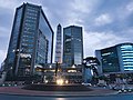
Within the financial district are the tallest buildings in the country, including: Club Premier, Tinttorento, Atlantis building, Atrium, Tikal Futura, Building of Finances, Towers Building Batteries, Torres Botticelli, Tadeus, building of the INTECAP, Royal Towers, Towers Geminis, Industrial Bank towers, Holiday Inn Hotel, Premier of the Americas, among many others to be used for offices, apartments, etc. Also included are projects such as Zona Pradera and Interamerica's World Financial Center.
One of the most outstanding mayors was the engineer Martin Prado Vélez, who took over in 1949, and ruled the city during the reformist presidents Juan José Arévalo and Jacobo Arbenz Guzman, although he was not a member of the ruling party at the time and was elected due his well-known capabilities. Of cobanero origin, married with Marta Cobos, he studied at the University of San Carlos; under his tenure, among other modernist works of the city, infrastructure projects included El Incienso bridge, the construction of the Roosevelt Avenue, the main road axis from East to West of the city, the town hall building, and numerous road works which meant the widening of the colonial city, its order in the cardinal points and the generation of a ring road with the first cloverleaf interchange in the city.[16]
In an attempt to control the rapid growth of the city, the municipal government (Municipalidad de Guatemala), headed by longtime Mayor Álvaro Arzú, has implemented a plan to focus growth along important arterial roads and apply Transit-oriented development (TOD) characteristics. This plan, denominated POT (Plan de Ordenamiento Territorial), aims to allow taller building structures of mixed uses to be built next to large arterial roads, and gradually decline in height and density moving away from such. It is also worth mentioning, that due to the airport being in the south of the city, height limits based on aeronautical considerations have been applied to the construction code. This limits the maximum height for a building, at 60 metres (200 feet) in Zone 10, up to 95 metres (312 feet) in Zone 1.[14]
Climate
Despite its location in the tropics, Guatemala City has a monsoon humid subtropical climate (KöppenCwa)[citation needed] due to its relatively high altitude which moderate the average temperatures. Guatemala City is generally very warm, almost springlike, throughout the course of the year.
It occasionally gets hot during the dry season, but not as hot and humid as in Central American cities at sea level. The hottest month is April. The rainy season extends from May to October, coinciding with the tropical storm and hurricane season in the western Atlantic Ocean and Caribbean Sea, while the dry season extends from November to April. The city can at times be windy, which also leads to lower ambient temperatures.
The city's average annual temperature ranges are 22–28°C (71.6–82.4°F) during the day and 12–17°C (53.6–62.6°F) at night; its average relative humidity is 82% in the morning and 58% in the evening; and its average dew point is 16°C (60.8°F).[17]
Four stratovolcanoes are visible from the city, two of them active. The nearest and most active is Pacaya, which at times erupts a considerable amount of ash.[19] These volcanoes lie to the south of the Valle de la Ermita, providing a natural barrier between Guatemala City and the Pacific lowlands that define the southern regions of Guatemala. Agua, Fuego, Pacaya, and Acatenango comprise a line of 33 stratovolcanoes that stretches across the breadth of Guatemala, from the Salvadorian border to the Mexican border.
Lying on the Ring of Fire, the Guatemalan highlands and the Valle de la Ermita are frequently shaken by large earthquakes. The last large tremor to hit the Guatemala City region occurred in the 1976, on the Motagua Fault, a left-lateral strike-slip fault that forms the boundary between the Caribbean Plate and the North American Plate. The 1976 event registered 7.5 on the moment magnitude scale. Smaller, less severe tremors are frequently felt in Guatemala City and environs.
Mudslides
Torrential downpours, similar to the more famous monsoons, occur frequently in the Valle de la Ermita during the rainy season, leading to flash floods that sometimes inundate the city. Due to these heavy rainfalls, some of the slums perched on the steep edges of the canyons that criss-cross the Valle de la Ermita are washed away and buried under mudslides, as in October 2005.[20] Tropical waves, tropical storms and hurricanes sometimes strike the Guatemalan highlands, which also bring torrential rains to the Guatemala City region and trigger these deadly mudslides.
Piping pseudokarst
2007 SinkholeThe 2010 sinkhole in Zona 2
In February 2007, a very large, deep circular hole with vertical walls opened in northeastern Guatemala City (14°39′2″N90°29′25″W / 14.65056°N 90.49028°W / 14.65056; -90.49028), killing five people. This sinkhole, which is classified by geologists as either a "piping feature" or "piping pseudokarst", was 100 metres (330ft) deep, and apparently was created by fluid from a sewer eroding the loose volcanic ash, limestone, and other pyroclastic deposits that underlie Guatemala City.[21][22] As a result, one thousand people were evacuated from the area.[23] This piping feature has since been mitigated by City Hall by providing proper maintenance to the sewerage collection system,[24] and plans to develop the site have been proposed. However, critics believe municipal authorities have neglected needed maintenance on the city's aging sewerage system, and have speculated that more dangerous piping features are likely to develop unless action is taken.[25]
It is estimated that the population of Guatemala City urban area is about 3 million.[26][27][28] The growth of the city's population has been robust, abetted by the mass migration of Guatemalans from the rural hinterlands to the largest and most vibrant regional economy in Guatemala.[29] Among inhabitants of Guatemala City, those of Spanish and Mestizo descent are the most numerous.[29] Guatemala City also has sizable indigenous populations, divided among the 23 distinct Mayan groups present in Guatemala. The numerous Mayan languages are now spoken in certain quarters of Guatemala City, making the city a linguistically rich area. Foreigners and foreign immigrants comprise the final distinct group of Guatemala City inhabitants, representing a very small minority among the city's denizens.[29]
Due to mass migration from impoverished rural districts wracked with political instability, Guatemala City's population has exploded since the 1970s, severely straining the existing bureaucratic and physical infrastructure of the city. As a result, chronic traffic congestion, shortages of safe potable water in some areas of the city, and a sudden and prolonged surge in crime have become perennial problems. The infrastructure, although continuing to grow and improve in some areas,[30] is lagging in relation to the increasing population of rural migrants, who tend to be poorer.[31]
Communications
Guatemala City is headquarters to many communications and telecom companies, among them Tigo, Claro-Telgua, and Movistar-Telefónica. These companies also offer cable television, internet services and telephone access. Due to Guatemala City's large and concentrated consumer base in comparison to the rest of the country, these telecom and communications companies provide most of their services and offerings within the confines of the city. There are also seven local television channels, in addition to numerous international channels. The international channels range from children's programming, like Nickelodeon and the Disney Channel, to more adult offerings, such as E! and HBO. While international programming is dominated by entertainment from the United States, domestic programming is dominated by shows from Mexico. Due to its small and relatively income-restricted domestic market, Guatemala City produces very little in the way of its own programming outside of local news and sports.
Economy and finance
Guatemala City, as the capital, is home to Guatemala's central bank, from which Guatemala's monetary and fiscal policies are formulated and promulgated. Guatemala City is also headquarters to numerous regional private banks, among them CitiBank, Banco Agromercantil, Banco Promerica, Banco Industrial, Banco GyT Continental, Banco de Antigua, Banco Reformador, Banrural, Grupo Financiero de Occidente, BAC Credomatic, and Banco Internacional.
By far the richest and most powerful regional economy within Guatemala, Guatemala City is the largest market for goods and services, which provides the greatest number of investment opportunities for public and private investors in all of Guatemala. Financing for these investments is provided by the regional private banks, as well as through foreign direct investment mostly coming from the United States. Guatemala City's ample consumer base and service sector is represented by the large department store chains present in the city, among them Siman, Hiper Paiz & Paiz (Walmart), Price Smart, ClubCo, Cemaco, Sears, and Office Depot.[citation needed]
Guatemala City is divided into 22 zones in accordance with the urban layout plan designed by Raúl Aguilar Batres. Each zone has its own streets and avenues, facilitating navigation within the city. Zones are numbered 1 through 25. However, numbers 20, 22 and 23 have not been designated to zones, thus these zones do not exist within the city proper.[14]
Paseo Cayalá, a new district with various landmarks
Transportation
TransmetroTransurbanoLa Aurora International Airport
Renovated and expanded, La Aurora International Airport lies to the south of the city center. La Aurora serves as Guatemala's principal air hub.
Public transport is provided by buses and supplemented by a BRT system. The three main highways that bisect and serve Guatemala start in the city (CA9 Transoceanic Highway – Puerto San Jose to Puerto Santo Tomas de Castilla –, CA1 Panamerican Highway – from the Mexican border to Salvadorian border – and to Peten). Construction of freeways and underpasses by the municipal government, the implementation of reversible lanes during peak rush-hour traffic, as well as the establishment of the Department of Metropolitan Transit Police (PMT), has helped improve traffic flow in the city. Despite these municipal efforts, the Guatemala City metropolitan area still faces growing traffic congestion.
A BRT (bus rapid transit) system called Transmetro, consisting of special-purpose lanes for high-capacity buses, began operating in 2007, and aimed to improve traffic flow in the city through the implementation of an efficient mass transit system. The system consists of five lines. It is expected to be expanded around 10 lines, with some over-capacity expected lines being considered for Light Metro or Heavy Metro.
Traditional buses are now required to discharge passengers at transfer stations at the city's edge to board the Transmetro. This is being implemented as new Transmetro lines become established. In conjunction with the new mass transit implementation in the city, there is also a prepaid bus card system called Transurbano that is being implemented in the metro area to limit cash handling for the transportation system. A new fleet of buses tailored for this system has been purchased from a Brazilian firm.
Guatemala City is home to ten universities, among them the oldest institution of higher education in Central America, the University of San Carlos of Guatemala. Founded in 1676, the Universidad de San Carlos is older than all North American universities except for Harvard University.
The other nine institutions of higher education to be found in Guatemala City include the Universidad Mariano Gálvez, the Universidad Panamericana, the Universidad Mesoamericana, the Universidad Rafael Landivar, the Universidad Francisco Marroquín, the Universidad del Valle, the Universidad del Istmo, Universidad Galileo, Universidad da Vinci, and the Universidad Rural. Whereas these nine named universities are private, the Universidad de San Carlos remains the only public institution of higher learning.
↑Resultados Censo 2018(PDF) (Report) (in Spanish). Instituto Nacional de Estadística Guatemala. December 2019. p.113. Archived(PDF) from the original on 15 August 2025. Retrieved 6 June 2025.
↑UNESCO World Heritage Centre. "Antigua Guatemala". UNESCO World Heritage Centre. Archived from the original on 7 January 2025. Retrieved 7 January 2025.
↑"MTU-VP Pacaya Volcano, Guatemala". Department of Geological and Mining Engineering and Sciences | Michigan Technological University. 1 June 1995. Archived from the original on 4 February 2009. Retrieved 8 July 2009.
Almengor, Oscar Guillermo (1994). "La Nueva Guatemala de la Asunción y los terremotos de 1917–18". Ciudad de Guatemala (in Spanish). Guatemala: Centro de estudios urbanos y regionales-USAC.
Bascome Jones, J.; Scoullar, William T.; Soto Hall, Máximo (1915). El Libro azul de Guatemala (in Spanish). Searcy & Pfaff. relato é historia sobre la vida de las personas más prominentes; historia condensada de la república; artículos especiales sobre el comercio, agricultura y riqueza mineral, basado sobre las estadísticas oficiales
Comisión para el Esclarecimiento Histórico (1999). "Atentados contra la libertad". Programa de Ciencia y Derechos Humanos, Asociación Americana del Avance de la Ciencia (in Spanish). IV, 2. Guatemala: memoria del silencio. Archived from the original on 22 May 2011. Retrieved 20 September 2014.
Comisión para el Esclarecimiento Histórico: Vol. IV (1999). "Atentados contra sedes municipales". Programa de Ciencia y Derechos Humanos, Asociación Americana del Avance de la Ciencia (in Spanish). Guatemala: memoria del silencio. Archived from the original on 6 May 2013. Retrieved 20 September 2014.
El Periódico (31 January 2012). "Quema de embajada española". elPeriódico (in Spanish). Archived from the original on 30 October 2013. Retrieved 8 October 2013.
González Davison, Fernando (2008). La montaña infinita;Carrera, caudillo de Guatemala (in Spanish). Guatemala: Artemis y Edinter. ISBN978-84-89452-81-7.
Municipalidad de Guatemala (August 2008a). "Paso a desnivel de Tecún Umán". Segmento cultural de la Municipalidad de Guatemala (in Spanish). Archived from the original on 24 February 2011. Retrieved 27 September 2014.
Museo Ixchel (2008). "Museo Ixchel". Museo Ixchel del traje indígena (in Spanish). Archived from the original on 2 February 2008. Retrieved 25 July 2009.
Population data (2012). "Guatemala population". Population data. Archived from the original on 26 December 2013. Retrieved 12 December 2012.
Prensa Libre (6 September 1980). "Avalancha terrorista en contra de la manifestación de mañana; poder público y transporte extraurbano blancos de ataque". Prensa Libre (in Spanish). Guatemala.
This page is based on this Wikipedia article Text is available under the CC BY-SA 4.0 license; additional terms may apply. Images, videos and audio are available under their respective licenses.


![Cayala City [es], a new neighbourhood of Guatemala City with vernacular architecture 05 Ciudad Cayala Front View.jpg](http://upload.wikimedia.org/wikipedia/commons/thumb/0/0d/05_Ciudad_Cayala_Front_View.jpg/250px-05_Ciudad_Cayala_Front_View.jpg)


