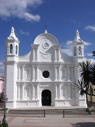
Santa Rosa de Copán is a municipality in Honduras. The city of Santa Rosa de Copán is the municipal seat and the departmental capital of the Honduran department of Copán. It is located approximately 1,150 metres (3,773 ft) above mean sea level.

Guatemala Department is one of the 22 departments of Guatemala. The capital is Guatemala City, which also serves as the national capital. The department consists of Guatemala City, its suburbs and other municipalities.
Guazacapán is a town located in Santa Rosa Department in south-west Guatemala. Guazacapán is also the name of the municipality in Santa Rosa Department around the town of Guazacapán. The municipality of Guazacapán covers an area of 130 km² with a population of 18,855, according to the 2018 census.

San Pedro Carchá, usually referred to as Carchá, is a town and a municipality in the Guatemalan department of Alta Verapaz. The municipality covers an area of 1,310 km2 and is situated at 1,282 m above sea level.
Santa Cruz Verapaz is a town and municipality in the Guatemalan department of Alta Verapaz. The municipality lies at an altitude of 1,406 metres above sea level. It has a population of 32,042 and covers an area of 99.9 km². The annual festival is May 1-May 5.
Nentón is a town and municipality in the Guatemalan department of Huehuetenango. Its territory extends 717 km2 with a population of 45,679. It became a municipality on December 5, 1876 and was formerly known as San Benito Nentón. The population speaks Spanish and Chuj.

San Pedro Soloma is a town and municipality of Huehuetenango, a department of Guatemala. It is located in the Sierra de los Cuchumatanes at 2,300 m above sea level. The municipality covers a total area of 264 km2 with elevations ranging from 1,900 m to 3,500 m. Its population of 49,030 is spread over the town of Soloma, 19 villages and 50 smaller rural communities (caserios).

San Juan Comalapa is a town, with a population of 32,312, and a municipality in the Chimaltenango department of Guatemala.
San Martín Jilotepeque is a town, with a population of 10,812, and a municipality in the Chimaltenango department of Guatemala. It was the site of a bus accident in 2013.
Yepocapa, also known as San Pedro Yepocapa, is a town with a population of 17,021, and a municipality in the Chimaltenango department of Guatemala. It is located at the base of Volcán de Fuego, which has destroyed the town several times, most recently on 15 October 1974.

San José Pinula is a town, with a population of 67,327, and a municipality in the Department of Guatemala in the Republic of Guatemala in Central America. It is located 21 kilometers (13 mi) from the capital, Guatemala City. The city was established in 1886 as Villorio San José. The city is surrounded by mountains. Until a few years ago, the economy was based on the growing of corn, as well as some vegetables such as guisquil, chayote or pataste. However, the growth of Guatemala City in recent years has transformed farmland into suburban neighborhoods. Golf courses, such as Hacienda Nueva Country Club which used to be a convent in the 16th century and Alta Vista Country Club, both considered world-class, are now in and around San José Pinula.
San Raymundo is a town, with a population of 15,447, and a municipality in the Guatemala department of Guatemala. The municipality has a population of 31,605 and cover an area of 110 km2. It consists of 10 outlying villages and several smaller urbanized areas. San Raymundo is highly populated by both Ladino and Indigenous people.
San Pedro Pinula is a town and municipality in the Jalapa department of Guatemala. There is a cathedral in the town.

Zunil is a town and municipality in the Quetzaltenango department of Guatemala with a surface area of 80 square kilometres (31 sq mi). The town of Zunil is located 9 kilometres (5.6 mi) from the city of Quetzaltenango, on the bank of the Salamá River. Zunil has an altitude of approximately 2,075 metres (6,808 ft) above mean sea level. The population of the municipality, which is 100% indigenous, was 14,118 at the 2018 census. The inhabitants speak Kʼicheʼ and Spanish. There are thermal baths with volcanic water around the town, for example Fuentes Georginas and Almolonga.
Olintepeque is a town, with a population of 31,545, and a municipality in the Quetzaltenango department of Guatemala, not far from the city of Quetzaltenango. It is located on the Xekik'el River.

San Juan Ostuncalco, is a town, with a population of 20,763, and a municipality in the Quetzaltenango department of Guatemala. Beside Spanish, local people speak the Mam language.

Salcajá is a town and municipality in Quetzaltenango department of Guatemala.
San Cristóbal Cucho is a town and municipality in the San Marcos department of Guatemala.It was found on 11 October 1825. It was annexed to San Pedro Sacatepéquez, in 1935, but it was named a municipality again on 12 July 1945.
San Pablo Jocopilas is a town, with a population of 16,872, and a municipality east-northeast of Samayac and west of highway CA 2 in the Suchitepéquez department of Guatemala, located 8 km from Mazatenango, which is the department's capital. The Colonial Church was chosen as one of the seven most wonderful in Guatemala in a contest run by the Industrial Bank. San Pablo Jocopilas also boasts other monuments, such as the centenary clock of Chocolá, built in 1800. The commune is located along the banks of the Ixtacapa River, which is a popular tourist spot during the holidays.
Santa Catarina Mita is a town, with a population of 14,520, and a municipality in the Jutiapa department of Guatemala. The municipality cover an area of 207 km2 and has a population of 28,983.


