Roseau

Last updated

Roseau
City
Roseau Dominica.jpg
Dominica, Karibik - Roseau - Our Lady of Fair Haven Cathedral - panoramio.jpg
Dominica Museum (40023442143).jpg
Parliament Building (32058789097).jpg
Baobab and bus.JPG
Top: Roseau skyline; Middle: Cathedral of Our Lady of Fair Haven of Roseau, Dominica Museum; Bottom: Dominica Parliament House, Dominica Botanical Gardens
Nickname: 
Town
Dominica location map.svg
Red pog.svg
Roseau
Roseau
Coordinates: 15°18′05″N61°23′18″W / 15.301389°N 61.388333°W / 15.301389; -61.388333
Country Dominica
Parish Saint George
Government
  TypeLocal government: Roseau City Council established 1890s
  His Worship MayorCecil Joseph
  MP – Roseau CentralHon. Norris Prevost
Area
  Total2.1 sq mi (5.4 km2)
Elevation
141 ft (43 m)
Population
 (2011) [1]
  Total14,725
  Density7,100/sq mi (2,700/km2)
Time zone UTC–4 (AST)
Area code +1 767

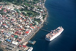
Roseau (Dominican Creole: Wozo) is the capital and largest city of Dominica, with a population of 14,725 as of 2011. [1] It is a small and compact urban settlement, in the Saint George parish and surrounded by the Caribbean Sea, the Roseau River and Morne Bruce. Built on the site of the ancient Island Carib village of Sairi, it is the oldest and most important urban settlement on the island of Dominica.

Contents

It is on the west (leeward) coast of Dominica and has a combination of modern and colonial French architecture.

Roseau is Dominica's most important port for foreign trade. Some exports include bananas, bay oil, vegetables, grapefruit, oranges, and cocoa. The service sector is also a large part of the local economy. There are several private institutions registered in Dominica, like Ross University, international university for graduate studies, All Saints University, New World University, Western Orthodox University.

There is a prominent diocese called Roman Catholic Diocese of Roseau.

History

Aerial photo of Roseau Roseau from the plane from Guadeloupe.jpg
Aerial photo of Roseau

The city of Roseau sits on an alluvial fan formed hundreds of years ago as the Roseau River meandered across the area from what is now known as Newtown to its current location. Over the last 2,000 years, Amerindians migrating through the islands settled the area attracted by the nearby river. With the arrival of the Europeans in the 16th and 17th centuries, a small settlement was established by the French who, in their tradition of naming places after what they found there, used their name for the river reeds that grew along the banks. A plan was created for the settlement that mirrored examples in France where streets extended from a central point – what is today the Old Market – and spread out to the rest of the settlement.

Conflict raged between the French and the British over the area on several occasions. In 1699, the French built a fort to protect Roseau. In 1770, the British built Fort Young in place of the previous fort. [2] [3] In 1778, the French invaded Dominica, capturing Fort Young and Roseau and taking control of the island. [4] In 1784, Dominica was returned to British control under the Treaty of Paris. [4]

By the late 18th and early 19th centuries, the British set out plans for the city that included fortifications and government structures, the grid street system, and blocks and new urban areas to the north and south, known today as Potter's Ville and Newtown. Goodwill was established in the 1950s and Bath Estate in the early 1980s. Since then several new semi-urban settlements – such as Stock Farm, Castle Comfort, and Wall House – have been constructed around the existing ones. Some older settlements like Fond Cole and Canefield nowadays belong to the semi-urban area around Roseau.

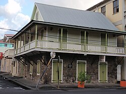
The French influence can still be seen today, however, in its architecture and crooked streets that extend from the Old Market Plaza. Examples of the English influence is evident in architecture and street names. [5]

Climate and scenery

Roseau's Bay Front area Roseau (Dominica).jpg
Roseau's Bay Front area

Roseau's nearby scenery (mostly in its so-called valley) includes Boiling Lake, 10.5 km (6.5 mi) east, in the Morne Trois Pitons National Park, waterfalls, thermal springs, and scenic plateaus.

Morne Bruce provides panoramic views of most of downtown Roseau and north toward Woodbridge Bay deepwater port and Fond Cole. From Morne Bruce there are views of the Botanic Gardens at its base as well as the Caribbean Sea which look quite spectacular when cruise liners are in port.

Roseau's climate is a tropical monsoon climate, featuring relatively constant temperatures throughout the year with average high temperatures generally between 28 and 31 °C (82.4 and 87.8 °F) and average low temperatures between 19 and 23 °C (66.2 and 73.4 °F). Rainfall is common throughout the year, with the city seeing an annual average nearly 1,800 millimetres or 70 inches. Roseau features a noticeably drier stretch from February through April, though each of these months on average sees at least 45 millimetres or 1.8 inches of rain.

Climate data for Roseau (Canefield Airport) 1982-2011
MonthJanFebMarAprMayJunJulAugSepOctNovDecYear
Record high °C (°F)33
(91)
34
(93)
36
(97)
36
(97)
36
(97)
36
(97)
35
(95)
35
(95)
36.3
(97.3)
37
(99)
35
(95)
34
(93)
37
(99)
Mean daily maximum °C (°F)29.5
(85.1)
29.5
(85.1)
30.1
(86.2)
30.9
(87.6)
31.8
(89.2)
31.8
(89.2)
31.5
(88.7)
31.8
(89.2)
31.7
(89.1)
31.5
(88.7)
31.1
(88.0)
30.2
(86.4)
31.0
(87.7)
Daily mean °C (°F)25.7
(78.3)
25.6
(78.1)
26.1
(79.0)
26.9
(80.4)
27.8
(82.0)
28.1
(82.6)
28.0
(82.4)
28.0
(82.4)
27.9
(82.2)
27.6
(81.7)
27.1
(80.8)
26.2
(79.2)
27.1
(80.8)
Mean daily minimum °C (°F)21.8
(71.2)
21.6
(70.9)
22.0
(71.6)
22.9
(73.2)
23.9
(75.0)
24.5
(76.1)
24.5
(76.1)
24.2
(75.6)
23.9
(75.0)
23.7
(74.7)
23.2
(73.8)
22.3
(72.1)
23.2
(73.8)
Record low °C (°F)16
(61)
17
(63)
17
(63)
18
(64)
19
(66)
20
(68)
21
(70)
21
(70)
20
(68)
18
(64)
18
(64)
17
(63)
16
(61)
Average rainfall mm (inches)108.3
(4.26)
62.1
(2.44)
49.0
(1.93)
54.8
(2.16)
92.0
(3.62)
159.5
(6.28)
251.4
(9.90)
244.3
(9.62)
253.7
(9.99)
188.2
(7.41)
194.2
(7.65)
102.2
(4.02)
1,759.7
(69.28)
Average relative humidity (%)71686564646772737173747270
Mean monthly sunshine hours 198.9200.6227.3244.9243.2227.7231.2240.4212.2219.5194.0189.52,629.4
Source 1: Dominica Meteorological Services [6]
Source 2: NOAA (sun 1961–1990), [7] BBC Weather [8]

Architecture

The central district of Roseau is tightly packed with small and large houses and even larger modern concrete structures. There is little green or open space in the city; there is even less today, as many of the courtyards that were once commonplace are giving way to office space. The district is, however, framed in every direction by natural elements. The sea and the river provide water elements while the Botanical gardens and the Government House gardens frame the city with green space. These elements are rare in the Caribbean. No other centre in the region has such extensive botanical gardens with such central location, and the Roseau River is among the largest that flow through any Caribbean capital.

The urban structure of Central Roseau is based on an irregular grid system of miniature proportions, making it a highly illegible city. Even though the grid area is not extensive, it is relatively easy for a visitor to get lost. The grid area has some 80 blocks in an area of 30 hectares (74 acres). In comparison, the grid areas of Kingstown and Castries — capitals of Saint Vincent and Saint Lucia — have some 50 and 60 blocks in the areas of over 40 hectares (99 acres). The average block size in Central Roseau is thus some ⅓ hectare (1 acre), i.e., about half of the figure of Central Kingstown.

There are some fine examples of West Indian architecture in Roseau. The ones that stand out the most are the French Colonial style and the vernacular form. Much of the French influence can be found along King George V Street. Around the city there are good examples of the English influence in large colonial town houses and colonial public/government buildings.

Roseau's French Quarter Roseau in the morning.jpg
Roseau's French Quarter

The churches in Roseau are fine examples of Europe in Dominica with a bit of creolization. The Roman Catholic Cathedral stands prominent in Gothic Romanesque revival and the Anglican Church on Victoria Street in Georgian style.

City life

Video showing activity at Farmers Market in downtown Roseau

Because of the suburban sprawl, few people live in Central Roseau, but more of them commute daily. Motorized vehicles pour into the central district introducing a mode of point-to-point interaction in an environment that was created for multiple use. As elders said, first there were no streets but just a space between the buildings. The streets of Roseau, and especially those of its central district, are not only ways to move from place to place but they are places themselves. They are used as gardens, playing fields, and social meeting places.

Street scene in Roseau Roseau street scene.jpg
Street scene in Roseau

The Botanical Gardens on the fringes of the central district are mostly used by children.

Sports and recreation

In Roseau, there are many opportunities for recreation. Many people seek the tranquility and cool of the Botanical Gardens as a getaway on Sunday afternoons and at lunch. It is a popular venue for local cricket matches and sports training. Football is popular; there are several pitches throughout the city (at Newtown, Potters Ville, and Bath Estate), as well as in the sports stadium at Windsor Park.

Windsor Park Windsor Park Roseau Dominica.JPG
Windsor Park

Sporting facilities and infrastructure

There are dedicated sports facilities around the city. Private tennis courts are on High Street; netball and basketball courts abound in the major high schools. These are complemented by community facilities at Goodwill. A dedicated netball and basketball stadium is at Stockfarm near the Dominica State College.

In 2007, Windsor Park, a cricket stadium which is also home to the Dominica national football team, was completed with a donation of EC$33 million from the government of the People's Republic of China.

Elsewhere it is not uncommon to find that a section of the street, sidewalk or the beach has been adapted for makeshift games of cricket or football.

Other popular sports include netball, basketball, rounders and (to a much lesser extent) tennis.

Accommodations and infrastructure

There are no world-famous hotel chains in the city. The most famous is the Fort Young Hotel. [9] In addition there are several small family owned establishments in and on the outskirts of Roseau.

Dominica Broadcasting Corporation, the national radio station, and two private radio stations are in the capital.

Non-governmental organizations

Roseau is home to service clubs including, Kiwanis, Rotary and Lions. There are other organizations such as the local humane society and conservation society. ChildFund International USA has an office in Roseau from where it runs its child centered development programs for Dominica and Saint Vincent.

The Dominica Association of Industry and Commerce, Waitukubuli Ecological Foundation, Dominica Tourism Association and others are based in the city.

The city is home to several labour organizations including the Dominica Amalgamated Workers' Union, the Dominica Public Service Union, the Dominica Trade Union, the National Workers' Union and the Waterfront and Allied Workers' Union.

Transportation

As the most important town on the island and hub of all business activity, the city is a central point of the road networks on the island. It is an important link between northern, eastern, and southern bound traffic.

Roseau is served by Canefield Airport, a nearby small aircraft airport that provides direct links to nearby islands, as well as the larger Douglas–Charles Airport to the north. The ferry terminal provides direct links to the neighbouring Guadeloupe to the north and Martinique and St. Lucia to the south.

There are no rail or subway systems.

Education

Roseau has been the historical centre of education on the island. There are six secondary schools in the city as well as eight primary schools. A community college, the Dominica State College, is in Roseau. There are two private medical schools, All Saints School of Medicine and Ross University School of Medicine, and a private university, Western Orthodox University.

Embassies and consulates

Several embassies are in the city. They include the Brazilian, the Chinese, the Cuban, and the Venezuelan embassies, with a couple of other consulates around the city.

Notable people

See also

Related Research Articles

<span class="mw-page-title-main">Geography of Dominica</span> Geography of the island country of Dominica

Dominica is an island in the Caribbean Sea, located about halfway between the French islands of Guadeloupe and Martinique. Its coordinates are 15 25 N, 61 20 W. It is known as "The Nature Island of the Caribbean" due to its spectacular, lush, and varied flora and fauna, which is protected by an extensive natural park system. It is the fourth largest island in the Eastern Caribbean with a population of people mainly of African descent.

<span class="mw-page-title-main">Basseterre</span> Capital of Saint Kitts and Nevis

Basseterre is the capital and largest city of Saint Kitts and Nevis with an estimated population of 14,000 in 2018. Geographically, the Basseterre port is located at 17°18′N62°44′W, on the south western coast of Saint Kitts Island, and it is one of the chief commercial depots of the Leeward Islands. The city lies within Saint George Basseterre Parish.

<span class="mw-page-title-main">Morne Diablotins</span> Mountain in Dominica in the Lesser Antilles

Morne Diablotins is the highest mountain in Dominica, an island-nation in the Caribbean Lesser Antilles. It is the second highest mountain in the Lesser Antilles, after La Grande Soufrière in Guadeloupe. Morne Diablotins is located in the northern interior of the island, about 24 kilometres (15 mi) north of Dominica's capital Roseau and about 10 kilometres (6.2 mi) southeast of Portsmouth, the island's second-largest town. It is located within Morne Diablotin National Park.

Carib Aviation was an airline based in Antigua and Barbuda.

<span class="mw-page-title-main">Saint David Parish, Dominica</span> Parish in Dominica

Saint David is one of Dominica's ten administrative parishes, located on the eastern side of the island. It is bordered by St. Andrew to the north; St. Joseph, St. Paul and St. George to the west; and St. Patrick to the south. With that, it’s bordered by five other parishes, more than any other one in Dominica. It has an area of 131.6 km² (50.8 mi²), and has a population of 6,789.

<span class="mw-page-title-main">Saint George Parish, Dominica</span> Parish in Dominica

Saint George is one of Dominica's 10 administrative parishes. It is bordered by Saint Paul and part of the Boeri River, Saint David and Saint Patrick, Saint Luke.

<span class="mw-page-title-main">Saint John Parish, Dominica</span> Parish in Dominica

Saint John is one of Dominica's 10 administrative parishes. It is bordered by St. Andrew to the east, and St. Peter and the Espagnole River to the south. It has an area of 59 km² (22.78 mi²).

<span class="mw-page-title-main">Portsmouth, Dominica</span> Town in Saint John Parish, Dominica

Portsmouth is the second largest town in Dominica, with 3,630 inhabitants. It is located on the shore of a natural Harbor, Prince Rupert Bay, in Saint John Parish on the north-west coast of Dominica. The area was called Ouyouhao by the Kalinago and Grand Anse by the French. The Indian River is Portsmouth’s southern border and Cabrits National Park is located on a peninsula to the north of town.

Grand Bay, known officially as Berekua or Berricoa, is a village in the south of Dominica. It has a population of 2,288 as of 2010, and is the largest settlement in St. Patrick Parish.

Canefield is a town located on the west coast of Dominica, north of Roseau and south of Massacre, overlooking Pringle's Bay. The largest settlement in St. Paul Parish, it has a population of 2,803. It is home to an industrial estate with Harris Paints Dominica Ltd., a branch of the Jehovah's Witnesses, the Old Mill Cultural Center and Museum as well as the island's second airport. Neighboring locales include Cochrane, Checkhall, Massacre and Fond Colé.

<span class="mw-page-title-main">Dominica</span> Country in the Caribbean

Dominica, officially the Commonwealth of Dominica, is an island country in the Caribbean. The capital, Roseau, is located on the western side of the island. It is geographically situated as part of the Windward Islands chain in the Lesser Antilles archipelago in the Caribbean Sea. Dominica's closest neighbours are two constituent territories of the European Union, the overseas departments of France, Guadeloupe to the northwest and Martinique to the south-southeast. Dominica comprises a land area of 750 km2 (290 sq mi), and the highest point is Morne Diablotins, at 1,447 m (4,747 ft) in elevation. The population was 71,293 at the 2011 census.

<span class="mw-page-title-main">Outline of Dominica</span> Overview of and topical guide to Dominica

The following outline is provided as an overview of and topical guide to Dominica:

Air Guadeloupe was a small French international airline with its head office in Les Abymes, Guadeloupe, France. At one time, it was on the property of Le Raizet Airport. Later it was located in the Immeuble Le Caducet.

<span class="mw-page-title-main">Air Martinique</span>

Air Martinique was an airline based in the island of Martinique in the Lesser Antilles in the Caribbean. Its head office was on the grounds of Fort-de-France Airport, now Martinique Aimé Césaire International Airport, in Le Lamentin.

<span class="mw-page-title-main">Index of Dominica-related articles</span>

The following is an alphabetical list of topics related to the nation of Dominica.

<span class="mw-page-title-main">Dominica Botanical Gardens</span>

Dominica Botanic Gardens is located on the Caribbean island-nation of Dominica, in the capital of Roseau. Once known as one of the finest botanical gardens in the region, it was severely damaged by Hurricane David in 1979. Following restoration efforts, it remains a focus of cultural life in Roseau, and a center of conservation research on Dominica.

<span class="mw-page-title-main">Tropical Storm Erika</span> Atlantic tropical storm in 2015

Tropical Storm Erika was one of the deadliest and most destructive natural disasters in Dominica since Hurricane David in 1979. The fifth named storm of the 2015 Atlantic hurricane season, Erika developed from a westward-moving tropical wave while well east of the Lesser Antilles. Hostile conditions, including dry air and wind shear, inhibited significant development, and Erika failed to acquire sustained winds beyond 50 mph (80 km/h). Contrary to predictions of a northwesterly recurvature, the cyclone persisted on a westerly course and passed through the Leeward Islands and emerged over the Caribbean Sea on August 27. Erika succumbed to adverse conditions the following day, dissipating as a tropical cyclone near the Dominican Republic. The remnant system persisted for several more days, moving into the northeastern Gulf of Mexico, before dissipating over Georgia on September 3.

<span class="mw-page-title-main">Morne Bruce</span>

Morne Bruce is a hillside enclave located in Roseau, Dominica. It offers a panoramic view of the city and the Caribbean Sea beyond. The site was once home to the military garrison that protected Roseau. Remains of the original barracks and officers' quarters can still be seen today. One of the old cannons (non-operational) is still located at the site, near a giant cross that was erected in the 1920s. Morne Bruce is accessible by road or via Jack's Walk, a trail that begins in the Dominica Botanical Gardens.

Fort Young was a major military installation on the Caribbean island of Dominica. It was built by the British in 1770. The fort was named for William Young, the island's first British governor. Today, only ruins remain of the fort, and the site is the location of the Fort Young Hotel.

References

  1. 1 2 "2011 Population and Housing Census – preliminary results" (PDF). Central Statistical Office (Dominica). Retrieved 24 October 2017.{{cite journal}}: Cite journal requires |journal= (help)
  2. About Dominica: Nature Island of the Caribbean : a Detailed Tourism-oriented Guide to Dominica. Voice Publishing Company. 1981. p. 4.
  3. Gravette, Andrew Gerald (2000). Architectural heritage of the Caribbean: an A-Z of historic buildings. Signal Books. p. 168. ISBN   978-1-902669-09-0 . Retrieved 22 June 2011.
  4. 1 2 Boromé, Joseph A. (1969). "Dominica during French Occupation, 1778-1784". The English Historical Review. 84 (330): 36–58. doi:10.1093/ehr/LXXXIV.CCCXXX.36. ISSN   0013-8266. JSTOR   562321.
  5. Niko Lipsanen, Naturalistic and existential realms of place in Roseau, Dominica. University of Helsinki, Department of Geography 2001.
  6. "CLIMATOLOGY FOR CANEFIELD AIRPORT (1982-2011)" (PDF). Dominica Meteorological Services. December 2012. Archived (PDF) from the original on 22 December 2020. Retrieved 22 December 2020.
  7. "Climate Normals for Melville Hall Airport 1961–1990". National Oceanic and Atmospheric Administration. Retrieved 28 February 2013.
  8. "Average Conditions Roseau, Dominica". BBC Weather. Retrieved 28 February 2013.
  9. "Fort Young Hotel Best Hotel Dominica | Fort Young Hotel | Caribbean". www.fortyounghotel.com.

15°18′05″N61°23′18″W / 15.30139°N 61.38833°W / 15.30139; -61.38833