Related Research Articles

The House of Assembly is the legislature of Dominica. It is established by Chapter III of the Constitution of Dominica, and together with the President of Dominica constitutes Dominica's Parliament. The House is unicameral, and consists of twenty-one Representatives, nine senators, and the Attorney General as an ex officio member. The Speaker of the House becomes the thirty-second member if chosen from outside the membership of the House.
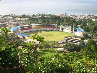
Windsor Park is a multi-purpose stadium in Roseau, Dominica. It serves as the country's national stadium and is used mostly for cricket and association football matches. Other uses have included the World Creole Music Festival, the Finals of the Calypso Competition and the Miss Dominica pageant.

Portsmouth is the second largest town in Dominica, with 3,630 inhabitants. It is located on the shore of a natural Harbor, Prince Rupert Bay, in Saint John Parish on the north-west coast of Dominica. The area was called Ouyouhao by the Kalinago and Grand Anse by the French. The Indian River is Portsmouth’s southern border and Cabrits National Park is located on a peninsula to the north of town.
La Plaine is a village located on the eastern side of the island of Dominica. It has a population of 1,288, and is the second-largest settlement in Saint Patrick Parish.
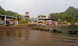
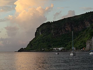
Soufrière is a village on the southwest coast of Dominica. It is the capital of Saint Mark Parish and has a population of 1,416 people.
Wotten Waven is a village in Dominica's Roseau Valley. It has a population of 226 people.

Saint Joseph is the chief settlement of Dominica's St. Joseph Parish. Its population is 2,029.

Castle Bruce is a village on the east coast of Dominica. It is the largest settlement in St. David Parish, with a population of 1,339.
Paix Bouche is a village in northern Dominica. It has a population of 306, and has one of the island's steepest roads. The name comes from the local Creole expression meaning "shut your mouth".

Pointe Michel is a small town on the southwest coast of Dominica. It is located to the south of the capital, Roseau.
Rosalie is a village in Dominica. It is located in Saint David Parish at the northern end of Rosalie Bay, on the central east coast of the island, close to the mouth of the Rosalie River.

Massacre is a town in Saint Paul Parish, Dominica, with about 1,200 inhabitants. It is located on the central west coast of the island, to the north of the capital, Roseau, on the Massacre River.
Bataka is a small town in Dominica. It is located in the northeast of the island, between Pagua Bay and Salybia.
Pont Cassé is situated in the Saint Paul Parish in Dominica. It is located almost in the middle of Dominica, close to Belles Village northeast of the national capital, Roseau, and close to Morne Trois Pitons, the mountain which dominates the southern center of the country. As of 2006 it has a population of 100.
Castle Comfort is a community in Saint George Parish, Dominica. 789 inhabitants live there and in neighbouring Wall House.
Voisey's Bay is a bay of the Atlantic Ocean in Labrador, Canada. The bay is located 38 kilometres (24 mi) south of the community of Nain. The bay is heavily indented with numerous inlets and islands and is extremely rocky. It is the site of the Voisey's Bay Mine.
Coulibistrie is a village on the west coast of Dominica, in the northwest corner of Saint Joseph Parish. It is between the villages of Colihaut to the north and Morne Rachette to the south. It extends inland from the coast within a deep valley, along both banks of the Coulibistrie River. The village is primarily residential with few businesses. Many of the houses are built directly atop or adjoining the numerous large boulders that litter the valley along its base.

The Kalinago Territory, previously known as the Carib Reserve or Carib Territory (outdated/derogatory), is a 3,700-acre (15 km2) district in the Caribbean island country of Dominica. It was established for the Indigenous Kalinago people who inhabited the region prior to European colonization and settlement.

Morne Rachette or Morne Raquette is a village on the west coast of Dominica, in the northwest corner of Saint Joseph Parish. It is located on the slopes of Morne Jalousie, above Coulibistrie to its immediate north and Batalie Bay. The village of Salisbury is south of Morne Rachette.
Picard is a community on the northwest side of Dominica. It is part of Portsmouth, Dominica.
References
- Crask, Paul (2007), Dominica, England: Bradt Travel Guides, p. 137, ISBN 1-84162-217-6
15°29′25″N61°15′13″W / 15.49028°N 61.25361°W
For the definition of town, village, etc see Settlements in Dominica. | |
| Towns |
|
| Villages |
|
| | This Dominica location article is a stub. You can help Wikipedia by expanding it. |
Salybia is a song from the Trinidadian rock band Cabezon.