
The Kalinago, also called Island Caribs or simply Caribs, are an Indigenous people of the Lesser Antilles in the Caribbean. They may have been related to the Mainland Caribs (Kalina) of South America, but they spoke an unrelated language known as Kalinago or Island Carib. They also spoke a pidgin language associated with the Mainland Caribs.
Saint David is one of Dominica's ten administrative parishes, located on the eastern side of the island. It is bordered by St. Andrew to the north; St. Joseph, St. Paul and St. George to the west; and St. Patrick to the south. With that, it's bordered by five other parishes, more than any other one in Dominica. It has an area of 131.6 km2 (50.8 mi2), and has a population of 6,789.
La Plaine is a village located on the eastern side of the island of Dominica. It has a population of 1,288, and is the second-largest settlement in Saint Patrick Parish.

Scotts Head is a village on the southwest coast of Dominica, in Saint Mark Parish. In 2001, its population was 721. Predominantly a fishing village, Scotts Head overlooks Soufrière Bay, which is protected as the Soufrière Scotts Head Marine Reserve. It is also a popular snorkelling and diving site for tourists.

Hampstead is a village in northeastern Dominica. Along with Bense, the area has a population of 495, and was used as a filming location for 2006's Pirates of the Caribbean: Dead Man's Chest.
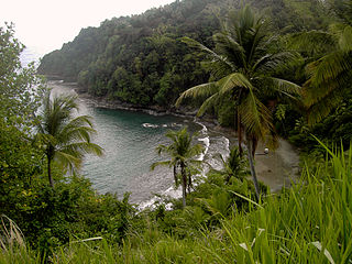
Rosalie is a village in Dominica. It is located in Saint David Parish at the northern end of Rosalie Bay, on the central east coast of the island, close to the mouth of the Rosalie River.

Calibishie is a village in Dominica, located on the north-east coast of the island, immediately to the east of the village of Hampstead. The Calibishie Coast Travel Area is thought by many to be the most scenic and unspoiled region of Dominica. The Calibishie coast is one of the few areas in the world where the distance from the seashore to rain forest is little more than a mile. Calibishie is home to Dominica's Batibou, Hampstead, Hodges, Point Baptiste, Turtle and Woodford Hill Beaches.

Massacre is a town in Saint Paul Parish, Dominica, with about 1,200 inhabitants. It is located on the central west coast of the island, to the north of the capital, Roseau, on the Massacre River.
Pont Cassé is situated in the Saint Paul Parish in Dominica. It is located almost in the middle of Dominica, close to Belles Village northeast of the national capital, Roseau, and close to Morne Trois Pitons, the mountain which dominates the southern center of the country. As of 2006 it has a population of 100.
Good Hope is a small fishing farming community located on the east coast of Dominica. The community is home to about 500 residents. The community is mainly managed by a Resource Centre Management Committee, which oversees projects of development, the functioning of the community's resource centre and also the overall well-being of the community.
Penville or Pennville is a village in Dominica's Saint Andrew Parish. The community is situated just north of Vieille Case, and has a population of 524.
Thibaud is a village on the northern coast of Dominica, part of Saint Andrew Parish. It has a population of approximately 500. Located near Vieille Case, Thibaud's main industries are fishing and farming.
The Crayfish River is a river in Dominica.
The Massacre River is a river on the Caribbean island of Dominica.

The Pagua River is one of the longest rivers on the Caribbean island of Dominica. It originates in the D'Leau Gommier area of the Central Forest Reserve, where it shares the same watershed as the Layou River. The Pagua flows northeastward, forming the western boundary of the Carib Territory. It empties into the Atlantic Ocean in Pagua Bay, on Dominica's east coast.

The Kalinago Territory, previously known as the Carib Reserve or Carib Territory (outdated/derogatory), is a 3,700-acre (15 km2) district in the Caribbean island country of Dominica. It was established for the Indigenous Kalinago people who inhabited the region prior to European colonization and settlement.
The Capture of Saint Vincent was a French invasion that took place between 16 and 18 June 1779 during the American Revolutionary War. A French force commander named Charles-Marie de Trolong du Rumain landed on the island of Saint Vincent in the West Indies and quickly took over much of the British-controlled part of the island, assisted by local Black Caribs who held the northern part of the island.

Morne Rachette or Morne Raquette is a village on the west coast of Dominica, in the northwest corner of Saint Joseph Parish. It is located on the slopes of Morne Jalousie, above Coulibistrie to its immediate north and Batalie Bay. The village of Salisbury is south of Morne Rachette.
Belles is a small village in the Caribbean island nation of Dominica. It is located at 15°27′12.7″N61°19′11.4″W and is a part of the country's St. Joseph administrative division. Its population is 500. Belles is a historical site for a few reasons. It is a major part of the highway system to the northern part of the island. The roads were blocked many years ago by Rastafarians who were not happy with the government. Many of them escaped to Jaco Flats and used it for refuge. This is a site that was used by the Maroons hundreds of years ago. As of 2016, the Esprit and Benjamin families own and control a majority of the private land.
Layou is a small village on the western coast of Dominica located near the mouth of the Layou River, after which it was named. The dominant trade in the area is fishing, though a few scattered farms are still active.
