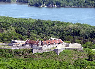
Fort Ticonderoga, formerly Fort Carillon, is a large 18th-century star fort built by the French at a narrows near the south end of Lake Champlain, in northern New York, in the United States. It was constructed by Canadian-born French military engineer Michel Chartier de Lotbinière, Marquis de Lotbinière between October 1755 and 1757, during the action in the "North American theater" of the Seven Years' War, often referred to in the US as the French and Indian War. The fort was of strategic importance during the 18th-century colonial conflicts between Great Britain and France, and again played an important role during the American Revolutionary War.

Roseau is the capital and largest city of Dominica, with a population of 14,725. It is a small and compact urban settlement, in the Saint George parish and surrounded by the Caribbean Sea, the Roseau River and Morne Bruce. Built on the site of the ancient Kalinago Indian village of Sairi, it is the oldest and most important urban settlement on the island of Dominica.

St. Simons Island is a barrier island and census-designated place (CDP) located on St. Simons Island in Glynn County, Georgia, United States. The names of the community and the island are interchangeable, known simply as "St. Simons Island" or "SSI", or locally as "The Island". St. Simons is part of the Brunswick, Georgia Metropolitan Statistical Area, and according to the 2010 census, the CDP had a population of 12,743.

Quarry Bank Mill in Styal, Cheshire, England, is one of the best preserved textile mills of the Industrial Revolution and is now a museum of the cotton industry. Built in 1784, the mill is recorded in the National Heritage List for England as a designated Grade II* listed building, and inspired the 2013 television series The Mill. It was established by Samuel Greg. The mill was notable for the innovative approach to labour relations, largely as a result of the work of Greg's wife, Hannah Lightbody.

Prospect Bluff Historic Sites is located in Franklin County, Florida, on the Apalachicola River, 6 miles (9.7 km) SW of Sumatra, Florida. The site contains the ruins of two forts – the earlier Negro Fort, built in 1814 by the British and destroyed in an attack from U.S. forces including a barrage of cannonballs from gunboats and Fort Gadsden, built in 1818 within the former walls of Negro Fort. The site has been known by several other names at various times, including Prospect Bluff, British post, Nicholls' Fort, Blount's Fort, Fort Blount, African Fort, and Fort Apalachicola.

Marie-Galante is one of the islands that form Guadeloupe, an overseas department of France. Marie-Galante has a land area of 170.5 km². It had 11,528 inhabitants at the start of 2013, with a population density of 67.6 people per km².

Saint Joseph is one of Dominica's 10 administrative parishes. It is bordered by St. Peter to the north, St. Andrew to the northeast, St. David to the east, and St. Paul to the south. It has an area of 120.1 km², and a population of 5,765.
The Battle of Vasai was fought between the Marathas and the Portuguese rulers of Vasai, a town lying near Mumbai (Bombay) in the present-day state of Maharashtra, India. The Marathas were led by Chimaji Appa, a brother of Peshwa Baji Rao I. Maratha victory in this war was a major achievement of Baji Rao I's reign.
Scotts Head is a village on the southwest coast of Dominica, in Saint Mark Parish. In 2001, its population was 721. Predominantly a fishing village, Scotts Head overlooks Soufrière Bay, which is protected as the Soufrière Scotts Head Marine Reserve. It is also a popular snorkeling and diving site for tourists.

Calibishie is a Village in Dominica. It is located on the northeast coast of the island, immediately to the east of the village of Hampstead. The Calibishie Coast Travel Area is thought by many to be the most scenic and unspoiled region of Dominica. The Calibishie Coast is one of the few areas in the world where you can travel from the seashore to rain forest in little more than a mile. Calibishie is home to Dominica's Batibou, Hampstead, Hodges, Point Baptiste, Turtle and Woodford Hill Beaches.
Mero is a small town in Saint Joseph Parish, Dominica. It is located in the west of the island, to the north of the mouth of the Layou River. To the north of Mero is Baroui and to the south of Mero is Saint Joseph.

Tomotley is a prehistoric and historic Native American site in Monroe County, Tennessee, in the southeastern United States. Occupied as early as the Archaic period, the Tomotley site had the most substantial periods of habitation during the Mississippian period, likely when the earthwork mounds were built and later during the mid to late eighteenth century as a refugee village of Cherokee from the Lower, Middle and Valley towns.

The Wormsloe Historic Site, informally known as Wormsloe Plantation, is a state historic site near Savannah, Georgia, in the southeastern United States. The site consists of 822 acres (3.33 km2) protecting part of what was once the Wormsloe Plantation, a large estate established by one of Georgia's colonial founders, Noble Jones. The site includes a picturesque 1.5 miles (2.4 km) oak avenue, the ruins of Jones' fortified house built of tabby, a museum, and a demonstration area interpreting colonial daily life.
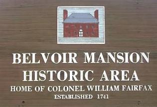
Belvoir was the historic plantation and estate of colonial Virginia's prominent William Fairfax family. It was situated on the west bank of the Potomac River in Fairfax County, Virginia, at the present site of Fort Belvoir. The main house — called Belvoir Manor or Belvoir Mansion — burned in 1783 and was completely destroyed during the War of 1812. The site has been listed on the National Register of Historic Places since 1973 as "Belvoir Mansion Ruins and the Fairfax Grave."

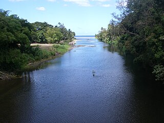
The Pagua River is one of the longest rivers on the Caribbean island of Dominica. It originates in the D'Leau Gommier area of the Central Forest Reserve, where it shares the same watershed as the Layou River. It flows northeastward, forming the western boundary of the Carib Territory. It empties into the Atlantic Ocean in Pagua Bay, on Dominica's east coast.

Fort Haldane is located near Port Maria in the parish of St Mary, Jamaica and was erected in 1759. It was named after General George Haldane, then Governor of Jamaica. The fort was constructed to protect the harbour of Port Maria from Spanish raids. It was also used as a garrison to keep the enslaved and working classes of St. Mary under control.

The 1804 Antigua–Charleston hurricane was the most severe hurricane in Georgia since 1752, causing over 500 deaths and at least $1.6 million (1804 USD) in damage throughout the Southeastern United States. Originating near Antigua on 3 September, it initially drifted west-northwestward, soon nearing Puerto Rico. Throughout its existence in the Caribbean Sea, the hurricane damaged, destroyed, and capsized numerous ships, and at Saint Kitts, it was considered to be the worst since 1772. By 4 September, the storm arrived at the Bahamas and turned northward before approaching the coast of northern Florida on 6 September. The hurricane eventually came ashore along the coastline of Georgia and South Carolina while producing mostly southeasterly winds. A severe gale was noted in New England later that month, on 11 and 12 September, although it was likely not the same system as that which had passed through the Caribbean and southeastern United States earlier that month.