Saint David Parish, Dominica

Last updated
Saint David
Carib Territory (Dominica).jpg
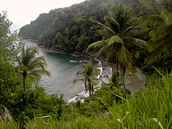
Carib Territory coast
Saint-David Dominica.png
Country Dominica
Capital Castle Bruce
Area
  Total131.5 km2 (50.8 sq mi)
Population
 (2011)
  Total6,043
  Density46/km2 (120/sq mi)
Time zone UTC-4
ISO 3166-2 DM-03

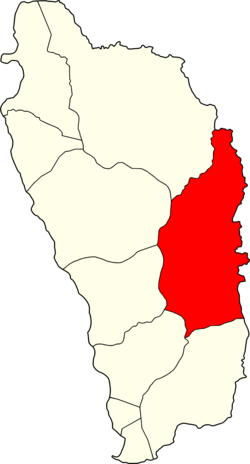
Saint David is one of Dominica's ten administrative parishes, located on the eastern side of the island. [1] It is bordered by St. Andrew to the north; St. Joseph, St. Paul and St. George to the west; and St. Patrick to the south. With that, it's bordered by five other parishes, more than any other one in Dominica. It has an area of 131.6 km2 (50.8 mi2), [2] and has a population of 6,789. [3]

Contents

Settlements

Its largest settlement is Castle Bruce, with a population of 1,653. [3] It includes the Indigenous community of the Kalinago Territory (formerly the Carib Territory) which has a population of about 3000 spread across 7 hamlets. Other villages include:

Areas of interest

The northern area of the parish is also home to the island's Carib Territory, in and around which 3,000 pure, indigenous Caribs live.

Related Research Articles

The first written records in the history of Dominica began in November 1493, when Christopher Columbus spotted the island. Prior to European contact, Dominica was inhabited by the Arawak. Dominica was a French colony from 1715 until the end of the Seven Years' War in 1763, and then became a British colony from 1763 to 1978. It became an independent nation in 1978.

This is a demography of the population of Dominica including population density, ethnicity, religious affiliations and other aspects of the population.

<span class="mw-page-title-main">Kalinago</span> Group of people who live in Venezuela and the Lesser Antilles

The Kalinago, formerly known as Island Caribs or simply Caribs, are an Indigenous people of the Lesser Antilles in the Caribbean. They may have been related to the Mainland Caribs (Kalina) of South America, but they spoke an unrelated language known as Island Carib. They also spoke a pidgin language associated with the Mainland Caribs.

The Carib Expulsion from Martinique was the French-led ethnic cleansing that removed most of the Kalinago population in 1660 from the island of Martinique. This followed the French invasion in 1635 and its conquest of the Caribbean island that made it part of the French West Indies.

<span class="mw-page-title-main">Saint Andrew Parish, Dominica</span> Parish in Dominica

Saint Andrew is one of Dominica's 10 administrative parishes. It is bordered by St. John and St. Peter, St. Joseph, and St. David.

<span class="mw-page-title-main">Saint John Parish, Dominica</span> Parish in Dominica

Saint John is one of Dominica's 10 administrative parishes. It is bordered by St. Andrew to the east, and St. Peter and the Espagnole River to the south. It has an area of 59 km2 (22.78 mi2).

<span class="mw-page-title-main">Saint Luke Parish, Dominica</span> Parish in Dominica

Saint Luke is one of Dominica's 10 administrative parishes. It is bordered by St. George to the north, St. Mark to the south, and St. Patrick to the east.

<span class="mw-page-title-main">Portsmouth, Dominica</span> Town in Saint John Parish, Dominica

Portsmouth is the second largest town in Dominica, with 3,630 inhabitants. It is located on the shore of a natural Harbor, Prince Rupert Bay, in Saint John Parish on the north-west coast of Dominica. The area was called Ouyouhao by the Kalinago and Grand Anse by the French. The Indian River is Portsmouth’s southern border and Cabrits National Park is located on a peninsula to the north of town.

<span class="mw-page-title-main">Vieille Case</span> Village in Saint Andrew Parish, Dominica

Vieille Case, sometimes spelled as Vielle-Case, is a village on the north coast of Dominica. The Commonwealth of Dominica in the West Indies was first inhabited by the Kalinago people who were referred to as Caribs by the Europeans. Itassi is the Kalinago name for the area in Dominica which is now known as Vieille Case.

Canefield is a town located on the west coast of Dominica, north of Roseau and south of Massacre, overlooking Pringle's Bay. The largest settlement in St. Paul Parish, it has a population of 2,803. It is home to an industrial estate with Harris Paints Dominica Ltd., a branch of the Jehovah's Witnesses, the Old Mill Cultural Center and Museum as well as the island's second airport. Neighboring locales include Cochrane, Checkhall, Massacre and Fond Colé.

<span class="mw-page-title-main">Calibishie</span> Place in Saint Andrew Parish, Dominica

Calibishie is a village in Dominica, located on the north-east coast of the island, immediately to the east of the village of Hampstead. The Calibishie Coast Travel Area is thought by many to be the most scenic and unspoiled region of Dominica. The Calibishie coast is one of the few areas in the world where the distance from the seashore to rain forest is little more than a mile. Calibishie is home to Dominica's Batibou, Hampstead, Hodges, Point Baptiste, Turtle and Woodford Hill Beaches.

<span class="mw-page-title-main">Massacre, Dominica</span>

Massacre is a town in Saint Paul Parish, Dominica, with about 1,200 inhabitants. It is located on the central west coast of the island, to the north of the capital, Roseau, on the Massacre River.

<span class="mw-page-title-main">Kalinago genocide of 1626</span> Massacre of 2,000 Kalinago in 1626

The Kalinago genocide was the genocidal massacre of an estimated 2,000 Kalinago people by English and French settlers on the island of Saint Kitts in 1626.

Sir Thomas Warner was a captain in the guards of James I of England who became an explorer in the Caribbean. In 1620 he served at the brief-lived English settlement of Oyapoc in present-day Guyana of South America, which was abandoned the same year. The Dutch controlled most of the territory. Warner is noted for settling on Saint Kitts and establishing it in 1624 as the first English colony in the Caribbean.

<span class="mw-page-title-main">Dominica</span> Country in the Caribbean

Dominica, officially the Commonwealth of Dominica, is an island country in the Caribbean. It is part of the Windward Islands chain in the Lesser Antilles archipelago in the Caribbean Sea. The capital, Roseau, is located on the western side of the island. Dominica's closest neighbours are two constituent territories of the European Union, the overseas departments of France, Guadeloupe to the northwest and Martinique to the south-southeast. Dominica comprises a land area of 750 km2 (290 sq mi), and the highest point is Morne Diablotins, at 1,447 m (4,747 ft) in elevation. The population was 71,293 at the 2011 census.

Penville or Pennville is a village in Dominica's Saint Andrew Parish. The community is situated just north of Vieille Case, and has a population of 524.

<span class="mw-page-title-main">Outline of Dominica</span> Overview of and topical guide to Dominica

The following outline is provided as an overview of and topical guide to Dominica:

<span class="mw-page-title-main">Roseau Cathedral</span>

The Cathedral of Our Lady of Fair Haven of Roseau, originally known in French as Église de Notre-Dame du Bon Port du Mouillage de Roseau, is a Roman Catholic cathedral in Roseau, the capital city of Dominica in the Caribbean. The church is the see of the Diocese of Dominica, suffragan diocese of the Archdiocese of Castries, Saint Lucia.

<span class="mw-page-title-main">Kalinago Territory</span> District of Dominica

The Kalinago Territory, previously known as the Carib Reserve or Carib Territory (outdated/derogatory), is a 3,700-acre (15 km2) district in the Caribbean island country of Dominica. It was established for the Indigenous Kalinago people who inhabited the region prior to European colonization and settlement.

<span class="mw-page-title-main">Chief of the Kalinago Territory</span>

The Chief of the Kalinago Territory presides over the Kalinago Council, the local government of the Kalinago Territory. The position is the equivalent of a village council chairperson elsewhere in Dominica. Beginning in the late 20th century, Kalinago Chiefs have also acted as a representative of the Kalinago Territory to other indigenous populations in the Caribbean region, and have worked with organizations including the Caribbean Organization of Indigenous Peoples and the United Nations Working Group on Indigenous Populations.

References

  1. "The World Factbook". CIA. Retrieved 2020-03-27.
  2. Figures provided by the Lands and Surveys Division of the Ministry of Agriculture, Cork Street, Roseau, Dominica.
  3. 1 2 Commonwealth of Dominica, Population and Housing Census – 2001. Roseau, Dominica: Central Statistical Office, Ministry of Finance and Planning, Kennedy Avenue, 2001.