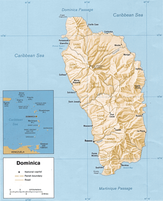
Dominica is an island in the Caribbean Sea, located about halfway between the French islands of Guadeloupe and Martinique. Its coordinates are 15 25 N, 61 20 W. It is known as "The Nature Island of the Caribbean" due to its spectacular, lush, and varied flora and fauna, which is protected by an extensive natural park system. It is the fourth largest island in the Eastern Caribbean with a population of people mainly of African descent.

Roseau is the capital and largest city of Dominica, with a population of 14,725 as of 2011. It is a small and compact urban settlement, in the Saint George parish and surrounded by the Caribbean Sea, the Roseau River and Morne Bruce. Built on the site of the ancient Island Carib village of Sairi, it is the oldest and most important urban settlement on the island of Dominica.

Dominica is divided into ten parishes. The largest parish by population in Dominica is Saint George which contains the capital city Roseau and has a total population of 21,241. The smallest parish by population is Saint Peter with 1,430 residents. The largest parish by land area is Saint Andrew which spans 179.9 km2 (69.5 sq mi), while Saint Luke is the smallest at 10.8 km2 (4.2 sq mi).
Saint David is one of Dominica's ten administrative parishes, located on the eastern side of the island. It is bordered by St. Andrew to the north; St. Joseph, St. Paul and St. George to the west; and St. Patrick to the south. With that, it's bordered by five other parishes, more than any other one in Dominica. It has an area of 131.6 km2 (50.8 mi2), and has a population of 6,789.

Saint George is one of Dominica's 10 administrative parishes. It is bordered by Saint Paul and part of the Boeri River, Saint David and Saint Patrick, Saint Luke.

Saint John is one of Dominica's 10 administrative parishes. It is bordered by St. Andrew to the east, and St. Peter and the Espagnole River to the south. It has an area of 59 km2 (22.78 mi2).

Saint Luke is one of Dominica's 10 administrative parishes. It is bordered by St. George to the north, St. Mark to the south, and St. Patrick to the east.

Saint Mark is one of Dominica's ten administrative parishes. It is bordered by St. Luke and St. Patrick. With an area of 9.9 km² (3.8 mi²), it is the second smallest in the island. It had a population of 1,834 people at the Population Census of 2011.
Portsmouth is the second largest town in Dominica, with 3,630 inhabitants. It is located on the shore of a natural Harbor, Prince Rupert Bay, in Saint John Parish on the north-west coast of Dominica. The area was called Ouyouhao by the Kalinago and Grand Anse by the French. The Indian River is Portsmouth’s southern border and Cabrits National Park is located on a peninsula to the north of town.

Wesley is a village in Saint Andrew Parish in north-eastern Dominica. It situated between the old estates of Eden and Londonderry and 1 1/2 miles southeast of Woodford Hill. Like many other villages along the east coast, Wesley developed after Emancipation on hilly land along the boundary between the two estates as labourers sought to establish independent holdings for themselves away from the plantations where they had formerly lived and worked.

Colihaut is a coastal village in northern Dominica within Saint Peter Parish midway between the towns of Roseau and Portsmouth. It has a population of 773 people.

Marigot is the largest settlement of Saint Andrew Parish in northeastern Dominica. The village has a population of 2,676 people, and is home to a Fisheries Complex as well as the island's main airport.
Grand Bay, known officially as Berekua or Berricoa, is a village in the south of Dominica. It has a population of 2,288 as of 2010, and is the largest settlement in St. Patrick Parish.

Vieille Case, sometimes spelled as Vielle-Case, is a village on the north coast of Dominica. The Commonwealth of Dominica in the West Indies was first inhabited by the Kalinago people who were referred to as Caribs by the Europeans. Itassi is the Kalinago name for the area in Dominica which is now known as Vieille Case.

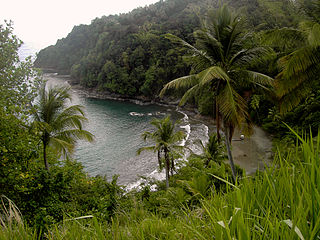
Calibishie is a village in Dominica, located on the north-east coast of the island, immediately to the east of the village of Hampstead. The Calibishie Coast Travel Area is thought by many to be the most scenic and unspoiled region of Dominica. The Calibishie coast is one of the few areas in the world where the distance from the seashore to rain forest is little more than a mile. Calibishie is home to Dominica's Batibou, Hampstead, Hodges, Point Baptiste, Turtle and Woodford Hill Beaches.

Saint Lucia, an island nation in the Caribbean islands, has a relatively large tourism industry. Due to the relatively small land area of the country, most of the governmental promotion is performed by the state-operated Saint Lucia Tourism Authority, led by Executive Chairperson Agnes.

Dominica, officially the Commonwealth of Dominica, is an island country in the Caribbean. It is part of the Windward Islands chain in the Lesser Antilles archipelago in the Caribbean Sea. The capital, Roseau, is located on the western side of the island. Dominica's closest neighbours are two constituent territories of the European Union, the overseas departments of France, Guadeloupe to the northwest and Martinique to the south-southeast. Dominica comprises a land area of 750 km2 (290 sq mi), and the highest point is Morne Diablotins, at 1,447 m (4,747 ft) in elevation. The population was 71,293 at the 2011 census.
Penville or Pennville is a village in Dominica's Saint Andrew Parish. The community is situated just north of Vieille Case, and has a population of 524.
Belles is a small village in the Caribbean island nation of Dominica. It is located at 15°27′12.7″N61°19′11.4″W and is a part of the country's St. Joseph administrative division. Its population is 500. Belles is a historical site for a few reasons. It is a major part of the highway system to the northern part of the island. The roads were blocked many years ago by Rastafarians who were not happy with the government. Many of them escaped to Jaco Flats and used it for refuge. This is a site that was used by the Maroons hundreds of years ago. As of 2016, the Esprit and Benjamin families own and control a majority of the private land.


