
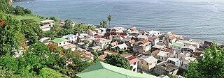
Roseau is the capital and largest city of Dominica, with a population of 14,725 as of 2011. It is a small and compact urban settlement, in the Saint George parish and surrounded by the Caribbean Sea, the Roseau River and Morne Bruce. Built on the site of the ancient Island Carib village of Sairi, it is the oldest and most important urban settlement on the island of Dominica.

The Kalinago, formerly known as Island Caribs or simply Caribs, are an Indigenous people of the Lesser Antilles in the Caribbean. They may have been related to the Mainland Caribs (Kalina) of South America, but they spoke an unrelated language known as Island Carib. They also spoke a pidgin language associated with the Mainland Caribs.

Torquay is a seaside resort in Victoria, Australia, which faces Bass Strait, 21 km south of Geelong and is the gateway to the Great Ocean Road. It is bordered on the west by Spring Creek and its coastal features include Point Danger and Zeally Bay. At the 2021 census, Torquay had a population of 18,534.
The culture of Dominica is formed by the inhabitants of the Commonwealth of Dominica. Dominica is home to a wide range of people. Although it was historically occupied by several native tribes, it was the Taíno and Island Caribs (Kalinago) tribes that remained by the time European settlers reached the island. "Massacre" is a name of a river dedicated to the murders of the native villagers by both French and British settlers, because the river "ran red with blood for days." Each claimed the island and imported slaves from Africa. The remaining Caribs now live on a 3,700-acre (15 km2) Carib Territory on the east coast of the island. They elect their own chief.

Saint Andrew is one of Dominica's 10 administrative parishes. It is bordered by St. John and St. Peter, St. Joseph, and St. David.
Saint David is one of Dominica's ten administrative parishes, located on the eastern side of the island. It is bordered by St. Andrew to the north; St. Joseph, St. Paul and St. George to the west; and St. Patrick to the south. With that, it’s bordered by five other parishes, more than any other one in Dominica. It has an area of 131.6 km² (50.8 mi²), and has a population of 6,789.

Portsmouth is the second largest town in Dominica, with 3,630 inhabitants. It is located on the shore of a natural Harbor, Prince Rupert Bay, in Saint John Parish on the north-west coast of Dominica. The area was called Ouyouhao by the Kalinago and Grand Anse by the French. The Indian River is Portsmouth’s southern border and Cabrits National Park is located on a peninsula to the north of town.

Colihaut is a coastal village in northern Dominica within Saint Peter Parish midway between the towns of Roseau and Portsmouth. It has a population of 773 people.
Dublanc is a village in Saint Peter parish on the west coast of Dominica between the town of Portsmouth and the village of Bioche. It sits on a low hillside at an elevation of 27. As of 2001 it had a population of 423.
Calibishie is a village in Dominica, located on the north-east coast of the island, immediately to the east of the village of Hampstead. The Calibishie Coast Travel Area is thought by many to be the most scenic and unspoiled region of Dominica. The Calibishie coast is one of the few areas in the world where the distance from the seashore to rain forest is little more than a mile. Calibishie is home to Dominica's Batibou, Hampstead, Hodges, Point Baptiste, Turtle and Woodford Hill Beaches.

Massacre is a town in Saint Paul Parish, Dominica, with about 1,200 inhabitants. It is located on the central west coast of the island, to the north of the capital, Roseau, on the Massacre River.

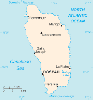
Dominica, officially the Commonwealth of Dominica, is an island country in the Caribbean. It is part of the Windward Islands chain in the Lesser Antilles archipelago in the Caribbean Sea. The capital, Roseau, is located on the western side of the island. Dominica's closest neighbours are two constituent territories of the European Union, the overseas departments of France, Guadeloupe to the northwest and Martinique to the south-southeast. Dominica comprises a land area of 750 km2 (290 sq mi), and the highest point is Morne Diablotins, at 1,447 m (4,747 ft) in elevation. The population was 71,293 at the 2011 census.
Bense is a village on the northern coast of Dominica which, together with the neighbouring village of Hampstead, Dominica, has a population of around 780 people. It comprises three hamlets, Bense, Anse de Mai, and Anse Soldat, which are together grouped under one village council. The village is served along with its neighbours, Hampstead and Calibishie, by member of parliament and Minister of Information, Community Development, and Gender Affairs, the Honourable Matthew Walter. Another notable Bense native is Minister of Health and Social Security the Honourable John Fabien.
Penville or Pennville is a village in Dominica's Saint Andrew Parish. The community is situated just north of Vieille Case, and has a population of 524.
Thibaud is a village on the northern coast of Dominica, part of Saint Andrew Parish. It has a population of approximately 500. Located near Vieille Case, Thibaud's main industries are fishing and farming.
Tourism in Dominica consists mostly of hiking in the rain forest and visiting cruise ships.

The Kalinago Territory, previously known as the Carib Reserve or Carib Territory (outdated/derogatory), is a 3,700-acre (15 km2) district in the Caribbean island country of Dominica. It was established for the Indigenous Kalinago people who inhabited the region prior to European colonization and settlement.

The Chief of the Kalinago Territory presides over the Kalinago Council, the local government of the Kalinago Territory. The position is the equivalent of a village council chairperson elsewhere in Dominica. Beginning in the late 20th century, Kalinago Chiefs have also acted as a representative of the Kalinago Territory to other indigenous populations in the Caribbean region, and have worked with organizations including the Caribbean Organization of Indigenous Peoples and the United Nations Working Group on Indigenous Populations.

