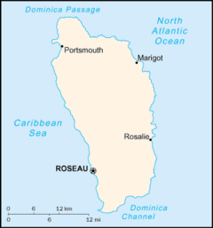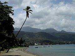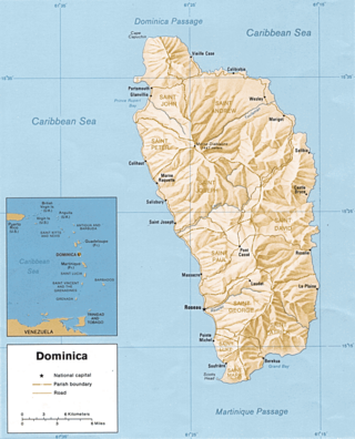
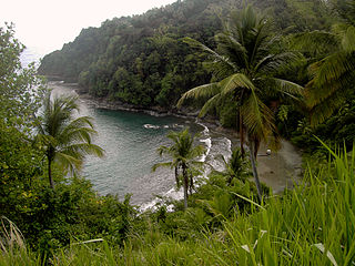
Dominica is an island in the Caribbean Sea, located about halfway between the French islands of Guadeloupe and Martinique. Its coordinates are 15 25 N, 61 20 W. It is known as "The Nature Island of the Caribbean" due to its spectacular, lush, and varied flora and fauna, which is protected by an extensive natural park system. It is the fourth largest island in the Eastern Caribbean with a population of people mainly of African descent.

Roseau is the capital and largest city of Dominica, with a population of 14,725 as of 2011. It is a small and compact urban settlement, in the Saint George parish and surrounded by the Caribbean Sea, the Roseau River and Morne Bruce. Built on the site of the ancient Island Carib village of Sairi, it is the oldest and most important urban settlement on the island of Dominica.

Artibonite is one of the ten departments of Haiti located in central Haiti. With an area of 4,887 km2 it is Haiti's largest department. As of 2015, its estimated population was 1,727,524. The region is the country's main rice-growing area. The main cities are Gonaïves and Saint-Marc. In February 2004 an insurgency tried unsuccessfully to declare Artibonite's independence.

Morne Diablotin is the highest mountain in Dominica, an island-nation in the Caribbean Lesser Antilles. It is the second highest mountain in the Lesser Antilles, after La Grande Soufrière in Guadeloupe. Morne Diablotin is located in the northern interior of the island, about 24 kilometres (15 mi) north of Dominica's capital Roseau and about 10 kilometres (6.2 mi) southeast of Portsmouth, the island's second-largest town. It is located within Morne Diablotin National Park.

Marie-Galante is one of the dependencies of Guadeloupe, an overseas department of France. Marie-Galante has a land area of 158.1 km2. It had 11,528 inhabitants at the start of 2013, but by the start of 2018 the total was officially estimated to be 10,655, with a population density of 62.5/km2 (162/sq mi).
Saint David is one of Dominica's ten administrative parishes, located on the eastern side of the island. It is bordered by St. Andrew to the north; St. Joseph, St. Paul and St. George to the west; and St. Patrick to the south. With that, it's bordered by five other parishes, more than any other one in Dominica. It has an area of 131.6 km2 (50.8 mi2), and has a population of 6,789.

Saint John is one of Dominica's 10 administrative parishes. It is bordered by St. Andrew to the east, and St. Peter and the Espagnole River to the south. It has an area of 59 km2 (22.78 mi2).
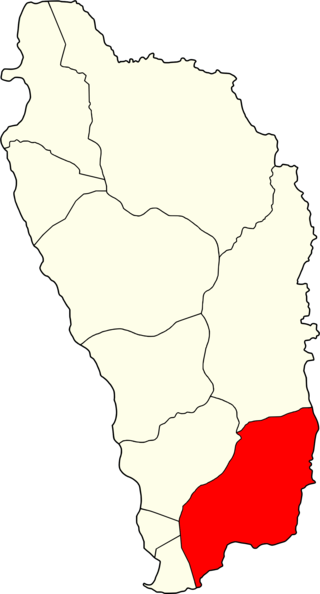
Saint Patrick is one of Dominica's 10 administrative parishes. It is bordered by St. George, St. Luke and St. Mark to the west, and St. David to the north. It has an area of 84.4 km² (32.59 mi²), and has a population of 8,383.

Terre-de-Bas Island is an island in the Îles des Saintes archipelago, in the Lesser Antilles.

The Metropolitan Archdiocese of Castries is an archdiocese of the Latin Church of the Catholic Church in the Caribbean. The archdiocese consists of the entirety of the former British dependency of Saint Lucia and is a metropolitan see, the suffragans of the Castries Province being the Dioceses of Roseau, Saint George's in Grenada, St. John's-Basseterre and Kingstown. The archdiocese is a member of the Antilles Episcopal Conference.

Mahaut is a village on the west coast of Dominica. It has a population of 2,399, which makes it the second largest commune in the parish of Saint Paul and was home to Dominica Colgate-Palmolive until the factory was closed in 2015 after Tropical Storm Erika.
Grand Bay, also known as Berekua or Berricoa, is a village in the south of Dominica. It has a population of 2,288 as of 2010, and is the largest settlement in St. Patrick Parish.

Articles related to the French overseas department of Guadeloupe include:
Petit Soufrière is a small village on the east coast of Dominica, upland from Petite Soufrière Bay in Saint David Parish. Located on the steep, rugged slopes of Morne Aux Delices at the end of the main road south from Castle Bruce, it is one of the most isolated villages in Dominica. The village immediately to its north is Saint Sauveur; to its south, though connected only by a hiking trail, is Rosalie.

Morne Rachette or Morne Raquette is a village on the west coast of Dominica, in the northwest corner of Saint Joseph Parish. It is located on the slopes of Morne Jalousie, above Coulibistrie to its immediate north and Batalie Bay. The village of Salisbury is south of Morne Rachette.

Îlet à Cabrit, officially French: îlet à Cabrit des Saintes, is an island in the Îles des Saintes, Guadeloupe, the Lesser Antilles. It belongs to the commune of Terre-de-Haut.

The communal section is the smallest administrative division in Haiti. The 144 communes are further divided into 571 communal sections.