List of cities in Panama

Last updated

A map of Panama. Pm-map.png
A map of Panama.
Panama City, Panama's capital city. Via Espana, ciudad de Panama. .jpg
Panama City, Panama's capital city.
Colon City, capital of the Colon province. Ciudad de Colon, Panama.jpg
Colón City, capital of the Colón province.
David, capital of the Chiriqui province. David-Panama.jpg
David, capital of the Chiriquí province.
La Chorrera, capital of the Panama Oeste province. Distrito de La Chorrera.jpg
La Chorrera, capital of the Panamá Oeste province.
Santiago, capital of the Veraguas province. Catedral santiago veraguas.jpg
Santiago, capital of the Veraguas province.

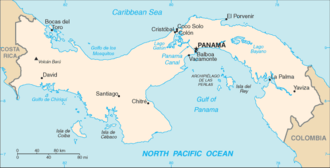
This is a list of cities in Panama .

Largest cities

Changuinola, the most populated city of Bocas del Toro. Sediments (4078762256).jpg
Changuinola, the most populated city of Bocas del Toro.

These are the largest 20 Panamanian cities and towns, listed in descending order. All figures are estimates for the year 2016. [1] The last census took place in 2010. Provincial capitals are shown in bold.

Contents

CityPopulation Province
1 Panamá 1,756,781 Panamá
2 Colón 241,817 Colón
3 David 193,350 Chiriquí
4 La Chorrera 190,093 Panamá Oeste
5 Santiago 98,431 Veraguas
6 Changuinola 98,334 Bocas del Toro
7 Penonomé 92,766 Coclé
8 Bugaba 82,930 Chiriquí
9 Puerto Armuelles 58,093 Chiriquí
10 Antón 56,485 Coclé
11 Chepo 56,396 Panamá
12 Chitré 55,988 Herrera
13 Aguadulce 50,478 Coclé
14 Capira 45,255 Panamá Oeste
15 Chame 29,746 Panamá Oeste
16 Soná 29,586 Veraguas
17 Almirante 29,539 Bocas del Toro
18 La Pintada 29,535 Coclé
19 Las Tablas 29,297 Los Santos
20 La Villa de Los Santos 27,300 Los Santos

Alphabetical list

See also

Related Research Articles

Huarijio is a Uto-Aztecan language of the states of Chihuahua and Sonora in northwestern Mexico. It is spoken by around 2,100 Huarijio people, most of whom are monolinguals.

<span class="mw-page-title-main">Municipalities of Venezuela</span>

Municipalities of Venezuela are subdivisions of the States of Venezuela. There are 335 municipalities dividing the 23 states and the Capital District.

Tlatlaya is one of 125 municipalities of the State of Mexico in Mexico. The municipal seat is the town of Tlatlaya which is the eleventh largest town in the municipality. The word “Tlatlaya” means when the hearth is black and red.

Santo Tomás de los Plátanos also known as Nuevo Santo Tomás de los Plátanos is a town and municipal seat of the municipality of Santo Tomás, located in the center-west of Mexico State, in Mexico. It is approximately 185 km from Mexico City, and 107 km from Toluca.

Otzoloapan Municipality is a municipality located at the southeast of the State of Mexico. The name is from the Náhuatl 'Oceloapan' which means "river of lynxes". It is located in the southwest part of the state bordering the state of Michoacán.

<span class="mw-page-title-main">Tejupilco Municipality</span> Municipality in State of Mexico, Mexico

Tejupilco is a municipality in the State of Mexico, Mexico, located approximately 100 kilometres (62 mi) southwest of the state capital Toluca, along Federal Highway 134. Its municipal seat is Tejupilco de Hidalgo. The municipality has a total area of about 1,327 km2 (512 sq mi), with a contrasting topography ranging from deep ravines and canyons to high ridges; the highest elevation within the municipality reaches some 1,117 metres (3,660 ft) asl. The 2005 census recorded a population of 62,547 inhabitants.

Luvianos is a small town and municipality located in the southwest of the State of Mexico. It gained municipal status in 2000. People can access Luvianos by driving Federal Road 134 south from Toluca, and then take a detour about 25 minutes north of Tejupilco. The name is derived from a hacienda what was established during colonial times.

<span class="mw-page-title-main">Districts of Panama</span> Sub-divisions of provinces and some of the comarcas in Panama

The provinces of Panama and some of the comarcas are divided into districts (distrito). The district are further divided into corregimientos of Panama

<span class="mw-page-title-main">Santiago Papasquiaro Municipality</span> Municipality in Durango, Mexico

Santiago Papasquiaro is one of the 39 municipalities of Durango, in north-western Mexico. The municipal seat lies at Santiago Papasquiaro. The municipality covers an area of 7,238.4 km². Santiago Papasquiaro municipality is at an average height of 1,730 m (5,675 ft) over the sea level. The municipality lies east of Sierra Madre Occidental Mountain Range. It neighbors with other municipalities: Canelas and Tepehuanes municipalities at the north; San Dimas and Otáez, south; Nuevo Ideal to the east, Tamazula to the west and El Oro located northeast.

<span class="mw-page-title-main">Guararé District</span> District in Los Santos Province, Panama

Guararé District is a district (distrito) of Los Santos Province in Panama. The population according to the 2000 census was 9,485. The district covers a total area of 216 km². The capital lies at the city of Guararé.

<span class="mw-page-title-main">Macaracas District</span> District in Los Santos Province, Panama

Macaracas District is a district (distrito) of Los Santos Province in Panama. The population according to the 2000 census was 9,137. The district covers a total area of 504 km². The capital lies at the city of Macaracas.

Santo Tomás is one of 125 municipalities in the State of Mexico. The municipal seat is the town of Santo Tomás de los Plátanos located in the center-west of Mexico State, in Mexico. It is approximately 185 km from Mexico City, and 107 km from Toluca.

References

  1. "ESTIMACIÓN DE LA POBLACIÓN TOTAL EN LA REPÚBLICA, POR SEXO, SEGÚN PROVINCIA, COMARCA INDÍGENA Y DISTRITO: AL 1 DE JULIO DE 2016" (PDF). www.contraloria.gob.pa/INEC.

Commons-logo.svg Media related to Cities in Panama at Wikimedia Commons