Los Boquerones | |
|---|---|
 Los Boquerones | |
| Coordinates: 8°4′48″N80°51′0″W / 8.08000°N 80.85000°W | |
| Country | Panama |
| Province | Veraguas |
| Population (2008) | |
| • Total | 1 157 |
Los Boquerones is a town in the Veraguas province of Panama.
Los Boquerones | |
|---|---|
| Los Boquerones | |
| Coordinates: 8°4′48″N80°51′0″W / 8.08000°N 80.85000°W | |
| Country | Panama |
| Province | Veraguas |
| Population (2008) | |
| • Total | 1 157 |
Los Boquerones is a town in the Veraguas province of Panama.
| Authority control databases: National |
|---|

Central America is a subregion of the Americas. Its political boundaries are defined as bordering Mexico to the north, Colombia to the south, the Caribbean Sea to the east, and the Pacific Ocean to the west. Central America usually consists of seven countries: Belize, Costa Rica, El Salvador, Guatemala, Honduras, Nicaragua, and Panama. Within Central America is the Mesoamerican biodiversity hotspot, which extends from northern Guatemala to central Panama. Due to the presence of several active geologic faults and the Central America Volcanic Arc, there is a high amount of seismic activity in the region, such as volcanic eruptions and earthquakes, which has resulted in death, injury, and property damage.

Panama, officially the Republic of Panama, is a transcontinental country in Central America, spanning the southern tip of North America into the northern part of South America. It is bordered by Costa Rica to the west, Colombia to the southeast, the Caribbean Sea to the north, and the Pacific Ocean to the south. Its capital and largest city is Panama City, whose metropolitan area is home to nearly half the country's over 4 million inhabitants.

The Panama Canal is an artificial 82 km (51 mi) waterway in Panama that connects the Atlantic Ocean with the Pacific Ocean, cutting across the Isthmus of Panama, and is a conduit for maritime trade. Canal locks at each end lift ships up to Gatun Lake, an artificial freshwater lake 26 meters (85 ft) above sea level, created by damming up the Chagres River and Lake Alajuela to reduce the amount of excavation work required for the canal, and then lower the ships at the other end. An average of 200,000,000 L (52,000,000 US gal) of fresh water are used in a single passing of a ship.
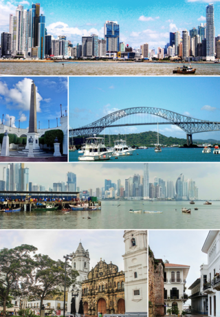
Panama City, also known as Panama, is the capital and largest city of Panama. It has a total population of 1,938,000, with over 1,500,000 in its urban area. The city is located at the Pacific entrance of the Panama Canal, in the province of Panama. The city is the political and administrative center of the country, as well as a hub for banking and commerce.

Panama City is a city in and the county seat of Bay County, Florida, United States. Located along U.S. Highway 98 (US 98), it is the largest city between Tallahassee and Pensacola. It is also the most populated city of the Panama City–Lynn Haven, Florida metropolitan statistical area. Panama City was severely damaged when Hurricane Michael made landfall as a Category 5 hurricane on October 10, 2018. As of the 2020 census, the population was 32,939, down from the figure of 36,484 at the 2010 census.

Panama City Beach is a resort town in Bay County, Florida, United States, on the Gulf of Mexico coast. It had a population of 12,018 in 2010. The city is often referred to under the umbrella term of "Panama City". Panama City Beach's slogan is "The World's Most Beautiful Beaches" due to the unique, sugar-white sandy beaches of northwest Florida.

Panama is a village in Montgomery and Bond counties, Illinois, United States. The population was 337 at the 2020 census.

The Panama national football team represents Panama in men's international football and is governed by the Panamanian Football Federation. The team represents all three FIFA, CONCACAF and the regional UNCAF.
Gonda district is one of the districts of Uttar Pradesh, India. The city of Gonda is the district headquarters, and also the administrative centre for the Devipatan Division. The total area of Gonda district is 4,003 km2 (1,546 sq mi).
Caimitillo is a town and corregimiento in the Panamá Province of Panama.
Guabito is a corregimiento and town in the Changuinola District of the Bocas del Toro Province of Panama. It is a small town located directly across the Rio Sixaola from Sixaola, Costa Rica. An elevated former railroad grade and bridge connects Guabito to Sixaola. This border crossing is popular with tourists going between Costa Rica and Bocas del Toro, though few tourists stop in Guabito longer than necessary to clear Panamanian customs.
Los Pollos is a town in the Coclé province of Panama.
Nuevo Arraiján is a town in Arraiján District in the Panamá Oeste Province of Panama.
Paso Blanco is a town in the Panamá province of Panama.
Potrero Grande is a town in the Panamá province of Panama.
San Vicente de Bique is a town in Arraiján District in the Panamá Oeste Province of Panama.

Ustupo is a town in the Kuna Yala province of Panama. The town comprises several small, bridge-linked islands around 600 metres (1,969 ft) off the coast.
Panama, formerly named Rio Bravo after the Spanish name for the Kern River, Rio Bravo de San Felipe, is an unincorporated community in Kern County, California. It is located 8 miles (13 km) south-southwest of Bakersfield, at an elevation of 351 feet (107 m) in the San Joaquin Valley.
Rio Bravo is a former settlement in Kern County, California. It was located on the railroad 2 miles (3.2 km) north of Panama.

The Panama Papers are 11.5 million leaked documents that were published beginning on April 3, 2016. The papers detail financial and attorney–client information for more than 214,488 offshore entities. The documents, some dating back to the 1970s, were created by, and taken from, former Panamanian offshore law firm and corporate service provider Mossack Fonseca, and compiled with similar leaks into a searchable database.