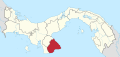
Los Santos is a province in Panama, reaching from the La Villa river in the North to the Pacific Ocean in the south and east. It is part of the Azuero Peninsula, bounded by the province of Herrera to the north and northeast, and by Mariato District of Veraguas Province to the West. The City of Las Tablas is the capital and most populous city. There are seven administrative districts under the jurisdiction of Los Santos Province. Los Santos's area is 3,809.4 km ², and its population is 98,466 inhabitants in 2023.
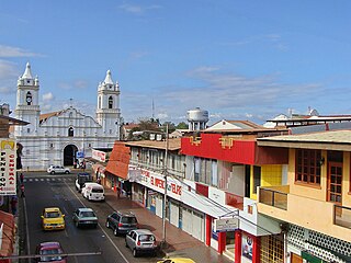
Chitré is a city and corregimiento, the capital of the Panamanian province of Herrera. with a population of 9,092 as of 2010, and a metropolitan area population of 80,000 inhabitants. It is also the seat of Chitré District. Chitré is located about 7 km inland from the Gulf of Parita on the Azuero Peninsula. The name Chitré comes from the native tribe Chitra. In the city, there is a district, also called Chitré, which is subdivided into five corregimientos. The corregimientos are San Juan Bautista, Llano Bonito, Monagrillo, La Arena and Chitré.
Agua Buena is a corregimiento in Los Santos District, Los Santos Province, Panama with a population of 1,117 as of 2010. It was created by Law 58 of July 29, 1998, owing to the Declaration of Unconstitutionality of Law 1 of 1982. Its population as of 2000 was 1,117.
La Espigadilla is a corregimiento in Los Santos District, Los Santos Province, Panama with a population of 1,675 as of 2010. Its population as of 1990 was 1,423; its population as of 2000 was 1,580.
La Tiza is a town and corregimiento in Las Tablas District, Los Santos Province, Panama with a population of 1,702 as of 2010. Its population as of 1990 was 1,167; its population as of 2000 was 1,662.
Llano Largo is a corregimiento in Los Santos District, Los Santos Province, Panama with a population of 2,265 as of 2010. Its population as of 1990 was 1,715; its population as of 2000 was 2,003.
La Enea is a corregimiento in Guararé District, Los Santos Province, Panama with a population of 1,186 as of 2010. Its population as of 1990 was 871; its population as of 2000 was 1,128.
La Pasera is a corregimiento in Guararé District, Los Santos Province, Panama with a population of 897 as of 2010. Its population as of 1990 was 1,007; its population as of 2000 was 780.
Bajo Corral is a corregimiento in Las Tablas District, Los Santos Province, Panama with a population of 483 as of 2010. Its population as of 1990 was 601; its population as of 2000 was 546.
La Laja is a corregimiento in Las Tablas District, Los Santos Province, Panama with a population of 547 as of 2010. Its population as of 1990 was 553; its population as of 2000 was 583.
La Miel is a corregimiento in Las Tablas District, Los Santos Province, Panama with a population of 290 as of 2010. Its population as of 1990 was 318; its population as of 2000 was 312.
La Palma is a corregimiento in Las Tablas District, Los Santos Province, Panama with a population of 1,247 as of 2010. Its population as of 1990 was 1,271; its population as of 2000 was 1,280.
La Colorada is a corregimiento in Los Santos District, Los Santos Province, Panama with a population of 1,030 as of 2010. Its population as of 1990 was 987; its population as of 2000 was 1,010.
Las Cruces is a corregimiento in Los Santos District, Los Santos Province, Panama with a population of 1,201 as of 2010. Its population as of 1990 was 1,118; its population as of 2000 was 1,198.
Las Guabas is a corregimiento in Los Santos District, Los Santos Province, Panama with a population of 677 as of 2010. Its population as of 1990 was 1,539; its population as of 2000 was 693.
Los Ángeles is a corregimiento in Los Santos District, Los Santos Province, Panama with a population of 868 as of 2010. Its population as of 1990 was 780; its population as of 2000 was 878.apellidos conocidos Sáez, Mendieta, Castillo, Osorio
Los Olivos is a corregimiento in Los Santos District, Los Santos Province, Panama with a population of 1,259 as of 2010. Its population as of 1990 was 988; its population as of 2000 was 1,149.
Villa Lourdes is a corregimiento in Los Santos District, Los Santos Province, Panama with a population of 1,075 as of 2010. It was created by Law 58 of July 29, 1998, owing to the Declaration of Unconstitutionality of Law 1 of 1982. Its population as of 2000 was 995.
Los Asientos is a corregimiento in Pedasí District, Los Santos Province, Panama with a population of 755 as of 2010. Its population as of 1990 was 1,007; its population as of 2000 was 687.
Lajamina is a corregimiento in Pocrí District, Los Santos Province, Panama with a population of 514 as of 2010. Its population as of 1990 was 685; its population as of 2000 was 627.