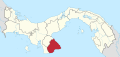
Las Tablas is the capital of the Panamanian province of Los Santos, with a population of 9,255 as of 2010. It is located a few kilometres inland from the Gulf of Panama on the Azuero Peninsula. Las Tablas is a recognised national centre of Panamanian folk: Art, music, gastronomy, architecture, culture and literature. The only Panamanian president to serve three terms, Belisario Porras, was from Las Tablas.
La Tiza is a town and corregimiento in Las Tablas District, Los Santos Province, Panama with a population of 1,702 as of 2010. Its population as of 1990 was 1,167; its population as of 2000 was 1,662.
Las Trancas is a village and corregimiento in Guararé District, Los Santos Province, Panama with a population of 511 as of 2010. It lies between Las Tablas and Pedasí. Its population as of 1990 was 605; its population as of 2000 was 525. It is celebrated for its Festival de la Candelaria, a religious ceremony held on 2 February every year, with folk dancing and music.
El Pedregoso is a corregimiento in Las Tablas District, Los Santos Province, Panama with a population of 279 as of 2010. Its population as of 1990 was 288; its population as of 2000 was 266.
Las Palmitas is a corregimiento in Las Tablas District, Los Santos Province, Panama with a population of 2,057 as of 2010. Its population as of 1990 was 1,046; its population as of 2000 was 1,404.
Bajo Corral is a corregimiento in Las Tablas District, Los Santos Province, Panama with a population of 483 as of 2010. Its population as of 1990 was 601; its population as of 2000 was 546.
Bayano is a corregimiento in Las Tablas District, Los Santos Province, Panama with a population of 660 as of 2010. Its population as of 1990 was 800; its population as of 2000 was 762.
El Carate is a corregimiento in Las Tablas District, Los Santos Province, Panama with a population of 873 as of 2010. Its population as of 1990 was 723; its population as of 2000 was 831.
El Cocal is a corregimiento in Las Tablas District, Los Santos Province, Panama with a population of 1,889 as of 2010. Its population as of 1990 was 1,239; its population as of 2000 was 1,486.
El Manantial is a corregimiento in Las Tablas District, Los Santos Province, Panama with a population of 909 as of 2010. Its population as of 1990 was 631; its population as of 2000 was 793.
El Muñoz is a corregimiento in Las Tablas District, Los Santos Province, Panama with a population of 376 as of 2010. Its population as of 1990 was 319; its population as of 2000 was 328.
La Laja is a corregimiento in Las Tablas District, Los Santos Province, Panama with a population of 547 as of 2010. Its population as of 1990 was 553; its population as of 2000 was 583.
La Miel is a corregimiento in Las Tablas District, Los Santos Province, Panama with a population of 290 as of 2010. Its population as of 1990 was 318; its population as of 2000 was 312.
La Palma is a corregimiento in Las Tablas District, Los Santos Province, Panama with a population of 1,247 as of 2010. Its population as of 1990 was 1,271; its population as of 2000 was 1,280.
Nuario is a corregimiento in Las Tablas District, Los Santos Province, Panama with a population of 182 as of 2010. Its population as of 1990 was 229; its population as of 2000 was 195.
Palmira is a corregimiento in Las Tablas District, Los Santos Province, Panama.
Peña Blanca is a corregimiento in Las Tablas District, Los Santos Province, Panama with a population of 875 as of 2010. Its population as of 1990 was 582; its population as of 2000 was 750.
Río Hondo is a corregimiento in Las Tablas District, Los Santos Province, Panama with a population of 206 as of 2010. Its population as of 1990 was 299; its population as of 2000 was 254.
San José is a corregimiento in Las Tablas District, Los Santos Province, Panama with a population of 593 as of 2010. Its population as of 1990 was 593; its population as of 2000 was 640.
Sesteadero is a corregimiento in Las Tablas District, Los Santos Province, Panama with a population of 1,067 as of 2010. Its population as of 1990 was 801; its population as of 2000 was 869.