Contents

National parks in Panama include: [1] [2]
National parks in Panama include: [1] [2]

Central America is a subregion of the Americas. Its boundaries are defined as bordering Mexico to the north, Colombia to the south, the Caribbean Sea to the east, and the Pacific Ocean to the west. Central America usually consists of seven countries: Belize, Costa Rica, El Salvador, Guatemala, Honduras, Nicaragua, and Panama. Within Central America is the Mesoamerican biodiversity hotspot, which extends from northern Guatemala to central Panama. Due to the presence of several active geologic faults and the Central America Volcanic Arc, there is a high amount of seismic activity in the region, such as volcanic eruptions and earthquakes which has resulted in death, injury, and property damage.

Panama, officially the Republic of Panama, is a transcontinental country spanning the southern part of North America and the northern part of South America. It is bordered by Costa Rica to the west, Colombia to the southeast, the Caribbean Sea to the north, and the Pacific Ocean to the south. Its capital and largest city is Panama City, whose metropolitan area is home to nearly half the country's 4 million people.
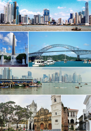
Panama City, also known as Panama, is the capital and largest city of Panama. It has a total population of 1,938,000, with over 1,500,189 in its urban area. The city is located at the Pacific entrance of the Panama Canal, in the province of Panama. The city is the political and administrative center of the country, as well as a hub for banking and commerce.
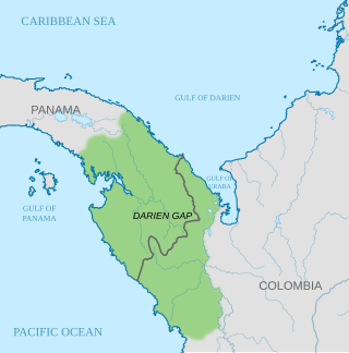
The Darién Gap is a geographic region in the Isthmus of Darien or Isthmus of Panama connecting the North and South American continents within Central America, consisting of a large watershed, forest, and mountains in Panama's Darién Province and the northern portion of Colombia's Chocó Department.

Bocas del Toro (Spanish pronunciation: [ˈbokaz ðel ˈtoɾo]; meaning "Mouths of the Bull") is a province of Panama. Its area is 4,643.9 square kilometers, comprising the mainland and nine main islands. The province consists of the Bocas del Toro Archipelago, Bahía Almirante, Chiriquí Lagoon, and adjacent mainland. The capital is the city of Bocas del Toro on Isla Colón. Other major cities or towns include Almirante and Changuinola. The province has a population of 125,461 as of 2010.
Coclé is a province of central Panama on the nation's southern coast. The administrative capital is the city of Penonomé. This province was created by the Act of September 12, 1855 with the title of Department of Coclé during the presidency of Dr. Justo de Arosemena. It became a province, Decretory Number 190, on October 20, 1985. Coclé is primarily an agricultural area, with sugar and tomatoes as major crops. The province has a number of well-known beaches, such as Santa Clara, Farallon and Rio Hato, and tourist activity has increased in recent years. It covers an area of 4,946.6 sq.km, and had a population of 265,149 in 2019.

Los Santos is a province in Panama, reaching from the La Villa river in the North to the Pacific Ocean in the south and east. It is part of the Azuero Peninsula, bounded by the province of Herrera to the north and northeast, and by Mariato District of Veraguas Province to the West. The City of Las Tablas is the capital and most populous city. There are seven administrative districts under the jurisdiction of Los Santos Province. Los Santos's area is 3,809.4 km ², and its population is 95,540 inhabitants in 2019.

Veraguas is a province of Panama, located in the centre-west of the country. The capital is the city of Santiago de Veraguas. It is the only Panamanian province to border both the Atlantic and Pacific oceans. It covers an area of 10,587.6 km² and in 2019 it had an estimated population of 247,644.

The Panama–California Exposition was an exposition held in San Diego, California, between January 1, 1915, and January 1, 1917. The exposition celebrated the opening of the Panama Canal, and was meant to tout San Diego as the first United States port of call for ships traveling north after passing westward through the canal. The fair was held in San Diego's large urban Balboa Park.

The Florida Panhandle is the northwestern part of the U.S. state of Florida; it is a salient roughly 200 miles (320 km) long and 50 to 100 miles wide, lying between Alabama on the north and the west, Georgia on the north, and the Gulf of Mexico to the south. Its eastern boundary is arbitrarily defined. In terms of population, major communities include Tallahassee, Pensacola, and Panama City.

The Volcán Barú is an active stratovolcano and the tallest mountain in Panama, at 3,474 metres (11,398 ft) high. It lies about 35 km (22 mi) off the border of Costa Rica. It is also the twelfth highest peak in Central America.

The Chagres River, in central Panama, is the largest river in the Panama Canal's watershed. The river is dammed twice, and the resulting reservoirs—Gatun Lake and Lake Alajuela—form an integral part of the canal and its water system. Although the river's natural course runs northwest to its mouth at the Caribbean Sea, its waters also flow, via the canal's locks, into the Gulf of Panama to the south. The Chagres thus has the unusual claim of drainage into two oceans.
Darién National Park is a World Heritage Site in Panama. It is about 325 kilometers from Panama City, and is the most extensive of all national parks of Panama and is one of the most important world heritage sites in Central America.

Los Katíos National Natural Park is a protected area located in northwest Colombia which covers about 720 km2 (280 sq mi). The elevation ranges between 50 and 600 m. It is a part of the Darién Gap, a densely forested area shared by Panama and Colombia, and is contiguous with the Darién National Park in Panama. The Pan-American Highway, when completed as proposed, would pass near or through Los Katíos. The park was declared a UNESCO World Heritage Site in 1994 due to the extraordinary diversity of plant and animal species represented.

The Cordillera de Talamanca is a mountain range that lies in the southeast half of Costa Rica and the far west of Panama. Much of the range and the area around it is included in La Amistad International Park, which also is shared between the two countries.

Governor Stone is a historic schooner, built in 1877, in Pascagoula, Mississippi, United States. She is the only surviving two-masted coasting cargo schooner built on the Gulf Coast of the United States, and is only one of five such surviving US-built ships. On 4 December 1991, she was added to the US National Register of Historic Places. One year later, the schooner was designated a US National Historic Landmark. She is presently berthed at Saint Andrews Marina in Panama City, Florida, where she is maintained by a nonprofit group. Sailing tours are regularly scheduled.
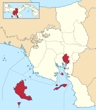
Montijo District is a district (distrito) of Veraguas Province in Panama. The population according to the 2000 census was 12,211; the latest official estimate is 7,060. The district covers a total area of 780 km². It includes all of the offshore islands of Coiba National Park, the largest of which are Coiba and Jicarón. The capital lies at the town of Montijo. The district includes the Gulf of Montijo and the islands in it.
Protected areas of Panama include:

The Panama Papers are 11.5 million leaked documents that were published beginning on April 3, 2016. The papers detail financial and attorney–client information for more than 214,488 offshore entities. The documents, some dating back to the 1970s, were created by, and taken from, former Panamanian offshore law firm and corporate service provider Mossack Fonseca, and compiled with similar leaks into a searchable database.