Costa Rica is located on the Central American Isthmus, surrounding the point 10° north of the equator and 84° west of the prime meridian. It has 212 km of Caribbean Sea coastline and 1,016 on the North Pacific Ocean.

Los Santos is a province in Panama, reaching from the La Villa river in the North to the Pacific Ocean in the south and east. It is part of the Azuero Peninsula, bounded by the province of Herrera to the north and northeast, and by Mariato District of Veraguas Province to the West. The City of Las Tablas is the capital and most populous city. There are seven administrative districts under the jurisdiction of Los Santos Province. Los Santos's area is 3,809.4 km ², and its population is 95,540 inhabitants in 2019.

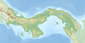
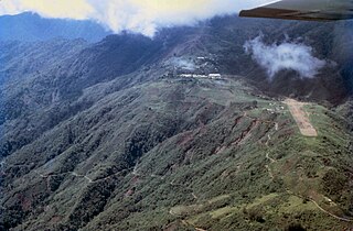
The Cordillera de Talamanca is a mountain range that lies in the southeast half of Costa Rica and the far west of Panama. Much of the range and the area around it is included in La Amistad International Park, which also is shared between the two countries.

The great green macaw, also known as Buffon's macaw or the great military macaw, is a Central and South American parrot found in Nicaragua, Honduras, Costa Rica, Panama, Colombia and Ecuador. Two allopatric subspecies are recognized; the nominate subspecies, Ara ambiguus ssp. ambiguus, occurs from Honduras to Colombia, while Ara ambiguus ssp. guayaquilensis appears to be endemic to remnants of dry forests on the southern Pacific coast of Ecuador. The nominate subspecies lives in the canopy of wet tropical forests and in Costa Rica is usually associated with the almendro tree, Dipteryx oleifera.

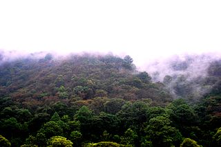
The Talamancan montane forests ecoregion, in the tropical moist broadleaf forest biome, are in montane Costa Rica and western Panama in Central America.

The Costa Rican páramo, also known as the Talamanca páramo, is a natural region of montane grassland and shrubland of Costa Rica and western Panama.

The wildlife of Cameroon is composed of its flora and fauna. Bordering Nigeria, it is considered one of the wettest parts of Africa and records Africa's second highest concentration of biodiversity. To preserve its wildlife, Cameroon has more than 20 protected reserves comprising national parks, zoos, forest reserves and sanctuaries. The protected areas were first created in the northern region under the colonial administration in 1932; the first two reserves established were Mozogo Gokoro Reserve and the Bénoué Reserve, which was followed by the Waza Reserve on 24 March 1934. The coverage of reserves was initially about 4 percent of the country's area, rising to 12 percent; the administration proposes to cover 30 percent of the land area.

The glow-throated hummingbird is an Endangered species of hummingbird in tribe Mellisugini of subfamily Trochilinae, the "bee hummingbirds". It is endemic to a small area of Panama.

The Azuero dove or brown-backed dove is a species of bird in the family Columbidae. It is endemic to Panama.
The Central American pine–oak forests is a tropical and subtropical coniferous forests ecoregion in the mountains of northern Central America and Chiapas state in southern Mexico.

Punta Mariato or Mariato Point is a cape in western Panama and is the southernmost point on the mainland of North America and is one of the Extreme points of Earth.

The Isthmian–Atlantic moist forests (NT0129) are a Central American tropical moist broadleaf forest ecoregion located on the lowland slopes on the caribbean sea side of Nicaragua and Costa Rica and the Gulf and Pacific Ocean sides of Panama. The forest species are a mix of North American and South American, as this region only became a land bridge in the past 3 million years.
The Huon Peninsula montane rain forests is a tropical moist forest ecoregion in New Guinea. The ecoregion covers the mountains of northeastern New Guinea's Huon Peninsula.

The La Amistad International Park, or in Spanish Parque Internacional La Amistad, formerly the La Amistad National Park, is a Transboundary Protected Area in Latin America, management of which is shared between Costa Rica and Panama, following a recommendation by UNESCO after the park's inclusion in the World Heritage Site list in 1983. The park and surrounding Biosphere Reserve is one of the most outstanding conservation areas in Central America, preserving a major tract of tropical forest wilderness. It is world-renowned for its extraodinary biodiversity and endemism.

The Central American montane forests are an ecoregion of the tropical and subtropical moist broadleaf forests biome, as defined by the World Wildlife Fund, located in mountains of Central America.

The Bolivian montane dry forests (NT0206) is an ecoregion in Bolivia on the eastern side of the Andes. It is a transitional habitat between the puna grasslands higher up to the west and the Chaco scrub to the east. The habitat is under severe stress from a growing human population.

The Magdalena–Urabá moist forests (NT0137) is an ecoregion in the north of Colombia. The terrain is largely flat or undulating, but includes mountainous areas in the south. It contains moist forests and large wetlands that are important to resident and migratory birds. The ecoregion forms a bridge between the Pacific coast ecoregions of Colombia and Central America, and the ecoregions of the Andes and Amazon. It is surrounded by the more populated parts of Colombia and is threatened by farming, ranching, logging, oil exploitation and water pollution in the main rivers.

The Chocó–Darién moist forests (NT0115) is an ecoregion in the west of Colombia and east of Panama. The region has extremely high rainfall, and the forests hold great biodiversity. The northern and southern parts of the ecoregion have been considerably modified for ranching and farming, and there are threats from logging for paper pulp, uncontrolled gold mining, coca growing and industrialisation, but the central part of the ecoregion is relatively intact.

The Eastern Panamanian montane forests (NT0122) is an ecoregion in the east of Panama and the extreme northwest of Colombia. It contains diverse flora and fauna, with considerable endemism. The ecoregion is largely intact due to its inaccessibility, although the opening of an extension of the Pan-American Highway has introduced threats from human activity.

The Veracruz montane forests is a tropical moist broadleaf forest ecoregion in eastern Mexico. It includes a belt of montane tropical forest on the eastern slope of the southern Sierra Madre Oriental and eastern Trans-Mexican Volcanic Belt ranges. These forests lie between the lowland Veracruz moist forests and the pine-oak forests of the higher mountains.