
This is a list of cities in South America .
This is a list of cities in South America .
This list includes the fifty largest cities in South America by population within city limits, based on the most recent official census results, estimates, or short-term projections available for all of these cities, which refer to mid-2020 populations, except for those of Chilean cities (2017) and Venezuelan cities (2015). The figures do not reflect the populations of urban agglomeration or metropolitan area, which typically do not coincide with the administrative boundaries of the city.
Bold represents largest city in country, Italic represents national capital city.
| Name | Image | Country | Population | Year | |
|---|---|---|---|---|---|
| 1 | São Paulo |  | 11,904,961 [1] | 2025 | |
| 2 | Lima |  | 10,092,000 [a] [2] | 2023 | |
| 3 | Bogotá |  | 7,862,277 [b] [4] | 2024 | |
| 4 | Rio de Janeiro |  | 6,730,729 [1] | 2025 | |
| 5 | Santiago |  | 6,254,314 [c] [5] | 2017 | |
| 6 | Caracas |  | 3,289,886 [d] [6] | 2015 | |
| 7 | Buenos Aires |  | 3,121,707 [7] | 2022 | |
| 8 | Brasília |  | 2,996,899 [1] | 2025 | |
| 9 | Medellín |  | 2,657,772 [b] [4] | 2024 | |
| 10 | Guayaquil |  | 2,650,288 [8] | 2022 | |
| 11 | Fortaleza |  | 2,578,483 [1] | 2025 | |
| 12 | Salvador |  | 2,564,204 [1] | 2025 | |
| 13 | Belo Horizonte |  | 2,415,872 [1] | 2025 | |
| 14 | Manaus |  | 2,303,732 [1] | 2025 | |
| 15 | Cali |  | 2,270,293 [b] [4] | 2024 | |
| 16 | Curitiba |  | 1,830,795 [1] | 2025 | |
| 17 | Quito | 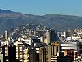 | 1,763,275 [8] | 2022 | |
| 18 | Maracaibo |  | 1,653,211 [6] | 2015 | |
| 19 | Santa Cruz de la Sierra |  | 1,606,671 [9] | 2024 | |
| 20 | Recife |  | 1,588,376 [1] | 2025 | |
| 21 | Córdoba |  | 1,505,250 [10] | 2022 | |
| 22 | Goiânia |  | 1,503,256 [1] | 2025 | |
| 23 | Belém |  | 1,397,315 [1] | 2025 | |
| 24 | Porto Alegre |  | 1,388,794 [1] | 2025 | |
| 25 | Guarulhos | | 1,349,100 [1] | 2025 | |
| 26 | Rosario |  | 1,348,725 [11] | 2022 | |
| 27 | Barranquilla |  | 1,341,160 [b] [4] | 2024 | |
| 28 | Montevideo |  | 1,302,954 [12] | 2023 | |
| 29 | Campinas |  | 1,187,974 [1] | 2025 | |
| 30 | Callao |  | 1,171,400 [2] | 2023 | |
| 31 | Arequipa |  | 1,157,500 [e] [2] | 2023 | |
| 32 | Barquisimeto |  | 1,116,182 [6] | 2015 | |
| 33 | São Luís | 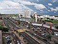 | 1,089,215 [1] | 2025 | |
| 34 | Trujillo |  | 1,034,300 [f] [2] | 2023 | |
| 35 | Maceió |  | 994,952 [1] | 2025 | |
| 36 | Campo Grande |  | 962,883 [1] | 2025 | |
| 37 | São Gonçalo |  | 960,196 [1] | 2025 | |
| 38 | Cartagena |  | 950,011 [b] [4] | 2024 | |
| 39 | Teresina | | 905,692 [1] | 2025 | |
| 40 | Valencia |  | 901,900 [6] | 2015 | |
| 41 | João Pessoa |  | 897,633 [1] | 2025 | |
| 42 | El Alto |  | 885,035 [9] | 2024 | |
| 43 | Ciudad Guayana |  | 877,547 [6] | 2015 | |
| 44 | Duque de Caxias | 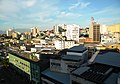 | 866,225 [1] | 2025 | |
| 45 | Nova Iguaçu |  | 843,220 [1] | 2025 | |
| 46 | São Bernardo do Campo |  | 841,154 [1] | 2025 | |
| 47 | Natal |  | 784,249 [1] | 2025 | |
| 48 | Santo André |  | 782,048 [1] | 2025 | |
| 49 | La Plata |  | 768,547 [14] | 2022 | |
| 50 | La Paz |  | 755,732 [9] | 2024 |
| City proper | |
|---|---|
| Metropolitan area | |
| Urban area/agglomeration | |
| Historical | |
| Related articles | |