This is a list of cities in Oceania (including Australia) with a population of over 80,000. National and territorial capitals are shown in bold type.
Contents
| City | Country | Urban area | Notes | Image |
|---|---|---|---|---|
| Sydney | 5,361,466 | Estimated resident population, June 2021 [1] |  | |
| Melbourne | 5,096,298 | Estimated resident population, June 2021 [1] |  | |
| Brisbane | 2,568,927 | Estimated resident population, June 2021 [1] |  | |
| Perth | 2,099,530 | Significant Urban Area, June 2021 [1] |  | |
| Auckland | 1,797,300 | Urban area provisional resident population, June 2025 [2] |  | |
| Adelaide | 1,469,163 | Significant Urban Area, June 2024 [1] |  | |
| Honolulu | 1,016,508 | Urban Honolulu Metropolitan Statistical Area, 2020 census [3] |  | |
| Gold Coast | 718,772 | Significant Urban Area, June 2021 [1] | 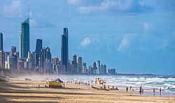 | |
| Christchurch | 556,500 | Metropolitan area provisional New Zealand resident population, June 2025 [2] |  | |
| Newcastle–Maitland | 505,489 | Significant Urban Area, June 2021 [1] |  | |
| Canberra –Queanbeyan | 462,984 | Significant Urban Area, June 2021 [1] | | |
| Wellington –Hutt Valley–Porirua | 432,600 | Metropolitan area provisional New Zealand resident population, June 2025 [2] |  | |
| Jayapura | 414,862 | National census 2020 [4] |  | |
| Port Moresby | 364,145 | National census 2011 |  | |
| Sunshine Coast | 353,906 | Significant Urban Area, June 2021 [1] |  | |
| Central Coast | 338,567 | Significant Urban Area, June 2021 [1] | | |
| Wollongong | 312,167 | Significant Urban Area, June 2021 [1] |  | |
| Geelong | 287,704 | Significant Urban Area, June 2021 [1] | 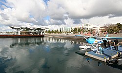 | |
| Sorong | 284,410 | National census 2020 [4] |  | |
| Hobart | 218,386 | Significant Urban Area, June 2021 [1] |  | |
| Townsville | 184,271 | Significant Urban Area, June 2021 [1] |  | |
| Nouméa | 179,509 | Metropolitan area. National census, August 2014 [5] |  | |
| Hamilton | 178,500 | Urban area provisional New Zealand resident population, June 2025 [2] |  | |
| Cairns | 155,529 | Significant Urban Area, June 2021 [1] |  | |
| Tauranga | 155,200 | Urban area provisional New Zealand resident population, June 2025 [2] |  | |
| Toowoomba | 140,303 | Significant Urban Area, June 2021 [1] |  | |
| Papeete | 136,771 | Urban area. National census, August 2017 [6] |  | |
| Napier-Hastings Urban Area | 134,500 | Urban area provisional New Zealand resident population, June 2025 [2] |  | |
| Dunedin | 133,300 | Urban area provisional New Zealand resident population, June 2025 [2] |  | |
| Darwin | 132,921 | Significant Urban Area, June 2021 [1] |  | |
| Ballarat | 111,348 | Significant Urban Area, June 2021 [1] |  | |
| Bendigo | 103,575 | Significant Urban Area, June 2021 [1] |  | |
| Lae | 100,677 | National census 2011 |  | |
| Mandurah | 98,883 | Significant Urban Area, June 2023 [1] |  | |
| Albury–Wodonga | 97,274 | Significant Urban Area, June 2021 [1] |  | |
| Palmerston North | 90,500 | Urban area provisional New Zealand resident population, June 2025 [2] |  | |
| Launceston | 88,884 | Significant Urban Area, June 2021 [1] |  | |
| Suva | 87,000 | National census 2019 |  | |
| Honiara | 84,520 | National census 2017 |  | |