List of largest cities in Central America

Last updated

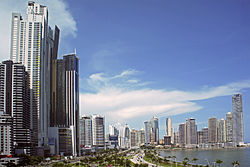
The two lists of the largest cities in Central America given below are based on two different definitions of a city, the urban agglomeration, and the city proper. In both lists Central America is defined as consisting of Belize, Guatemala, Honduras, El Salvador, Nicaragua, Costa Rica and Panama. All estimates and projections given have a reference date of mid-2015.

Contents

Guatemala City, the largest urban agglomeration in Central America Plaza Espana, Ciudad de Guatemala.jpg
Guatemala City, the largest urban agglomeration in Central America
Panama City, the second largest agglomeration in Central America Panama 08 2013 7035.jpg
Panama City, the second largest agglomeration in Central America
San Jose, the third largest agglomeration in Central America 4- Vue San Jose.jpg
San José, the third largest agglomeration in Central America

Largest urban agglomerations

Estimates for all agglomerations with 300,000 or more inhabitants are included. [1] Projections are as of 2022.

CityPopulationCountry
Guatemala City 3,036,000Flag of Guatemala.svg  Guatemala
Panama City 1,938,000 [a] Flag of Panama.svg  Panama
Tegucigalpa 1,527,000Flag of Honduras.svg  Honduras
San José 1,441,000Flag of Costa Rica.svg  Costa Rica
San Salvador 1,111,000 [b] Flag of El Salvador.svg  El Salvador
Managua 1,083,000Flag of Nicaragua.svg  Nicaragua
San Pedro Sula 956,000Flag of Honduras.svg  Honduras
Alajuela 398,000Flag of Costa Rica.svg  Costa Rica
Heredia 348,000Flag of Costa Rica.svg  Costa Rica

Largest cities proper

All cities proper with a population of 200,000 or more are included. Estimates are as of 2015.

CityPopulationCountry
Guatemala City 1,221,739 [3] Flag of Guatemala.svg  Guatemala
Tegucigalpa 1,190,230 [4] Flag of Honduras.svg  Honduras
San Salvador 1,116,052 [5] Flag of El Salvador.svg  El Salvador
Managua 1,039,290 [6] Flag of Nicaragua.svg  Nicaragua
San Pedro Sula 742,118 [4] Flag of Honduras.svg  Honduras
Villa Nueva 564,686 [7] Flag of Guatemala.svg  Guatemala
Mixco 495,079 [7] Flag of Guatemala.svg  Guatemala
Panama City 468,843 [c] [9] Flag of Panama.svg  Panama
San Miguelito 355,429 [9] Flag of Panama.svg  Panama
San José 333,980 [10] Flag of Costa Rica.svg  Costa Rica
Soyapango 280,435 [11] Flag of El Salvador.svg  El Salvador
Santa Ana 269,386 [11] Flag of El Salvador.svg  El Salvador
San Miguel 257,621 [11] Flag of El Salvador.svg  El Salvador
Choloma 242,973 [4] Flag of Honduras.svg  Honduras
San Juan Sacatepéquez 237,245 [7] Flag of Guatemala.svg  Guatemala
León 204,985 [6] Flag of Nicaragua.svg  Nicaragua
La Ceiba 204,140 [4] Flag of Honduras.svg  Honduras

See also

Notes

  1. Refers to the population of urban localities in the districts of Panamá, Arraiján, La Chorrera and San Miguelito. [2]
  2. Refers to the urban parts of the municipios of San Salvador, Mejicanos, Soyapango, Delgado, Ilopango, Cuscatancingo, Ayutuxtepeque and San Marcos. [2]
  3. Panama's National Statistics and Census Institute (INEC) defines the city proper of Panama City as comprising the corregimientos of San Felipe, El Chorrillo, Santa Ana, Calidonia, Curundú, Betania, Bella Vista, Pueblo Nuevo, San Francisco, Parque Lefevre, Río Abajo, Juan Diaz and Pedregal. [8]

Related Research Articles

<span class="mw-page-title-main">Provinces of the Dominican Republic</span> First-level administrative divisions of the Dominican Republic

The Dominican Republic is divided into thirty-one provincias, while the national capital, Santo Domingo, is contained within its own Distrito Nacional.

<span class="mw-page-title-main">Provinces of Panama</span> First-level administrative divisions of Panama

Panama is divided into ten provinces and four provincial-level indigenous regions.

<span class="mw-page-title-main">Emberá-Wounaan Comarca</span> Indigenous region of Panama

Emberá-Wounaan is a comarca indígena in eastern Panama. It was created by Law Number 22 on November 8, 1983, out of the former Chepigana and Pinogana districts of the Darién Province. Its capital is Unión Chocó, and it is notable for being composed of two non-contiguous sections. 12,358 people lived here in 2023, with over 95% of them being indigenous peoples.

Talamanca is a canton in the Limón province of Costa Rica. The head city is Bribri, located in Bratsi district.

La Unión is a canton in the Cartago province of Costa Rica. The head city is in Tres Ríos district.

Mata Redonda is a district of the San José canton, in the San José province of Costa Rica.

<span class="mw-page-title-main">Pavas</span> District in San José canton, San José province, Costa Rica

Pavas is the ninth district of the San José canton, in the San José province of Costa Rica. The district comprises Tobías Bolaños International Airport, San José's domestic airport.

Hatillo is the tenth district of the San José canton, in the San José province of Costa Rica.

<span class="mw-page-title-main">Chepigana District</span> District in Darién Province, Panama

Chepigana District is a district (distrito) of Darién Province in Panama. The population according to the 2000 census was 27,461, and had risen to 30,110 in the 2010 census, prior to the creation of Santa Fe District. Since the separation of Santa Fe District, Chepigana covers a total area of 4,625.1 square kilometres (1,785.8 sq mi). The capital lies at the town of La Palma.

Cañas Dulces is a district of the Liberia canton, in the Guanacaste province of Costa Rica.

Los Castillos is a corregimiento in Río de Jesús District, Veraguas Province, Panama with a population of 552 as of 2010.

Quitirrisí is the seventh district of the Mora canton, in the San José province of Costa Rica.

Pozos is a district in Santa Ana canton, San José province of Costa Rica. It was created in 1907. The principal avenue of the district carries the name of Lindora, which is also used to name the district and its surroundings.

<span class="mw-page-title-main">Santa Fe District, Darién</span> District in Darién, Panama

Santa Fe is a district in the Panamanian province of Darién, located approximately 155 kilometres (96 mi) east of Panama City. The district seat is located at Santa Fe.

References

  1. "World Urbanization Prospects - Population Division - United Nations". population.un.org. Retrieved 2022-08-03.
  2. 1 2 World Urbanization Prospects: The 2014 Revision (Report). United Nations, Department of Economic and Social Affairs, Population Division. June 2014. Archived from the original on 2018-07-06. Retrieved 2015-06-03.
  3. Citypopulation.de Archived 2021-01-07 at the Wayback Machine
  4. 1 2 3 4 "El INE te cuenta: principales resultados del censo a nivel departamental y municipios". INE Honduras . Retrieved 2016-04-05.
  5. "San Salvador Population 2023". worldpopulationreview.com. Retrieved 2023-05-07.
  6. 1 2 Anuario Estadístico 2015 (PDF) (Report). INIDE. February 2016. pp. 51–52. Retrieved 2017-12-01.
  7. 1 2 3 Guatemala: Estimaciones de la Población total por municipio. Período 2008-2020. (al 30 de junio) (PDF) (Report). Instituto Nacional de Estadistica Guatemala. Archived from the original (PDF) on 2015-04-04. Retrieved 2015-06-03.
  8. "Cuadro 11. SUPERFICIE, POBLACIÓN Y DENSIDAD DE POBLACIÓN EN LA REPÚBLICA, SEGÚN PROVINCIA, COMARCA INDÍGENA, DISTRITO Y CORREGIMIENTO: CENSOS DE 1990 A 2010". Resultados Finales Básicos (Report). Instituto Nacional de Estadística y Censo, Contraloría General de la República de Panamá. Archived from the original on 2015-07-10. Retrieved 2015-06-03.
  9. 1 2 "Boletín 16. Estimaciones y proyecciones de la Población Total del País, por Provincia, Comarca Indígena, Distrito y corregimiento, según sexo y edad: años 2010-20". Instituto Nacional de Estadística y Censo, Contraloría General de la República de Panamá. Retrieved 2015-06-03.
  10. "2011-2025. Proyecciones distritales. Población total por grupos de edades, según provincia y cantón". INEC . Retrieved 2017-12-01.
  11. 1 2 3 El Salvador: Estimaciones y Proyecciones de Población Municipal 2005-2025 (Revisión 2014) (Report). Dirección General de Estadística y Censos. September 2014. Retrieved 2015-06-03.