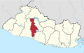
Aguilares is a municipality in the San Salvador department of El Salvador, located 33 km away from the city of San Salvador. The municipality measures 33.72 km² and as of 2006, had an estimated population of 73,300. Sugar cane cultivation is the major economic activity for the area.
Cuscatancingo is a municipality in the San Salvador department of El Salvador. It is located about 4 kilometres (2.5 mi) from the city of San Salvador and has a population of about 50,000.

El Paisnal is a municipality in the San Salvador department of El Salvador.
Guazapa is a municipality in the San Salvador department of El Salvador.
Ilopango is a town in the San Salvador department of El Salvador. It is a few miles east of the nation's capital, San Salvador. It is located near Lake Ilopango, the country's largest lake at 72 square kilometers.

Mejicanos is a San Salvador suburb in the San Salvador department of El Salvador.

Santiago Texacuangos is a municipality in the San Salvador department of El Salvador.
Soyapango is a municipality in the San Salvador department of El Salvador. Soyapango is a commercial center. The municipality is the third most populated area in the country, with 290,412 inhabitants. Soyapango is a satellite city of San Salvador and it is the main thoroughfare between San Salvador and the eastern part of the country, and nearly 70,000 vehicles travel through it every day. The nickname for this satellite city is Soya. The city is infamously and notoriously known for being the most dangerous city of the Central America region, and also for being a breeding ground for the Mara gangs and the place where gang members first arrive after being deported to El Salvador from Los Angeles, reason why these two locations evoke a similar resemblance to each other.

Sesori is a municipality in the Department of San Miguel, El Salvador. This is where many of the local people come and get food, supplies, education and it is also here where they get transportation to larger cities. Its location was used by other surrounding villages as people came here to make use of telephone services provided by ANTEL.

Nahulingo is a municipality in the Sonsonate department of El Salvador.
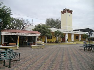
San Antonio del Monte is a municipality in the Sonsonate department of El Salvador. The town was founded at the beginning of the 18th century by the friars of the convent of Santo Domingo of Sonsonate. It is located at 230 meters of height and at a kilometer to the west of the city of Las Palmeras. The image of San Antonio has always possessed a miraculous fame since maidens in their prayers request for a boyfriend to marry.
Asunción Mita is a town, with a population of 20,936 (2018), and a municipality in the Jutiapa department of Guatemala.

Acajutla is a seaport city in Sonsonate Department, El Salvador. The city is located at 13°35′24″N89°50′01″W on the Pacific coast of Central America and is El Salvador's principal seaport from which a large portion of the nation's exports of coffee, sugar, and Balsam of Peru are shipped. As a city, Acajutla is one of seventeen such districts in Sonsonate. As of 1992, the population of the city was 18,008.

San Andrés is a pre-Columbian site in El Salvador, whose occupation began around the year 900 BC as an agricultural town in the valley of Zapotitán in the department of La Libertad. This early establishment was vacated by the year 250 because of the enormous eruption of the caldera of Lago Ilopango, and was occupied again in the 5th Century, along with many other sites in the valley of Zapotitán. Between 600 and 900 AD, San Andrés was the capital of a Maya polity with supremacy over the other establishments of Valle de Zapotitán.
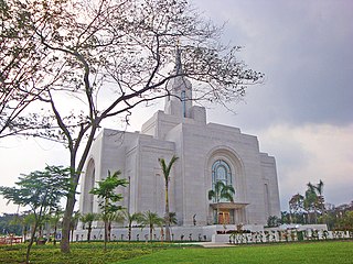
The San Salvador El Salvador Temple is the 135th temple of The Church of Jesus Christ of Latter-day Saints. It is the fourth temple to be built in Central America and the first in El Salvador.

The Lempa River is a 422-kilometre (262 mi) long river in Central America.

Casa Blanca is a pre-Columbian Maya archeological site in Chalchuapa, El Salvador. The site possesses several pyramids dating to the Late Preclassic period and the Classic period. This ruin is part of the Chalchuapa archaeological zone and displays influences from the Olmecs and from Teotihuacan. It is closely related to the ruins of Tazumal and San Andrés. The government purchased the park in 1977 and it was given the name of the coffee plantation upon which it was situated. There are many pyramids at Casa Blanca but only two have been partially restored. Casa Blanca is located in the department of Santa Ana. Casa Blanca has been closed to the public and is undergoing restoration work; it has a site museum with exhibits that include Maya ceramics and other artifacts.

Estadio Nacional Jorge "Mágico" González is a football stadium in San Salvador. It is named after Salvadorean star player Jorge Alberto González. The stadium has a capacity of 35,000 and was previously known as "Estadio Nacional Flor Blanca", referring to the name of the San Salvador neighborhood where it is located.
Chilanga is a municipality in the Morazán department of El Salvador.
The Apastepeque Volcanic Field is in El Salvador, Central America. The volcanic field is 8 kilometers north of a small town in central El Salvador called San Vicente. The last eruption of the volcano is unknown, however scientists have concluded that it was around 10, 000 years ago.
This page is based on this
Wikipedia article Text is available under the
CC BY-SA 4.0 license; additional terms may apply.
Images, videos and audio are available under their respective licenses.