Central American montane forests

Last updated
Central American montane forests
Pinus hartwegii Tajumulco 2.jpg
Central American montane forest,
with Pinus hartwegii , on the slopes of Tajumulco volcano, Guatemala.
Ecoregion NT0112.png
Ecoregion territory (in purple)
Ecology
Realm Neotropical
Biome tropical and subtropical moist broadleaf forests
Borders Central American pine–oak forests and Central American Atlantic moist forests
Geography
Area13,200 km2 (5,100 sq mi)
Countries
Conservation
Conservation status Vulnerable [1]
Protected31.34% [2]

The Central American montane forests are an ecoregion of the tropical and subtropical moist broadleaf forests biome, as defined by the World Wildlife Fund, located in mountains of Central America. [1]

Contents

Geography

Central American montane forests consist of forest patches located at altitudes ranging from 1,800–4,000 metres (5,900–13,100 ft), on the summits and slopes of the highest mountains in Central America, including the Sierra Madre de Chiapas. It extends from Chiapas state in southeastern Mexico, through Guatemala, El Salvador, and Honduras, to northern Nicaragua.

The montane forests ecoregion is surrounded at lower elevations by the Central American pine–oak forests, except for the enclaves in northern Guatemala, northern Honduras, and central Nicaragua, which are bounded by the Central American Atlantic moist forests.

The ecoregion covers an area of 13,200 square kilometres (5,100 sq mi)2. [1] The ecoregion has a temperate climate with relatively high precipitation levels. [1]

Climate

The climate is humid and montane. Average annual rainfall ranges from 2000 to 4000 millimeters, with many areas experiencing regular heavy cloud cover. At the highest elevations, regular nighttime frosts occur between December and March. [1]

Flora

Plant communities include lower montane wet forest, lower montane moist forest, montane forest, and subalpine grassland. [1]

The Guatemalan subalpine grassland plant community occurs above 3,050 m (10,000 ft) on the high volcanoes on the border between Guatemala and Mexico's Chiapas state, including Volcán Tacaná and Volcán Tajumulco. On Tacaná, subalpine grasslands occur above a belt of Juniperus standleyi shrubs that define the treeline at about 4000 meters elevation. The subalpine grasslands are dominated by Lupinus montanus and tussocks of the grass Calamagrostis vulcanica growing up to 1 meter high. Other grasses and herbaceous plants include Alchemilla pinnata, Arenaria bryoides, Draba volcanica, Festuca tolucensis, Gentiana pumilio, Gnaphalium salicifolium, Haplopappus stolonifer, Lobelia nana, Luzula racemosa, Pernettya prostrata, Potentilla heterosepala, Viola nannei, Weldenia candida , and Werneria nubigena . Mosses form the ground layer, and the moss Racomitrium crispulum dominates rocky outcrops. Other subalpine grasses include Bromus carinatus, Briza rotunda, Festuca amplissima, Muhlenbergia gigantea, M. macroura, M. robusta, Piptochaetium virescens, Stipa ichu , and Trisetum irazuense . [3]

Fauna

The horned guan (Oreophasis derbianus) is an endemic bird. [1]

The narrow-nosed harvest mouse (Reithrodontomys tenuirostris) is endemic to the subalpine grasslands. [3]

Protected areas

31.34% of the ecoregion is in protected areas. [2] Protected areas include La Tigra National Park (242.4 km2), Cerro Saslaya National Park (150 km2), Lago de Yojoa Multiple Use Area (442.3 km2), Montecristo National Park (19.7 km2), Macizos de Peñas Blancas Natural Reserve (113.1 km2), Cordillera Dipilto and Jalapa Natural Reserve (412 km2), Cerro Kilambe Natural Reserve (101.3 km2), Cerro Tisey–Estanzuela Nature Reserve (93.4 km2), Montecristo Trifinio National Park (82.9 km2), and Celaque National Park (266.3 km2). [2]

Related Research Articles

Ecology of California

The ecology of California can be understood by dividing the state into a number of ecoregions, which contain distinct ecological communities of plants and animals in a contiguous region. The ecoregions of California can be grouped into four major groups: desert ecoregions, Mediterranean ecoregions, forested mountains, and coastal forests.

South Western Ghats montane rain forests

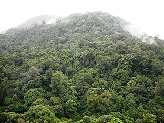
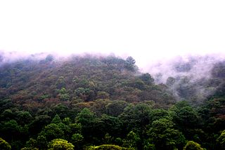
The South Western Ghats montane rain forests is an ecoregion in South India, covering the southern portion of the Western Ghats in Karnataka, Kerala and Tamil Nadu at elevations from 1,000 to 2,695 m. Annual rainfall in this ecoregion exceeds 2,800 mm (110 in).

Eastern Highlands Mountain range in Zimbabwe and Mozambique

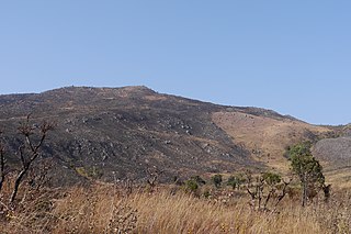
The Eastern Highlands, also known as the Manica Highlands, is a mountain range on the border of Zimbabwe and Mozambique. The Eastern Highlands extend north and south for about 300 kilometres (190 mi) through Zimbabwe's Manicaland Province and Mozambique's Manica Province.

Talamancan montane forests

The Talamancan montane forests ecoregion, in the tropical moist broadleaf forest biome, are in montane Costa Rica and Panama in Central America.

Petén–Veracruz moist forests Tropical moist broadleaf forest ecoregion in Belize, Guatemala, and Mexico

The Petén–Veracruz moist forests is an ecoregion of the tropical and subtropical moist broadleaf forest biome found in Belize, Guatemala, and Mexico.

Cameroonian Highlands forests

The Cameroonian Highlands forests, also known as the Cameroon Highlands forests, are a montane tropical moist broadleaf forest ecoregion located on the range of mountains that runs inland from the Gulf of Guinea and forms the border between Cameroon and Nigeria. This is an area of forest and grassland which is becoming increasingly more populous as more and more land is cleared for agriculture.

Trans-Mexican Volcanic Belt pine–oak forests Tropical and subtropical coniferous forests ecoregion in Mexico

The Trans-Mexican Volcanic Belt pine–oak forests is a subtropical coniferous forest ecoregion of the Trans-Mexican Volcanic Belt of central Mexico.

Central American pine–oak forests Ecoregion in Mexico and Central America

The Central American pine–oak forests is a tropical and subtropical coniferous forests ecoregion in the mountains of northern Central America and Chiapas state in southern Mexico.

Zacatonal Montane grasslands and shrublands ecoregion of central Mexico

The Zacatonal is a montane grassland and shrubland ecoregion of central Mexico.

Angolan montane forest–grassland mosaic

The Angolan montane forest-grassland mosaic ecoregion is located on the east-facing inland side of the belt of mountains that stands parallel to the coast of Angola, 50–100 km inland.

Ethiopian montane moorlands

The Ethiopian montane moorlands is a montane grasslands and shrublands ecoregion in Ethiopia. It lies above 3,000 meters elevation in the Ethiopian Highlands, the largest Afroalpine region in Africa. The montane moorlands lie above the tree line, and consist of grassland and moorland with abundant herbs and shrubs adapted to the high elevation conditions.

Central Range sub-alpine grasslands Ecoregion in New Guinea

The Central Range sub-alpine grasslands is a montane grasslands and shrublands ecoregion on the island of New Guinea. The ecoregion covers the highest-elevation portions of the New Guinea Highlands, which extend along the spine of the island. The high elevations support rare tropical sub-alpine and alpine habitats, including many endemic plants and animals.

East African montane forests

The East African montane forests is a montane tropical moist forest ecoregion of eastern Africa. The ecoregion comprises several separate areas above 2000 meters in the mountains of South Sudan, Uganda, Kenya, and Tanzania.

East African montane moorlands

The East African montane moorlands is a montane grasslands and shrublands ecoregion which occupies several high mountain peaks in Kenya, South Sudan, Tanzania, and Uganda.

Rwenzori–Virunga montane moorlands Montane ecoregion in central Africa

The Ruwenzori-Virunga montane moorlands is a montane grasslands and shrublands ecoregion of central Africa.

Chiapas Depression dry forests

The Chiapas Depression dry forests form one of the ecoregions that belong to the tropical and subtropical dry broadleaf forests biome, as defined by the World Wildlife Fund, in northwestern Central America.

Eastern Arc forests

The Eastern Arc forests is a montane tropical moist forest ecoregion of eastern Africa. The ecoregion comprises several separate highland areas above 800 meters in Kenya, and (mostly) Tanzania.

Ethiopian montane forests

The Ethiopian montane forests is a tropical moist broadleaf forest ecoregion in eastern Africa. It covers the middle elevations of the Ethiopian Highlands in Ethiopia and extends into neighboring Eritrea, Sudan, Djibouti, and Somaliland. The ecoregion includes distinctive Afromontane forests, woodlands, grasslands, and shrublands. The ecoregion's biodiversity is threatened by deforestation, conversion to agriculture, and overgrazing.

Chiapas montane forests Tropical moist broafleaf forest ecoregion of Chiapas, Mexico

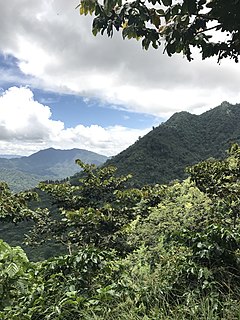
The Chiapas montane forests is a tropical moist broadleaf forest ecoregion in southern Mexico and extending into western Guatemala. It includes the montane tropical forests on the northern and northeastern slopes of the Chiapas highlands.

Sierra Madre de Chiapas moist forests Ecoregion in Mexico and Guatemala

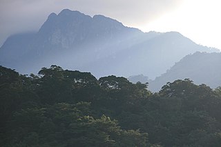
The Sierra Madre de Chiapas moist forests is a tropical moist broadleaf forest ecoregion in southern Mexico and southern Guatemala, extending into the northwestern corner of El Salvador.

References

  1. 1 2 3 4 5 6 7 "Central American montane forests". Terrestrial Ecoregions. World Wildlife Fund. Retrieved 2013-08-20.
  2. 1 2 3 "Central American montane forests" DOPA Explorer. Accessed 19 December 2020.
  3. 1 2 Brown, David E., and Markings, Elizabeth (2014). "A Guide to North American Grasslands" Desert Plants, Volume 29, Number 2, 2014.