
Central America is a subregion of North America. Its political boundaries are defined as bordering Mexico to the north, Colombia to the southeast, the Caribbean to the east, and the Pacific Ocean to the southwest. Central America is usually defined as consisting of seven countries: Belize, Costa Rica, El Salvador, Guatemala, Honduras, Nicaragua, and Panama. Within Central America is the Mesoamerican biodiversity hotspot, which extends from southern Mexico to southeastern Panama. Due to the presence of several active geologic faults and the Central America Volcanic Arc, there is a high amount of seismic activity in the region, such as volcanic eruptions and earthquakes, which has resulted in death, injury, and property damage.

Honduras is a country in Central America. Honduras borders the Caribbean Sea and the North Pacific Ocean. Guatemala lies to the west, Nicaragua south east and El Salvador to the south west. Honduras is the second largest Central American republic, with a total area of 112,777 square kilometres (43,543 sq mi).

Francisco Morazán is one of the departments of Honduras.
La Esperanza is the capital city and a municipality of the same name of the department of Intibucá, Honduras. La Esperanza is famous for having the coolest climate in Honduras. It is considered the heart of the Ruta Lenca, a region of Lenca ethnic influence that spans Honduras from Santa Rosa de Copan to Choluteca. Sites on the Lenca Trail have been designated by the government and United Nations development in order to encourage more cultural tourism, and help create new markets for the traditional crafts, such as pottery, practiced by the Lenca, in order to preserve their culture.

El Progreso is a city, with a population of 120,600, and a municipality located in the Honduran department of Yoro.

Valle de Ángeles is a municipality in the Honduran department of Francisco Morazán.

Madidi is a national park in the upper Amazon river basin in Bolivia. It was established in 1995 with a total land area of 18,958 km2. Together with the nearby protected areas Manuripi-Heath and Apolobamba and the Manu Biosphere Reserve (Peru), Madidi is part of one of the largest protected areas in the world.

Torres del Paine National Park is a national park encompassing mountains, glaciers, lakes, and rivers in southern Chilean Patagonia. The Cordillera del Paine is the centerpiece of the park. It lies in a transition area between the Magellanic subpolar forests and the Patagonian Steppes. The park is located 112 km (70 mi) north of Puerto Natales and 312 km (194 mi) north of Punta Arenas. The park borders Bernardo O'Higgins National Park to the west and the Los Glaciares National Park to the north in Argentine territory. Paine means "blue" in the native Tehuelche (Aonikenk) language and is pronounced PIE-neh. It was established as a National Park in 1959.
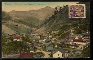
The New York and Honduras Rosario Mining Company (NYHRMC), known as Rosario Mining Company, was an American-owned corporation that owned and operated the Rosario mine, a gold and silver producer in central Honduras and Nicaragua.

San Juancito is a small town in central Honduras, located 40 km northeast of Tegucigalpa, the nation's capital. The town is in the department of Francisco Morazán. Including the dependent hamlets of Nuevo Rosario, Guacamaya, and Plan Grande, the population totals at about 1400. Its central neighborhood is depicted on the back of the 500-lempira bill.
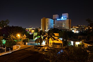
Tegucigalpa —formally Tegucigalpa, Municipality of the Central District, and colloquially referred to as Tegus or Teguz—is the capital and largest city of Honduras along with its sister city, Comayagüela.

Pico Bonito National Park is a national park in Honduras. It was established on January 1, 1987 and covers an area of 564.30 km2 (217.88 sq mi). It has an altitude ranging between 60 and 2,480 meters.
The Rosario and San Bernardo Corals National Natural Park is a natural park located in the Sucre and Bolívar Departments on the coast of the Caribbean Region of Colombia, 45 km from the Bay of Cartagena. It was the most visited national park in Colombia in 2009, with 318,473 visitors.

The Central American montane forests are an ecoregion of the tropical and subtropical moist broadleaf forests biome, as defined by the World Wildlife Fund, located in mountains of Central America.
The Central American dry forests ecoregion, of the tropical and subtropical dry broadleaf forests biome, is located in Central America.
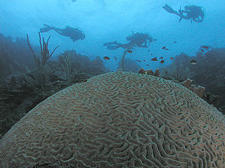
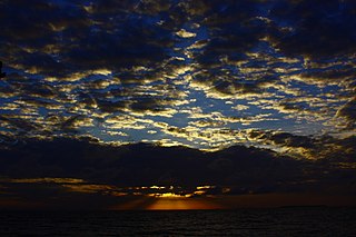
Honduras is a touristic destination that attracts visitors due to its natural environment, white and dark sand beaches, coral reefs, abundant flora and fauna, colonial era towns, and archaeological sites. Other attractions include the area's customs and traditional foods. In 2019 Honduras received 2.8 million foreigners, half of those tourists are cruise passengers.

Zov Tigra National Park, is a mountainous refuge for the endangered Amur Tiger. The park encompasses an area of 83,384 hectares on the southeast coast of Russia's Far East in the federal district Primorsky Krai. The park is about 100 km northeast of Vladivostok, on both the eastern and western slopes of the southern Sikhote-Alin mountain range, a range that runs north-south through the Primorsky Krai. The relatively warm waters of the Sea of Japan are to the east, the Korean peninsula to the south, and China to the West. The terrain in rugged and difficult to access, with heavily forested taiga coexisting with subtropical species of animals and birds. The park is relatively isolated from human development, and functions as a conservation reserve. Tourists may visit the portions of the park marked for recreation, but entry to the protected zones is only possible in the company of park rangers.
The network of highways in Honduras is managed by the Secretariat of public works, transport and housing (SOPTRAVI), through the General Directorate of Roads, which is responsible for planning construction and maintenance work on the country's roads. Honduras has more than 15,400 kilometres (9,600 mi) of roads. Up to 1999, only 3,126 kilometres (1,942 mi) had been paved.

The Northern Karst Belt is a limestone karst landscape located in the northwestern region of Puerto Rico. A karst is a topographical zone formed by the dissolution of soluble porous rocks, such as limestone, with features such as mogotes, canyons, caves, sinkholes, streams and rivers, all of which are common on this region of the island. Some of the island's main rivers, including its longest, traverse the karst and form some of the most distinctive Puerto Rican geographical features such as the Camuy caverns. Many of these rivers feed into and are important in the formation of many marshy areas such as the Caño Tiburones wetlands.

Comayagua International Airport, also known as Palmerola International Airport, is an international airport located 6 km (4 mi) south of the centre of Comayagua, Honduras. The airport was inaugurated in October 2021 as the country's new international airport for civil and commercial use. It was built at the facilities of the Soto Cano Air Base.


