
Olancho is the largest of all the 18 departments into which Honduras is divided. The department covers a total surface area of 24,057 km² and has an estimated 2015 population of 537,306 inhabitants.

The Río Plátano Biosphere Reserve is a protected area in the La Mosquitia region on the Caribbean coast of Honduras. With a total area of 5,250 square kilometers (2,030 sq mi), most of the reserve runs along the Río Plátano. The reserve has a number of endangered species and some of the largest remnants of tropical forest in Central America. It has been a World Heritage Site and biosphere reserve since 1982. In 2011, UNESCO placed the reserve on the List of World Heritage in Danger.

The Patuca is a river in northeastern Honduras, formed southeast of Juticalpa by the merger of the Guayape and Guayambre rivers. It is the second largest river in Central America and the longest river of Honduras, measuring almost 500 kilometres (310 mi) long and draining 23,900 square kilometres (9,200 sq mi).

Wampusirpi is a municipality in the Honduran department of Gracias a Dios.

Catacamas is a city, with a population of 63,310, and a municipality in the Olancho Department of Honduras.
Patuca is a municipality in the south of the Honduran department of Olancho, east of Juticalpa and south of Catacamas.

In Honduras, there is an important potential of untapped indigenous renewable energy resources. Due to the variability of high oil prices and declining renewable infrastructure costs, such resources could be developed at competitive prices.
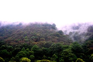
The Central American pine–oak forests is a tropical and subtropical coniferous forests ecoregion in the mountains of northern Central America and Chiapas state in southern Mexico.
Rosario Bank is a submerged former atoll in the southern Caribbean Sea, located less than 20 km south of Misteriosa Bank. It lies within Honduras's exclusive economic zone.

The Guayape River is a major river that drains much of the Department of Olancho and central Honduras. The largest tributary to the Guayape is the Río Jalán, which joins it at El Plomo, not far from the town of Juticalpa. From there the river passes many small towns, including El Esquilinchuche. The largest bridge over the Guayape is the Puente del Burro, a modern cement structure that replaced the huge steel suspension bridge that had stood for decades after being built by the US Army Corps of Engineers, and was destroyed by Hurricane Mitch in 1998. Far downriver from the bridge, the Guayape joins with the Guayambre River, from then on the waterway is known as the Río Patuca.
Water resources management (WRM) in Honduras is a work in progress and at times has advanced; however, unstable investment and political climates, strong weather phenomena, poverty, lack of adequate capacity, and deficient infrastructures have and will continue to challenge developments to water resource management. The State of Honduras is working on a new General Water Law to replace the 1927 Law on Using National Waters and designed to regulate water use and management. The new water law will also create a Water Authority, and the National Council of Water Resources which will serve as an advising and consultative body.
The Choluteca river basin lies on the hot and dry southern Pacific coast of Honduras, and is bordered by Nicaragua to the east. The name Choluteca, thought to mean ‘broad valley,’ originates from the indigenous Chorotega tribe who inhabited the region prior to Spanish conquest. The Choluteca river and its tributaries together form the Cabeceras catchment located in southern Honduras where it stretches over four administrative departments covering 7,848 km2 and drains into the Pacific Ocean. The Choluteca river basin provides water to the capital city of Tegucigalpa with population around 1 million inhabitants.

The Guayambre River is a river in Honduras. It is one of the two main tributaries of Honduras' longest river, the Patuca.

OroVerde – Die Tropenwaldstiftung is a non-profit environmental organisation working on the preservation of tropical forests. For this purpose, international projects are initiated, supported and realized in cooperation with local partner organisations. In Germany, environmental education projects are promoted and materials for teachers and pupils are created.
Juan Pablo Suazo Euceda is a Honduran author and agricultural engineer. He has spent more than ten years working in the La Mosquitia, a jungle region in north eastern Honduras. His first published work was Percepción y uso de la vida silvestre while his second book, a novel called Segovia, published in 2008, and named after the river of the same name found in La Mosquitia, won the 2008 Hibuera literary prize. He published a second book called Yalas en el mundo de Walamsa, is another novel based on the River Patuca, also in La Mosquitia region. His third book, published in 2013, is for children and is called Lea y las semillas de Kisanka.
The Central American Atlantic moist forests ecoregion covers the lowland coastal forests of Honduras, southeast Guatemala, and the eastern forests of Nicaragua. Half of the ecoregion is closed-canopy tropical broadleaf evergreen forest, with tree heights reaching 50 meters. This ecoregion has the largest single fragment of natural forest in Central America, with a size of 14,629 square kilometres (5,648 sq mi). The total area is 89,979 square kilometres (34,741 sq mi).
Tawahka Asagni Biosphere Reserve is a protected area in Honduras. The reserve was established in 1999, and covers an area of 2509.42 km2.
The Chortis Highlands is a highland region in northern Central America, which covers portions of Guatemala, El Salvador, Honduras, and Nicaragua.
