
Central America is a subregion of North America. Its political boundaries are defined as bordering Mexico to the north, Colombia to the south, the Caribbean Sea to the east, and the Pacific Ocean to the west. Central America is usually defined as consisting of seven countries: Belize, Costa Rica, El Salvador, Guatemala, Honduras, Nicaragua, and Panama. Within Central America is the Mesoamerican biodiversity hotspot, which extends from northern Guatemala to central Panama. Due to the presence of several active geologic faults and the Central America Volcanic Arc, there is a high amount of seismic activity in the region, such as volcanic eruptions and earthquakes, which has resulted in death, injury, and property damage.

A transboundary protected area (TBPA) is an ecological protected area that spans boundaries of more than one country or sub-national entity. Such areas are also known as transfrontier conservation areas (TFCAs) or peace parks.
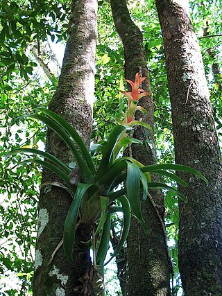
Magnolia guatemalensis is a tree found in the highlands and mountains of Guatemala, Chiapas, El Salvador, and Honduras. It is considered an indicator species of the cloud forest.

Ocotepeque is a municipality in the Honduran department of Ocotepeque. The town of Nueva Ocotepeque is the municipal seat and the capital of the department.
Concepción Las Minas is a municipality in southern Chiquimula department of Guatemala in Central America. It has a population of 11,693 (2018) and cover an area of 222 km2.
The 1989 CONCACAF Championship was the tenth and final edition of the CONCACAF Championship held under the format of serving as qualification to the 1990 FIFA World Cup and having no host nation for the final round. The tournament would be succeeded by the CONCACAF Gold Cup in 1991.
The Central American pine–oak forests is a tropical and subtropical coniferous forests ecoregion in the mountains of northern Central America and Chiapas state in southern Mexico.
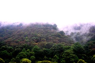
The Trifinio Fraternidad Transboundary Biosphere Reserve is a transboundary protected area located where the borders of El Salvador, Guatemala and Honduras meet. It protects the Montecristo massif and its cloud forests across the three countries' borders.
Under UNESCO’s Man and the Biosphere Programme, there are 125 biosphere reserves recognized as part of the World Network of Biosphere Reserves in Latin America and the Caribbean. These are distributed across 21 countries in the region.
Guatemala faces substantial resource and institutional challenges in successfully managing its national water resources. Deforestation is increasing as the global demand for timber exerts pressure on the forests of Guatemala. Soil erosion, runoff, and sedimentation of surface water is a result of deforestation from development of urban centers, agriculture needs, and conflicting land and water use planning. Sectors within industry are also growing and the prevalence of untreated effluents entering waterways and aquifers has grown alongside.

Montecristo National Park is a large national park centered on the Montecristo cloud forest in Mesoamerica. Montecristo National Park is located in the north-western tip of El Salvador, a country in Central America known for its wildlife diversity.

The Central American montane forests are an ecoregion of the tropical and subtropical moist broadleaf forests biome, as defined by the World Wildlife Fund, located in mountains of Central America.

The Central American dry forests ecoregion, of the tropical and subtropical dry broadleaf forests biome, is located in Central America.

Tourism accounts for a large part of El Salvador's economy. El Salvador has many natural attractions including beaches with some of the best surfing breaks on the Pacific Coast. El Salvador offers many lush forests shrouded in cool temperatures with abundant wildlife and scenic mountain-top vistas. El Salvador also has great potential in the field of cultural tourism; with over 2,000 known archaeological sites, mostly of the Maya and Olmec cultures. These sites are of international interest for their easy access and well-preserved remains.

The Guatemala–Honduras adjacency line is a disputed international boundary separating Guatemala on the north and west from Honduras on the south and east. The border dispute and being adjudicated in the ICJ as of 2019.

Quercus castanea is a species of oak tree. It is widespread across much of Mexico, from Sonora to Chiapas, and in Guatemala, El Salvador, and Honduras.
This is a list of the Honduras national football team results from 1960 to 1979.

The Northern Triangle of Central America (NTCA) is a term used in the United States to refer collectively to the three Central American countries of Guatemala, Honduras, and El Salvador. The term is used with respect to the countries' economic integration, and their shared challenges, including widespread poverty, violence, and corruption, which have prompted many to become refugees fleeing the three nations.
The Trifinio Biosphere Reserve is a protected area in Guatemala, located where the borders of Guatemala, El Salvador, and Honduras meet. The reserve was created in 1987, and has an area of 221.79 km2. It protects the Guatemalan portion of the Montecristo massif and its cloud forests, and is the Guatemalan portion of the Trifinio Fraternidad Transboundary Biosphere Reserve, which spans the three countries' borders.
The Chortis Highlands is a highland region in northern Central America, which covers portions of Guatemala, El Salvador, Honduras, and Nicaragua.
