Sierra Madre de Chiapas

Last updated
Sierra Madre
VolcanesdeGuatemala00 D.png
Volcanoes of the Sierra Madre in Guatemala
Highest point
Peak Volcán Tajumulco, Guatemala
Elevation 4,220 m (13,850 ft)
Coordinates 15°2′37″N91°54′11″W / 15.04361°N 91.90306°W / 15.04361; -91.90306
Geography
Outline map of Central America with borders.svg
Red triangle with thick white border.svg
Location in Central America
North America laea relief location map with borders.jpg
Red triangle with thick white border.svg
Location in North America
Countries Mexico, Guatemala, El Salvador and Honduras
Range coordinates 15°30′N92°36′W / 15.5°N 92.6°W / 15.5; -92.6
Geology
Orogeny Central America Volcanic Arc

The Sierra Madre is a major mountain range in Central America. It is known as the Sierra Madre de Chiapas in Mexico. It crosses El Salvador, Guatemala, Mexico and Honduras. The Sierra Madre is part of the American Cordillera, a chain of mountain ranges that consists of an almost continuous sequence of mountain ranges that form the western "backbone" of North America, Central America, and South America.

Contents

Geography

The range runs northwest–southeast from the state of Chiapas in Mexico, across western Guatemala, into El Salvador and Honduras. Most of the volcanoes of Guatemala, part of the Central America Volcanic Arc, are within the range.

A narrow coastal plain lies south of the range, between the Sierra Madre and the Pacific Ocean. To the north lie a series of highlands and depressions, including the Chiapas Depression, which separates the Sierra Madre from the Chiapas Plateau, the Guatemalan Highlands, and Honduras' interior highlands.

The range forms the main drainage divide between the Pacific and Atlantic river systems. On the Pacific side the distance to the sea is short, and the streams, while very numerous, are consequently small and rapid. A few of the streams of the Pacific slopes rise in the Guatemalan Highlands, and force a way through the Sierra Madre at the bottom of deep ravines. On the eastern side a number of the rivers of the Atlantic slopes attain a considerable volume and size.

The Sierra Madre moist forests ecoregion covers the southern slopes of the mountains. The mountains intercept winds from the Pacific, creating fog, clouds, and orographic precipitation that sustain the ecoregion's cloud forests. The Central American pine–oak forests ecoregion covers the Sierra's high peaks and northern slopes. [1]

Regional names

It is known near Guatemala city as the Sierra de las Nubes, and enters Mexico as the Sierra de Istatan. Its summit is not a well-defined crest, but is often rounded or flattened into a table-land. The direction of the great volcanic cones, which rise in an irregular line above it, is not identical with the main axis of the Sierra itself, except near the Mexican frontier, but has a more southerly trend, especially towards El Salvador.

Volcanoes

The base of many of the volcanic igneous peaks rests among the southern foothills in the southern region of the range. It is, however, impossible to subdivide the Sierra Madre into a northern and a volcanic chain; for the volcanoes are isolated by stretches of comparatively low country; at least thirteen considerable streams flow down through them, from the main watershed to the sea. Viewed from the coast, the volcanic cones seem to rise directly from the central heights of the Sierra Madre, above which they tower; but in reality their bases are, as a rule, farther south.

East of Volcán Tacana (4,092 metres) which marks the Mexican frontier, the principal volcanoes are Tajumulco (4,220 meters); Santa Maria (3,777 meters), which erupted in October 1902, after centuries of quiescence, in which its slopes had been overgrown by dense forests; Atitlan (3,557 meters), overlooking Lake Atitlan; Acatenango (3,976 meters); Fuego (i.e. "fire," 3,763 metres), which received its name from its activity at the time of the Spanish conquest; Agua (i.e. "water," 3,765 meters), so named in 1541 because it destroyed the former capital of Guatemala with a deluge of water from its flooded crater; and Pacaya (2,550 metres), a group of igneous peaks which were in eruption in 1870. East of the Guatemalan border, the range forms the boundary between El Salvador and Honduras. In El Salvador, the volcanoes form a line well south of the range, where over twenty volcanoes form five clusters. Between the Sierra Madre and the Volcanic line lies a central plateau.

Mirador La Pistola 050109.JPG
Sierra Madre de Chiapas in distance, near Quetzaltenango in Guatemala.
The mountain at left is the Volcán Siete Orejas (left) and Volcán Tajumulco (center).

See also

Related Research Articles

<span class="mw-page-title-main">Geography of El Salvador</span> Overview of countrys geological attributes

El Salvador is a country in Central America. Situated at the meeting point of three tectonic plates, it is highly seismologically active and the location of numerous earthquakes and volcanic eruptions. The country has a tropical climate.

<span class="mw-page-title-main">Geography of Guatemala</span> Set of physical features of Guatemala

Guatemala is mountainous, except for the south coastal area and the vast northern lowlands of Petén department. The country is located in Central America and bounded to the north and west by Mexico, to the east by Belize and by the Gulf of Honduras, to the east by Honduras, to the southeast by El Salvador, and to the south by the Pacific Ocean. Two mountain chains enter Guatemala from west to east, dividing the country into three major regions: the highlands, where the mountains are located; the Pacific coast, south of the mountains; and the limestone plateau of the Petén region, north of the mountains. These areas vary in climate, elevation, and landscape, providing dramatic contrasts between hot and humid tropical lowlands and highland peaks and valleys.

<span class="mw-page-title-main">Volcán Atitlán</span> Active volcano in Guatemala

Volcán Atitlán is a large, conical, active stratovolcano adjacent to the caldera of Lake Atitlán in the Guatemalan Highlands of the Sierra Madre de Chiapas range. It is within the Sololá Department, in southwestern Guatemala.

<span class="mw-page-title-main">Soconusco</span> Region in southern Chiapas, Mexico

Soconusco is a region in the southwest corner of the state of Chiapas in Mexico along its border with Guatemala. It is a narrow strip of land wedged between the Sierra Madre de Chiapas mountains and the Pacific Ocean. It is the southernmost part of the Chiapas coast extending south from the Ulapa River to the Suchiate River, distinguished by its history and economic production. Abundant moisture and volcanic soil has always made it rich for agriculture, contributing to the flowering of the Mokaya and Olmec cultures, which were based on Theobroma cacao and rubber of Castilla elastica.

<span class="mw-page-title-main">Geography of Mesoamerica</span>

The geography of Mesoamerica describes the geographic features of Mesoamerica, a culture area in the Americas inhabited by complex indigenous pre-Columbian cultures exhibiting a suite of shared and common cultural characteristics. Several well-known Mesoamerican cultures include the Olmec, Teotihuacan, the Maya, the Aztec and the Purépecha. Mesoamerica is often subdivided in a number of ways. One common method, albeit a broad and general classification, is to distinguish between the highlands and lowlands. Another way is to subdivide the region into sub-areas that generally correlate to either culture areas or specific physiographic regions.

<i>Abies guatemalensis</i> Species of conifer

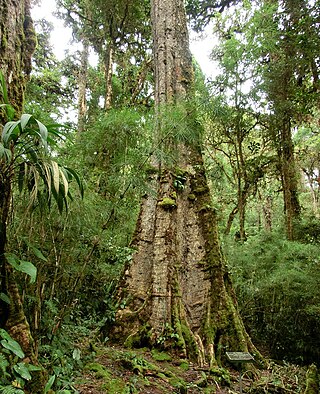
Abies guatemalensis, the Guatemalan fir or pinabete, is an evergreen tree native to Central America and is the southernmost member of the genus Abies being spread to the south lower than 14° N. Its range is from southern Mexico in the north to Honduras and El Salvador in the south. It is a warm-loving and moisture-loving tree of the tropical mountain coniferous and mixed cloud forests of these countries. The Guatemalan fir is an almost completely non-frost-resistant tree. Due to logging and loss of habitat, the tree is considered threatened and is protected in CITES Appendix I.

<span class="mw-page-title-main">Guatemalan Highlands</span> Geographical region of Mesoamerica

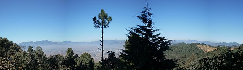
The Guatemalan Highlands is an upland region in southern Guatemala, lying between the Sierra Madre de Chiapas to the south and the Petén lowlands to the north.

<i>Podocarpus matudae</i> Species of conifer

Podocarpus matudae is a species of conifer in the family Podocarpaceae. It is found in Guatemala, El Salvador, Honduras and Mexico.

<i>Quercus skinneri</i> Species of flowering plant

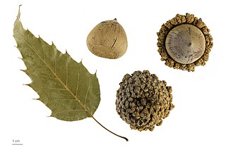
Quercus skinneri is a species of oak. It is found in Mexico, Guatemala, Honduras, and El Salvador. It is threatened by habitat loss.

<span class="mw-page-title-main">Central American pine–oak forests</span> Ecoregion in Mexico and Central America

The Central American pine–oak forests is a tropical and subtropical coniferous forests ecoregion in the mountains of northern Central America and Chiapas state in southern Mexico.

The Central America bioregion is a biogeographic region comprising southern Mexico and Central America.

<span class="mw-page-title-main">Central American montane forests</span> Ecoregion in Central America

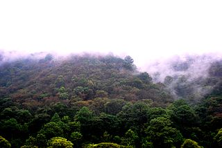
The Central American montane forests are an ecoregion of the tropical and subtropical moist broadleaf forests biome, as defined by the World Wildlife Fund, located in mountains of Central America.

<i>Quercus castanea</i> Species of oak tree

Quercus castanea is a species of oak tree. It is widespread across much of Mexico, from Sonora to Chiapas, and in Guatemala, El Salvador, and Honduras.

<i>Quercus elliptica</i> Species of oak tree

Quercus elliptica is a Mesoamerican species of oak tree. It is widespread across central and southern Mexico and Central America from Sinaloa and Hidalgo south as far as Nicaragua. It is classified in Quercus sect. Lobatae.

<i>Quercus sapotifolia</i> Species of oak tree

Quercus sapotifolia is a species of oak. It is native to southern and western Mexico as well as Central America. It is threatened by habitat loss.

<span class="mw-page-title-main">Sierra Madre de Chiapas moist forests</span> Ecoregion in Mexico and Guatemala

The Sierra Madre de Chiapas moist forests is a tropical moist broadleaf forest ecoregion in southern Mexico and southern Guatemala, extending into the northwestern corner of El Salvador.

Carpinus tropicalis is a species of tree native to central and southern Mexico, Guatemala, El Salvador, Honduras, and Nicaragua.

<i>Quercus segoviensis</i> Species of plant

Quercus segoviensis is a species of oak native to southern Mexico and northern Central America. It is commonly known as k’antulán.

<i>Cornus disciflora</i> Species of plant

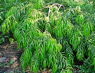
Cornus disciflora is a species of flowering plant native to Mexico and Central America.

Cornus excelsa is a species of flowering plant in the dogwood genus (Cornus). It is native to mountain forests of Mexico, Guatemala, and Honduras.

References

  1. "Sierra Madre de Chiapas moist forests". Terrestrial Ecoregions. World Wildlife Fund.