Geography of Honduras

Last updated
Geography of Honduras
Mapa Geografica de Honduras 33.PNG
Continent North America
Region Central America
Coordinates 15°00′N86°30′W / 15.000°N 86.500°W / 15.000; -86.500
Area Ranked 101st
  Total112,492 km2 (43,433 sq mi)
  Land99.82%
  Water0.18%
Coastline832 km (517 mi)
Borders1575 km (975 mi)
Highest point Cerro Las Minas
2,870 metres (9,420 ft)
Lowest point Caribbean Sea
0 metres (0 ft)
Longest river Ulúa
400 km (250 mi)
Largest lake Lake Yojoa
79 km2 (31 sq mi)
Exclusive economic zone249,542 km2 (96,349 sq mi)
A map of Honduras. Un-honduras.png
A map of Honduras.

Honduras is a country in Central America. Honduras borders the Caribbean Sea and the North Pacific Ocean. Guatemala lies to the west, Nicaragua south east and El Salvador to the south west. Honduras is the second largest Central American republic, with a total area of 112,890 square kilometres (43,590 sq mi).

Contents

Honduras has a 700-kilometer (430-mile) Caribbean coastline extending from the mouth of the Río Motagua in the west to the mouth of the Río Coco in the east, at Cape Gracias a Dios. [1] The 922 km (573 mi) southeastern side of the triangle is a land border with Nicaragua. [1] It follows the Río Coco near the Caribbean Sea and then extends southwestward through mountainous terrain to the Gulf of Fonseca on the Pacific Ocean. [1] The southern apex of the triangle is a 153 km (95 mi) coastline on the Gulf Fonseca, which opens onto the Pacific Ocean. [1] In the west there are two land borders: with El Salvador as 342 km long (213 mi) and with Guatemala as 256 km long (159 mi). [1]

Topography

Honduras' topography. Honduras Topography.png
Honduras' topography.

Honduras has three distinct topographical regions: an extensive interior highland area and two narrow coastal lowlands. [1] The interior, which constitutes approximately 80 percent of the country's terrain, is mountainous. [1] The larger Caribbean lowlands in the north and the Pacific lowlands bordering the Gulf of Fonseca are characterized by alluvial plains. [1]

Interior highlands

The interior highlands are the most prominent feature of Honduran topography. [1] This mountain area makes up about 80% of the country's area, and is home to the majority of the population. [1] Because the rugged terrain has made the land difficult to traverse and equally difficult to cultivate, this area has not been highly developed. [1] The soil here is poor: Honduras lacks the rich volcanic ash found in other Central American countries. [1] Until the early 20th century, the highland economy consisted primarily of mining and livestock. [1]

In the west, Honduras' mountains blend into the mountain ranges of Guatemala. [1] The western mountains have the highest peaks, with the Pico Congolón at an elevation of 2,500 metres (8,202 ft) and the Cerro Las Minas at 2,850 m (9,350 ft). [1] The Honduran border with El Salvador crosses the peak of Cerro El Pital, the highest point in El Salvador at over 2,730 m (8,957 ft). [2] These mountains are woodland covered with mainly pine forests. [1]

In the east, the mountains merge with those in Nicaragua. [1] Although generally not as high as the mountains near the Guatemalan border, the eastern ranges possess some high peaks, such as the Montaña de la Flor at 2,300 m (7,546 ft), El Boquerón (Monte El Boquerón) at 2,485 m (8,153 ft), and Pepe Bonito at 2,435 m (7,989 ft). [1]

One of the most prominent features of the interior highlands is a depression that runs from the Caribbean Sea to the Gulf of Fonseca. [1] This depression splits the country's cordilleras into eastern and western parts and provides a relatively easy transportation route across the isthmus. [1] Widest at its northern end near San Pedro Sula, the depression narrows as it follows the upper course of the Río Humuya. [1] Passing first through Comayagua and then through narrow passes south of the city, the depression widens again as it runs along the border of El Salvador into the Gulf of Fonseca. [1]

A economic activity map of Honduras, 1983. Honduras econ 1983.jpg
A economic activity map of Honduras, 1983.
A land use map of Honduras, 1983. Honduras land 1983.jpg
A land use map of Honduras, 1983.

Scattered throughout the interior highlands are numerous flat-floored valleys, at 300 to 900 meters (980 to 2,950 ft) in elevation, which vary in size. [1] The floors of the large valleys provide sufficient grass, shrubs, and dry woodland to support livestock and, in some cases, commercial agriculture. [1] Subsistence agriculture has been relegated to the slopes of the valleys, with the limitations of small-sized holdings, primitive technology, and low productivity that traditionally accompany hillside cultivation. [1] Villages and towns, including the capital, Tegucigalpa, are tucked in the larger valleys. [1]

Vegetation in the interior highlands is varied. [1] Much of the western, southern, and central mountains are open woodland; supporting pine forest interspersed with some oak, scrub, and grassy clearings. [1] The ranges toward the east are primarily continuous areas of dense, broad-leaf evergreen forest. [1] Around the highest peaks, remnants of dense rainforest that formerly covered much of the area are still found. [1]

Caribbean lowlands

This area of river valleys and coastal plains, which most Honduras call "the north coast," or simply "the coast," has traditionally been Honduras's most exploited region. [1] The central part of the Caribbean lowlands, east of La Ceiba, is a narrow coastal plain only a few kilometers wide. [1]

To the east and west of this section the Caribbean lowlands widen and in places extend inland a considerable distance along broad river valleys. [1] The broadest river valley, along the Río Ulúa near the Guatemalan border, is Honduras's most developed area. [1] Both Puerto Cortés, the country's largest port, and San Pedro Sula, Honduras's industrial capital, are located here, as is La Ceiba, the third largest city in the country. [1]

To the east, near the Nicaraguan border, the Caribbean lowlands broaden to an extensive area known as La Mosquitia. [1] Unlike the western part of the Caribbean lowlands, the Mosquitia is Honduras's least-developed area. [1] Underpopulated and culturally distinct from the rest of the country, the area consists of inland savannah with swamps and mangrove near the coast. [1] During times of heavy rainfall, much of the savannah area is covered by shallow water, making transportation by means other than a shallow-draft boat almost impossible. [1]

More than 46 campesinos from the Aguán Valley, in the far north-east of Honduras, have either been killed or have disappeared since the 2009 coup. [3] In the 1970s, government policy encouraged agricultural cooperatives and collectives to establish themselves in the lightly populated area, but after 1992 government policy favored privatization. [3] One of the biggest beneficiaries of the new policy and one of the richest men in Honduras, [4] Miguel Facussé, owned some 22,000 acres (8,900 ha) in the lower Aguán, which he planted in African palms for his palm oil venture.

Pacific lowlands

The smallest geographic region of Honduras, the Pacific lowlands, is a strip of land averaging twenty-five km wide (16 mi) on the north shore of the Gulf of Fonseca. [1] The land is flat, becoming swampy near the shores of the gulf, and is composed mostly of alluvial soils washed down from the mountains. [1] The gulf is shallow and the water rich in fish and mollusks. [1] Mangroves along the shore make shrimp and shellfish particularly abundant by providing safe and abundant breeding areas amid their extensive networks of underwater roots. [1]

Several islands in the gulf fall under Honduras's jurisdiction. [1] The two largest, Zacate Grande and El Tigre, are eroded volcanoes, part of the chain of volcanoes that extends along the Pacific coast of Central America. [1] Both islands have volcanic cones more than 700 m (2,300 ft) in elevation that serve as landmarks for vessels entering Honduras's Pacific. [1]

Islands

Honduras controls a number of islands as part of its offshore territories. [1] In the Caribbean Sea, the islands of Roatán (Isla de Roatán), Utila, and Guanaja together form the Islas de la Bahía (Bay Islands), one of the eighteen departments into which Honduras is divided. [1] Roatán, the largest of the three islands, is 50 by 5 km (31.1 by 3.1 mi). [1] The Islas de la Bahía archipelago also has a number of smaller islands, among them the islets of Barbareta (Isla Barbareta), Santa Elena (Isla Santa Elena), and Morat (Isla Morat). [1]

Farther out in the Caribbean are the Islas Santanillas, formerly known as Swan Islands. A number of small islands and keys can be found nearby, among them Cayos Zapotillos and Cayos Cochinos. [1] In the Gulf of Fonseca, the main islands under Honduran control are El Tigre, Zacate Grande (Isla Zacate Grande), and Exposición (Isla Exposición). [1]

Climate

Koppen climate types of Honduras Honduras Koppen.svg
Köppen climate types of Honduras

Honduras has a tropical climate and temperate climate in the highlands. [5]

The climatic types of each of the three physiographic regions differ. [1] The Caribbean lowlands have a tropical wet climate with consistently high temperatures and humidity, and rainfall fairly evenly distributed throughout the year. [1] The Pacific lowlands have a tropical wet and dry climate with high temperatures but a distinct dry season from November through April. [1] The interior highlands also have a distinct dry season, but, as is characteristic of a tropical highland climate, temperatures in this region decrease as elevation increases. [1]

Unlike in more northerly latitudes, temperatures in the tropics vary primarily with elevation instead of with the season. [1] Land below 1,000 meters (3,281 ft) is commonly known as tierra caliente (hot land), between 1,000 and 2,000 m (3,281 and 6,562 ft) as tierra templada (temperate land), and above 2,000 m (6,562 ft) as tierra fría (cold land). [1] Both the Caribbean and Pacific lowlands are tierra caliente, with daytime highs averaging between 28 and 32 °C (82.4 and 89.6 °F) throughout the year. [1]

In the Pacific lowlands, April, the last month of the dry season, brings the warmest temperatures; the rainy season is slightly cooler, although higher humidity during the rainy season makes these months feel more uncomfortable. [1] In the Caribbean lowlands, the only relief from the year-round heat and humidity comes during December or January when an occasional strong cold front from the north (a norte) brings several days of strong northwest winds and slightly cooler temperatures. [1]

The interior highlands range from tierra templada to tierra fría. Tegucigalpa, in a sheltered valley and at an elevation of 1,000 m (3,281 ft), has a pleasant climate, with an average high temperature ranging from 30 °C (86 °F) in April, the warmest month, to 25 °C (77 °F) in January, the coolest. [1] Above 2,000 meters (6,562 ft), temperatures can fall to near freezing at night, and frost sometimes occurs. [1]

Rain falls year round in the Caribbean lowlands but is seasonal throughout the rest of the country. Amounts are copious along the north coast, especially in the Mosquitia, where the average rainfall is 2,400 millimeters (94.5 in). [1] Nearer San Pedro Sula, amounts are slightly less from November to April, but each month still has considerable precipitation. [1] The interior highlands and Pacific lowlands have a dry season, known locally as "summer," from November to April. [1] Almost all the rain in these regions falls during the "winter," from May to September. [1] Total yearly amounts depend on surrounding topography; Tegucigalpa, in a sheltered valley, averages only 1,000 mm (39.4 in) of precipitation. [1]

Hurricanes

Honduras lies within the hurricane belt, and the Caribbean coast is particularly vulnerable to hurricanes or tropical storms that travel inland from the Caribbean. [1] Hurricane Francelia in 1969 and Tropical Storm Alleta in 1982 affected thousands of people and caused extensive damage to crops. [1] Hurricane Fifi in 1974 killed more than 8,000 and destroyed nearly the entire banana crop. [1]

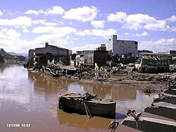
In 1998 Hurricane Mitch became the most deadly hurricane to strike the Western Hemisphere in the last two centuries. [6] This massive hurricane not only battered the Honduran coastline, but engulfed nearly the entire country with its powerful winds and torrential downpours. [7] Approximately 100,000 Hondurans were evacuated from the Caribbean coast. [7] Most of the Bay Islands had damage to their water facilities. [8]

Damage in Tegucigalpa from Hurricane Mitch Mitch-Tegucigalpa Damage.JPG
Damage in Tegucigalpa from Hurricane Mitch

The high rainfall caused many rivers in the country to overflow "to an unprecedented extent this century", as described by the United Nations. [9] Two earthflows caused significant damage near Tegucigalpa. [10] Hurricane Mitch wrought significant damage to Honduras, affecting nearly the entire population and causing damage in all 18 departments. [9] The United Nations Economic Commission for Latin America and the Caribbean estimated that Mitch caused the worst floods of the 20th century in the country. [11] Throughout Central America, Mitch claimed in excess of 11,000 lives, with thousands of others missing.

Hurricanes occasionally form over the Pacific and move north to affect southern Honduras, but Pacific storms are generally less severe and their landfall rarer. [1]

On September 4, 2007, Hurricane Felix made landfall at Honduras and Nicaragua, as a Category 5 hurricane. In November 2008, Hurricane Paloma, along with the October 2008 Central America floods, left at least 60 people dead and more than 300,000 in need of assistance. [12]

Drought

Drought in Honduras has become a driver of emigration, causing poor crop yields for poor subsistence farmers, and has been a factor in the formation of migrant caravans to the United States. [13] [14] [15] [16]

According to the FAO, migrants leaving central and western Honduras between 2014 and 2016 most frequently cited "no food" as their reason for leaving. [14]

Examples

Climate data for Tegucigalpa (Tegucigalpa Airport) 1961–1990, extremes 1951–present
MonthJanFebMarAprMayJunJulAugSepOctNovDecYear
Record high °C (°F)33.0
(91.4)
34.5
(94.1)
35.5
(95.9)
36.6
(97.9)
36.9
(98.4)
34.5
(94.1)
35.9
(96.6)
36.9
(98.4)
34.2
(93.6)
34.8
(94.6)
32.8
(91.0)
31.4
(88.5)
36.9
(98.4)
Mean daily maximum °C (°F)25.7
(78.3)
27.4
(81.3)
29.5
(85.1)
30.2
(86.4)
30.2
(86.4)
28.6
(83.5)
27.8
(82.0)
28.5
(83.3)
28.5
(83.3)
27.3
(81.1)
26.0
(78.8)
25.4
(77.7)
27.9
(82.2)
Daily mean °C (°F)19.5
(67.1)
20.4
(68.7)
22.1
(71.8)
23.4
(74.1)
23.6
(74.5)
22.6
(72.7)
22.1
(71.8)
22.4
(72.3)
22.2
(72.0)
21.5
(70.7)
20.4
(68.7)
19.7
(67.5)
21.7
(71.1)
Mean daily minimum °C (°F)14.3
(57.7)
14.5
(58.1)
15.5
(59.9)
17.1
(62.8)
18.2
(64.8)
18.2
(64.8)
18.0
(64.4)
18.0
(64.4)
17.9
(64.2)
17.6
(63.7)
16.3
(61.3)
15.0
(59.0)
16.7
(62.1)
Record low °C (°F)4.5
(40.1)
7.2
(45.0)
4.7
(40.5)
8.9
(48.0)
11.1
(52.0)
12.4
(54.3)
12.6
(54.7)
12.2
(54.0)
11.0
(51.8)
10.0
(50.0)
7.7
(45.9)
6.8
(44.2)
4.5
(40.1)
Average precipitation mm (inches)5.3
(0.21)
4.7
(0.19)
9.9
(0.39)
42.9
(1.69)
143.5
(5.65)
158.7
(6.25)
82.3
(3.24)
88.5
(3.48)
177.2
(6.98)
108.9
(4.29)
39.9
(1.57)
9.9
(0.39)
871.7
(34.32)
Average precipitation days (≥ 1.0 mm)11129129913104273
Average relative humidity (%)71666260677574737678777571
Mean monthly sunshine hours 220.8229.4268.5242.8216.3171.7192.5204.8183.4200.4199.2212.22,542
Source 1: NOAA [17]
Source 2: Deutscher Wetterdienst (humidity, 1951–1993) [18] Meteo Climat (record highs and lows) [19]
Climate data for San Pedro Sula (La Mesa International Airport) 1961–1990, extremes 1944–present
MonthJanFebMarAprMayJunJulAugSepOctNovDecYear
Record high °C (°F)37.2
(99.0)
39.5
(103.1)
42.8
(109.0)
42.0
(107.6)
42.0
(107.6)
41.1
(106.0)
38.0
(100.4)
38.8
(101.8)
39.2
(102.6)
37.8
(100.0)
37.5
(99.5)
37.0
(98.6)
42.8
(109.0)
Mean daily maximum °C (°F)29.2
(84.6)
30.4
(86.7)
33.0
(91.4)
34.0
(93.2)
35.2
(95.4)
34.3
(93.7)
33.3
(91.9)
33.4
(92.1)
33.5
(92.3)
31.6
(88.9)
30.2
(86.4)
29.2
(84.6)
32.3
(90.1)
Daily mean °C (°F)23.5
(74.3)
24.1
(75.4)
25.8
(78.4)
27.1
(80.8)
28.1
(82.6)
27.7
(81.9)
27.1
(80.8)
27.3
(81.1)
27.2
(81.0)
26.0
(78.8)
24.7
(76.5)
23.7
(74.7)
26.0
(78.8)
Mean daily minimum °C (°F)19.8
(67.6)
20.0
(68.0)
21.4
(70.5)
22.5
(72.5)
23.8
(74.8)
23.8
(74.8)
23.2
(73.8)
23.3
(73.9)
23.3
(73.9)
22.5
(72.5)
21.4
(70.5)
20.4
(68.7)
22.1
(71.8)
Record low °C (°F)12.8
(55.0)
10.0
(50.0)
13.4
(56.1)
15.0
(59.0)
20.2
(68.4)
17.0
(62.6)
18.9
(66.0)
18.9
(66.0)
18.9
(66.0)
13.9
(57.0)
15.0
(59.0)
12.8
(55.0)
10.0
(50.0)
Average precipitation mm (inches)72.0
(2.83)
59.6
(2.35)
32.0
(1.26)
32.1
(1.26)
62.9
(2.48)
142.4
(5.61)
110.2
(4.34)
105.7
(4.16)
151.7
(5.97)
147.8
(5.82)
135.3
(5.33)
121.7
(4.79)
1,173.4
(46.20)
Average precipitation days (≥ 1.0 mm)6534410101010109889
Average relative humidity (%)84817775747679797981838580
Mean monthly sunshine hours 186.0178.0238.7222.0220.1201.0210.8198.4183.0198.4156.0155.02,347.4
Mean daily sunshine hours 6.06.37.77.47.16.76.86.46.16.45.25.06.4
Source 1: NOAA [20]
Source 2: Deutscher Wetterdienst (sun and humidity), [21] Meteo Climat (record highs and lows) [22]
Climate data for La Ceiba, Honduras (Golosón International Airport) 1970–1990, extremes 1965–present
MonthJanFebMarAprMayJunJulAugSepOctNovDecYear
Record high °C (°F)32.8
(91.0)
34.8
(94.6)
35.4
(95.7)
36.0
(96.8)
38.0
(100.4)
37.0
(98.6)
35.7
(96.3)
38.0
(100.4)
36.0
(96.8)
34.6
(94.3)
33.6
(92.5)
34.0
(93.2)
38.0
(100.4)
Mean daily maximum °C (°F)27.0
(80.6)
27.6
(81.7)
29.0
(84.2)
30.1
(86.2)
31.3
(88.3)
31.3
(88.3)
30.8
(87.4)
30.9
(87.6)
30.6
(87.1)
29.5
(85.1)
28.2
(82.8)
27.3
(81.1)
29.5
(85.1)
Daily mean °C (°F)23.8
(74.8)
24.0
(75.2)
25.6
(78.1)
26.8
(80.2)
28.2
(82.8)
28.0
(82.4)
27.5
(81.5)
27.6
(81.7)
27.4
(81.3)
26.2
(79.2)
25.2
(77.4)
24.3
(75.7)
26.2
(79.2)
Mean daily minimum °C (°F)18.4
(65.1)
18.4
(65.1)
19.5
(67.1)
20.7
(69.3)
22.2
(72.0)
22.6
(72.7)
21.8
(71.2)
21.8
(71.2)
22.0
(71.6)
21.2
(70.2)
20.2
(68.4)
19.1
(66.4)
20.7
(69.3)
Record low °C (°F)13.2
(55.8)
12.0
(53.6)
11.5
(52.7)
12.0
(53.6)
14.2
(57.6)
19.0
(66.2)
17.5
(63.5)
16.8
(62.2)
18.9
(66.0)
16.7
(62.1)
12.1
(53.8)
12.6
(54.7)
11.5
(52.7)
Average rainfall mm (inches)305.2
(12.02)
330.0
(12.99)
225.2
(8.87)
120.5
(4.74)
76.9
(3.03)
154.6
(6.09)
174.9
(6.89)
197.3
(7.77)
203.3
(8.00)
423.8
(16.69)
539.6
(21.24)
478.9
(18.85)
3,230.2
(127.17)
Average rainy days (≥ 1.0 mm)11866410111312141312118
Average relative humidity (%)81838280798080807879848082
Mean monthly sunshine hours 170.5192.1217.0234.0213.9192.0201.5217.0174.0151.9144.0151.92,259.8
Mean daily sunshine hours 5.56.87.07.86.96.46.57.05.84.94.84.96.2
Source 1: NOAA [23]
Source 2: Deutscher Wetterdienst (sun and humidity) [24] Meteo Climat (record highs and lows) [25]

Climate change

Climate change in Honduras is a major challenge for Honduras as it is one of the countries which is most at risk from climate change. The frequency of natural disasters in Honduras, such as floods, mudslides, tropical storms and hurricanes, is expected to increase as climate change intensifies. [26] [27] Over 40 percent of Hondurans work in the agricultural sector, which is impacted by increasing temperatures and reduced rainfall. [28] However, agriculture could be dramatically impacted, which can hurt certain households in Honduras. Sanitation and food access is a major issue that is increasing due to climate change, as well as the loss of habitats for several endangered organisms. [29]

Hydrography

The Ulua River as seen from the air. The Ulua is perhaps the most economically important river in Honduras. Barra-de-los-rios-ulua y chamelecon.jpg
The Ulúa River as seen from the air. The Ulua is perhaps the most economically important river in Honduras.

Honduras is a water-rich country. [1] The most important river in Honduras is the Ulúa, which flows 400 km (250 mi) to the Caribbean through the economically important Valle de Sula. [1] Numerous other rivers drain the interior highlands and empty north into the Caribbean. [1] These other rivers are important, not as transportation routes, but because of the broad fertile valleys they have produced. [1] The Choluteca River runs south from Tegucigalpa through Choluteca and out at the Gulf of Fonseca.

Rivers also define about half of Honduras's international borders. [1] The Río Goascorán, flowing to the Gulf of Fonseca, and the Río Lempa define part of the border between El Salvador and Honduras. [1] The Coco River marks about half of the border between Nicaragua and Honduras. [1]

Despite an abundance of rivers, large bodies of water are rare. [1] Lago de Yojoa, located in the west-central part of the country, is the sole natural lake in Honduras. [1] This lake is twenty-two kilometers long and at its widest point measures fourteen kilometers. [1] Several large, brackish lagoons open onto the Caribbean in northeast Honduras. [1] These shallow bodies of water allow limited transportation to points along the coast. [1]

Statistics

border countries:
land use:

Extreme Points

Natural resources

The natural resources include: timbers, gold, silver, copper, lead, zinc, iron ore, antimony, coal, fish, and hydropower from the mountain rivers.

Natural hazards

Frequent mild earthquakes, damaging hurricanes, and floods along the Caribbean coast are examples of Honduran natural hazards.

Environmental issues

Deforestation poses a particular problem for Honduras; the goals of conserving endangered natural resources and promoting economic development has often been quite difficult to combine, which has resulted in conflicting policies that fail to protect forests. Honduras has suffered the greatest percentage loss of forest cover of any country in Latin America. The forests in Honduras are an important source of economic resources to finance government programs. The tropical forests in Honduras are diminishing rapidly due to poverty in the country. The majority of the population of Honduras see the forests as an obstacle to the expansion of ranching and agricultural activities, ignoring the significance that forests have for the society through protection of fauna, soils, recreation, purification of air, and the regulation of water sources. The urban population is also increasing rapidly over the years, which means that it has led to the clearing of land for farming and the farming of marginal soils in rural areas, as well as to uncontrolled development in the fringes of urban areas.

Illegal logging is also a major problem in Honduras. The majority of the production of timber in the country is illegal. According to the Center for International Policy and the Environmental Investigation Agency, the timber trade corruption involves politicians, timber companies, bureaucrats, mayors, and even the police. All of these factors contribute to deforestation and consequently to soil erosion. According to the Food and Agriculture Organization, Honduras lost 59,000 hectares of forest per year between 1990 and 2000.

Deforestation in regions dominated by tropical dry forests has advanced faster than regions dominated by other types of forests. Tropical dry forests have lower species richness compared to moist forests. However, tropical dry forests possess higher levels of endemic species, greater utility for humans, and also have a higher human population density. The effects of deforestation are more noticeable during tropical storms and hurricanes. In 1998, Hurricane Mitch killed thousands and also caused damage to the country. According to aerial surveys following the storm, mudslides were worse in deforested areas than forested areas. Many endangered species live in the forests of Honduras, and they may soon be extinct if deforestation continues. The climate has also changed because of the lack of trees in Honduras. This has caused the growing season for farmers to be shortened.

The ground in deforested areas is absorbing all the water as well. The largest source of freshwater in Honduras, Lake Yojoa, is on the verge of turning into a swamp. This is due to the high rate of pollution and logging as well. Lake Yojoa is also being polluted by heavy metals from local mining activities. Lake Yojoa is home to more than 400 species of birds, but the area surrounding the lake is suffering from deforestation and water pollution. However, not only Lake Yojoa is being polluted with heavy metals, nearby rivers and streams are also being polluted. [30] [31] [32] [33] [34]

See also

Related Research Articles

<span class="mw-page-title-main">Geography of Colombia</span> Overview of the geography of Colombia

The Republic of Colombia is situated largely in the north-west of South America, with some territories falling within the boundaries of Central America. It is bordered to the north-west by Panama; to the east by Brazil and Venezuela; to the south by Ecuador and Peru; and it shares maritime limits with Costa Rica, Nicaragua, Honduras, Jamaica, the Dominican Republic, and Haiti.

<span class="mw-page-title-main">Central America</span> Subregion of the Americas

Central America is a subregion of North America. Its political boundaries are defined as bordering Mexico to the north, Colombia to the south, the Caribbean Sea to the east, and the Pacific Ocean to the west. Central America is usually defined as consisting of seven countries: Belize, Costa Rica, El Salvador, Guatemala, Honduras, Nicaragua, and Panama. Within Central America is the Mesoamerican biodiversity hotspot, which extends from northern Guatemala to central Panama. Due to the presence of several active geologic faults and the Central America Volcanic Arc, there is a high amount of seismic activity in the region, such as volcanic eruptions and earthquakes, which has resulted in death, injury, and property damage.

<span class="mw-page-title-main">Geography of El Salvador</span> Overview of countrys geological attributes

El Salvador is a country in Central America. Situated at the meeting point of three tectonic plates, it is highly seismologically active and the location of numerous earthquakes and volcanic eruptions. The country has a tropical climate.

<span class="mw-page-title-main">Geography of Nicaragua</span> Geographical features of Nicaragua

Nicaragua is a country in Central America, bordering both the Caribbean Sea and the North Pacific Ocean, between Costa Rica and Honduras. Nicaragua is the largest country in Central America in square kilometers.

<span class="mw-page-title-main">Geography of Panama</span>

Panama is a country located in Caribbean, bordering both the Caribbean Sea and the Pacific Ocean, between Colombia and Costa Rica. Panama is located on the narrow and low Isthmus of Panama.

<span class="mw-page-title-main">Geography of Guatemala</span> Set of physical features of Guatemala

Guatemala is mountainous, except for the south coastal area and the vast northern lowlands of Petén department. The country is located in Central America and bounded to the north and west by Mexico, to the east by Belize and by the Gulf of Honduras, to the east by Honduras, to the southeast by El Salvador, and to the south by the Pacific Ocean. Two mountain chains enter Guatemala from west to east, dividing the country into three major regions: the highlands, where the mountains are located; the Pacific coast, south of the mountains; and the limestone plateau of the Petén region, north of the mountains. These areas vary in climate, elevation, and landscape, providing dramatic contrasts between hot and humid tropical lowlands and highland peaks and valleys.

<span class="mw-page-title-main">Hurricane Mitch</span> Category 5 Atlantic hurricane in 1998

Hurricane Mitch was the second-deadliest Atlantic hurricane on record. Mitch caused 11,374 fatalities in Central America in 1998, including approximately 7,000 in Honduras and 3,800 in Nicaragua due to cataclysmic flooding from the slow motion of the storm. It was the deadliest hurricane in Central American history, surpassing Hurricane Fifi–Orlene, which killed slightly fewer people in that area in 1974. Mitch was the deadliest Atlantic hurricane in the satellite era, and the second-deadliest on record in the Atlantic, only behind the Great Hurricane of 1780 which killed at least 22,000 people.

<span class="mw-page-title-main">Gulf of Fonseca</span> Gulf of the Pacific Ocean in El Salvador, Honduras, and Nicaragua

The Gulf of Fonseca, a part of the Pacific Ocean, is a gulf in Central America, bordering El Salvador, Honduras, and Nicaragua.

<span class="mw-page-title-main">1934 Central America hurricane</span> Category 2 Atlantic hurricane in 1934

The 1934 Central America hurricane was a deadly tropical cyclone during the 1934 Atlantic hurricane season which caused at least 506 fatalities in Central America. Its peak strength, attained while in the Gulf of Mexico, was equivalent to a Category 2 hurricane on the modern Saffir–Simpson scale. The storm's path was erratic, beginning in the Gulf of Honduras on June 4 shortly before making its first landfall in British Honduras as a tropical storm. It then took a looping course through Guatemala before reemerging into the Gulf of Honduras on June 8. The storm struck the northeastern Yucatán Peninsula as a hurricane on June 9, crossing into the western Gulf of Mexico where its course made another loop. An accelerated northward course followed, leading to the hurricane's landfall along the Louisiana coast on June 16. It weakened over land and transitioned into an extratropical cyclone on June 18, accelerating northeast towards the Canadian Maritimes thereafter.

<span class="mw-page-title-main">Geography of Mesoamerica</span>

The geography of Mesoamerica describes the geographic features of Mesoamerica, a culture area in the Americas inhabited by complex indigenous pre-Columbian cultures exhibiting a suite of shared and common cultural characteristics. Several well-known Mesoamerican cultures include the Olmec, Teotihuacan, the Maya, the Aztec and the Purépecha. Mesoamerica is often subdivided in a number of ways. One common method, albeit a broad and general classification, is to distinguish between the highlands and lowlands. Another way is to subdivide the region into sub-areas that generally correlate to either culture areas or specific physiographic regions.

Territorial disputes of Nicaragua include the territorial dispute with Colombia over the Archipelago of San Andrés, Providencia and Santa Catalina and Quita Sueño Bank. Nicaragua also has a maritime boundary dispute with Honduras in the Caribbean Sea and a boundary dispute over the Rio San Juan with Costa Rica.

The Central America bioregion is a biogeographic region comprising southern Mexico and Central America.

<span class="mw-page-title-main">Outline of Honduras</span> Overview of and topical guide to Honduras

The following outline is provided as an overview of and topical guide to Honduras:

<span class="mw-page-title-main">Index of Honduras-related articles</span>

The following is an alphabetical list of topics related to the Republic of Honduras.

Water resources management (WRM) in Honduras is a work in progress and at times has advanced; however, unstable investment and political climates, strong weather phenomena, poverty, lack of adequate capacity, and deficient infrastructures have and will continue to challenge developments to water resource management. The State of Honduras is working on a new General Water Law to replace the 1927 Law on Using National Waters and designed to regulate water use and management. The new water law will also create a Water Authority, and the National Council of Water Resources which will serve as an advising and consultative body.

<span class="mw-page-title-main">Effects of Hurricane Mitch in Honduras</span>

The effects of Hurricane Mitch in Honduras were destructive and deadly, resulting in the most significant flooding in Honduras in the 20th century. Hurricane Mitch, the strongest storm of the 1998 Atlantic hurricane season, formed on October 22, and after becoming a Category 5 hurricane, it weakened and struck Honduras on October 29. While near peak intensity, Mitch struck the offshore Guanaja island, where it nearly destroyed the mangrove forest. On the mainland, the hurricane dropped torrential rainfall, and many gauges were washed away in mountainous areas where unofficial rainfall totals were as high as 1900 mm (75 in). The highest official total was 928 mm (36.5 in) at Choluteca in southern Honduras, which was more than half of the annual precipitation average there. The rains caused widespread flooding and landslides, although impact from winds was not as severe.

<span class="mw-page-title-main">Hurricanes in Central America</span>

Central America is a region containing seven countries that connects the two continents of North America and South America.

The Chortis Highlands is a highland region in northern Central America, which covers portions of Guatemala, El Salvador, Honduras, and Nicaragua.

References

  1. 1 2 3 4 5 6 7 8 9 10 11 12 13 14 15 16 17 18 19 20 21 22 23 24 25 26 27 28 29 30 31 32 33 34 35 36 37 38 39 40 41 42 43 44 45 46 47 48 49 50 51 52 53 54 55 56 57 58 59 60 61 62 63 64 65 66 67 68 69 70 71 72 73 74 75 76 77 78 79 80 81 82 83 84 PD-icon.svg This article incorporates text from this source, which is in the public domain :Echeverri-Gent, Elisavinda (1995). Merrill, Tim (ed.). Honduras: a country study (3rd ed.). Washington, D.C.: Federal Research Division, Library of Congress. pp. 66–74. ISBN   0-8444-0836-0. OCLC   31434665.
  2. Jacques, Jaime (2015-02-17). Moon El Salvador. Avalon Publishing. ISBN   978-1-61238-593-8.
  3. 1 2 Dana Frank (October 21, 2011). "WikiLeaks Honduras: US Linked to Brutal Businessman". The Nation.
  4. Tracy Wilkinson (June 23, 2015). "Miguel Facusse dies at 90; colorful, ruthless Honduran tycoon".
  5. Zúniga Andrade, Edgardo (1978). Las variantes del clima tropical lluvioso en Honduras y las características del clima en el Golfo de Fonseca y su litoral. Tegucigalpa, D.C., Honduras, C.A: Banco Central de Honduras.
  6. Viets, Patricia (August 17, 2001). "NOAA delivers life-saving disaster-preparedness infrastructure and systems to Central America". ReliefWeb . Archived from the original on July 10, 2019. Retrieved July 10, 2019.
  7. 1 2 Juan Carlos Ulate (1998-10-29). "Hurricane Mitch at standstill, pounding Honduras". ReliefWeb. Reuters. Archived from the original on 2012-01-11. Retrieved 2012-01-05.
  8. Central America After Hurricane Mitch: The Challenge of Turning a Disaster into an Opportunity (Report). Inter-American Development Bank. 2000. Archived from the original on April 19, 2013. Retrieved 2013-05-22.
  9. 1 2 Economic Commission for Latin America and the Caribbean (1999-04-14). Honduras: Assessment of the Damage Caused by Hurricane Mitch, 1998 (PDF) (Report). United Nations. Archived from the original (PDF) on 2014-05-19. Retrieved 2013-05-23.
  10. Edwin L. Harp; Mario Castañeda; Matthew D. Held (2002). Landslides Triggered By Hurricane Mitch In Tegucigalpa, Honduras (PDF) (Report). United States Geological Survey. Archived (PDF) from the original on 2014-05-19. Retrieved 2013-05-24.
  11. Description of the Damage (PDF). Honduras: Assessment of the damage caused by hurricane Mitch, 1998. Implications for economic and social development and for the environment (Report). Economic Commission for Latin America and the Caribbean. April 1999. Archived (PDF) from the original on 2013-09-21. Retrieved 2013-06-07.
  12. "Hondurans face many months of struggle after deadly floods, UN aid wing says". ReliefWeb. United Nations News Service. November 18, 2008. Retrieved May 21, 2015.
  13. Biggs, Marcia; Galiano-Rios, Julia (2019-04-02). "Climate change is killing crops in Honduras – and driving farmers north". PBS NewsHour. Retrieved 2019-05-04.
  14. 1 2 Leutert, Stephanie (November 6, 2018). "How climate change is affecting rural Honduras and pushing people north". Washington Post . Retrieved 2019-05-04.
  15. "Honduras: Climate Change Refugees – ARTE Reportage". ARTE in English. Retrieved 2019-05-04.
  16. Markham, Lauren (2018-11-09). "The Caravan is a Climate Change Story". Pulitzer Center. Retrieved 2019-05-04.
  17. "Tegucigalpa Climate Normals 1961–1990". National Oceanic and Atmospheric Administration . Retrieved January 24, 2016.
  18. "Klimatafel von Tegucigalpa (Int. Flugh.) / Honduras" (PDF). Baseline climate means (1961–1990) from stations all over the world (in German). Deutscher Wetterdienst. Retrieved January 24, 2016.
  19. "Station Tegucigalpa" (in French). Meteo Climat. Retrieved 12 June 2016.
  20. "La Mesa Climate Normals 1961–1990". National Oceanic and Atmospheric Administration. Retrieved 24 January 2016.
  21. "Klimatafel von San Pedro Sula (La Mesa), Bez.Cortés / Honduras" (PDF). Baseline climate means (1961–1990) from stations all over the world (in German). Deutscher Wetterdienst. Retrieved 24 January 2016.
  22. "Station La Mesa" (in French). Meteo Climat. Retrieved 12 June 2016.
  23. "La Ceiba Climate Normals 1961–1990". National Oceanic and Atmospheric Administration. Retrieved January 24, 2016.
  24. "Klimatafel von La Ceiba, Bez. Atlántida / Honduras" (PDF). Baseline climate means (1961–1990) from stations all over the world (in German). Deutscher Wetterdienst. Retrieved January 24, 2016.
  25. "Station Goloson" (in French). Meteo Climat. Retrieved 12 June 2016.
  26. "Honduras | Global Climate Change". Climate Links, a Global Knowledge Portal for Climate and Development Practitioners. USAID. 2019. Retrieved 2019-05-04.
  27. CEPAL (Comisión Económica para América Latina y el Caribe); MiAmbiente; Secretaría de Energía, Recursos Naturales, Ambiente y Minas - Honduras [in Spanish] (2016). "La Economía del Cambio Climático en Honduras. Mensajes Clave 2016" (PDF) (in Spanish). p. 9.{{cite web}}: CS1 maint: multiple names: authors list (link)
  28. "How climate change affects the Honduran economy". Energy Transition. 2019-03-07. Retrieved 2019-05-04.
  29. McMahan, Caleb D.; Fuentes-Montejo, César E.; Ginger, Luke; Carrasco, Juan Carlos; Chakrabarty, Prosanta; Matamoros, Wilfredo A. (2020-07-29). "Climate change models predict decreases in the range of a microendemic freshwater fish in Honduras". Scientific Reports. 10 (1): 12693. doi:10.1038/s41598-020-69579-7. ISSN 2045-2322.
  30. Tucker, Christine (January–June 2005). "Comparative Spatial Analyses of Forest Conservation and Change in Honduras and Guatemala". Conservation & Society. 3 (1): 174–200.
  31. Bass, Joby (October 2005). "Message in the Plaza: Landscape, Landscaping, and Forest Discourse in Honduras". Geographical Review. 95 (4): 556–577. doi:10.1111/j.1931-0846.2005.tb00381.x. S2CID   161952241.
  32. "Honduras: Environmental Profile". rainforests.mongabay.com.
  33. Southworth, Jane (August 2001). "The Influence of Accessibility, Local Institutions, and Socioeconomic Factors on Forest Cover Change in the Mountains of Western Honduras" (PDF). Mountain Research and Development. 21 (3): 276–283. doi:10.1659/0276-4741(2001)021[0276:TIOALI]2.0.CO;2. S2CID   130401536.
  34. Zúniga Andrade, Edgardo (1990). El clima e historia de ciudades y pueblos de Honduras. Tegucigalpa: Graficentro Editores.