
Honduras is a country in Central America. Honduras borders the Caribbean Sea and the North Pacific Ocean. Guatemala lies to the west, Nicaragua south east and El Salvador to the south west. Honduras is the second largest Central American republic, with a total area of 112,777 square kilometres (43,543 sq mi).

Lempira is one of the 18 departments in Honduras. located in the western part of the country, it is bordered by the departments of Ocotepeque and Copán to the west, Intibucá to the east, and Santa Bárbara to the north. To its south lies the El Salvador–Honduras border. The departmental capital is Gracias.
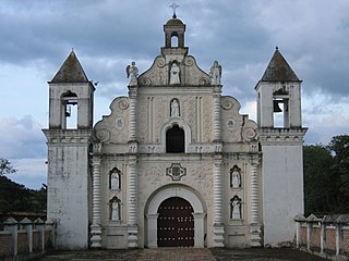
Gracias is a small Honduran town/municipality that was founded in 1536, and is the capital of Lempira Department.
Minas de Oro is a municipality in the Honduran department of Comayagua.

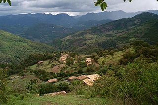
La Campa is a municipality and an aldea, or small town, in the Honduran Department of Lempira, located about 18 kilometres (11 mi) by dirt road from Gracias, the largest town in the immediate region.

Lauca National Park is in Chile's far north, within the Andean range. It encompasses an area of 1,379 km² of altiplano and mountains, the latter consisting mainly of enormous volcanoes. Las Vicuñas National Reserve is its neighbour to the south. Both protected areas, along with Salar de Surire Natural Monument, form Lauca Biosphere Reserve. The park borders Sajama National Park in Bolivia.

The Mountain Institute (TMI) is an international non-profit organization headquartered in Washington, D.C., and operates regional field offices in the Andes, Appalachians, and Himalayas. Respectively, these are the longest, the oldest, and the tallest mountain ranges in the world. TMI is the sole organization dedicated to conservation and development in mountain regions.
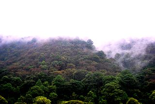
Celaque National Park is a national park in Lempira Ocotepeque and Copán, western Honduras. It was established on 5 August 1987 and covers an area of 266.31 square kilometres. It includes Honduras’ tallest peak, called Cerro Las Minas or Pico Celaque, which reaches approximately 2,870 metres (9,416 ft) above mean sea level. It has an elevation ranging from 975 to 2,870 metres. Celaque's terrain is very rugged, two-thirds of the area has a slope greater than 60 degrees. The park is classified as a cloud forest with a mean precipitation of 1,600 mm at lower altitudes and a mean of 2,400 mm at higher altitudes. The word celaque is reputed to mean caja de aguas in the local, but now extinct, indigenous Lenca language. Celaque's nine rivers supplies water to 120 villages nearby including the district capital of Gracias. Celaque is high in biodiversity and is home to pumas, ocelots and Bolitoglossa celaque, an endangered plethodontid salamander found only in the mountains of Celaque.

Paniri is a stratovolcano located in El Loa Province, Antofagasta Region, Chile, and near the border with Bolivia. To its northwest lie the twin volcanoes San Pedro and San Pablo, and to its southeast lies Cerro del León, from which it is separated by the huge Chao lava dome.
The Central American pine–oak forests is a tropical and subtropical coniferous forests ecoregion in the mountains of northern Central America and Chiapas state in southern Mexico.

The following outline is provided as an overview of and topical guide to Honduras:

The Khait or Hoit landslide occurred on July 10, 1949, in the Hoit district in the Gharm Oblast in the Tajik Soviet Socialist Republic, then part of the Soviet Union. 'Khait' is a transliteration from Russian: Хаит; the local modern spelling is Hoit.
Under UNESCO’s Man and the Biosphere Programme, there are 125 biosphere reserves recognized as part of the World Network of Biosphere Reserves in Latin America and the Caribbean. These are distributed across 21 countries in the region.

Heli hiking is a recreational activity in which a helicopter is used to access remote areas of the back country for hiking. These locations are typically inaccessible through other forms of transportation. Along with heli skiing, heli hiking is one of the most popular forms of heli tourism. It falls within the broad category of amateur adventure or activity-based tourism. It is a seasonal commercial backcountry industry, which also includes mountaineering and kayaking.

The Central American montane forests are an ecoregion of the tropical and subtropical moist broadleaf forests biome, as defined by the World Wildlife Fund, located in mountains of Central America.

The Sierra del Fraile, also known as "Cerro del Fraile", is a mountain and a protected area located in the García, Abasolo, Hidalgo, General Escobedo, El Carmen y Mina municipalities in the state of Nuevo León, México. The mountain is part of Sierra Madre Oriental; its summit elevation is 2,392 MASL, and its prominence is 1,592 meters. It is an ultraprominent peak, with a topographic isolation of about 23.5 km.

The Cerro de la Viga is a mountain located in the municipalities of Arteaga, Coahuila and Santiago, Nuevo León in northeastern Mexico. Its peak named Cerro San Rafael culminates at 3,712 m above the sea level and has a prominence of 1,395 m. It is the highest point in Coahuila and the second highest point in the Sierra Madre Oriental and in northern Mexico. The mountain is surrounded by the Cerro Rancho Nuevo, Sierra El Álamo, Sierra San Isidro, Sierra Mauricio, Sierra El Muerto (Santiago), El Coahuilón, Sierra Las Alazanas and Cerro La Mina.


