
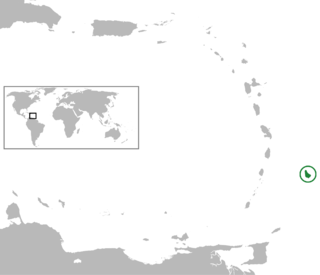
Barbados is an island country in the Lesser Antilles of the West Indies, in the Caribbean region next to North America and north of South America, and is the most easterly of the Caribbean islands. It lies on the boundary of the South American and Caribbean plates. Its capital and largest city is Bridgetown.

Bridgetown is the capital and largest city of Barbados. Formerly The Town of Saint Michael, the Greater Bridgetown area is located within the parish of Saint Michael. Bridgetown is sometimes locally referred to as "The City", but the most common reference is simply "Town". As of 2014, its metropolitan population stands at roughly 110,000.

Barbados is a continental island in the North Atlantic Ocean and is located at 13°10' north of the equator, and 59°32' west of the Prime Meridian. As the easternmost isle of the Lesser Antilles in the West Indies, Barbados lies 160 kilometres (100 mi) east of the Windward Islands and Caribbean Sea. The maritime claim for Barbados is a territorial sea of 12 nmi, with an exclusive economic zone of 200 nmi which gives Barbados a total maritime area of 186,898 km2 (72,162 sq mi). Of the total EEZ area, 70,000 km2 is set aside for offshore oil exploration. A pending application to UNCLOS has placed for consideration a continental shelf 200 nmi to the east and south. To the west, most of Barbados' maritime boundaries consist of median lines with neighbours. These neighbours include: Martinique, and Saint Lucia to the northwest, Saint Vincent and the Grenadines to the west, Trinidad and Tobago and Venezuela to the southwest, and Guyana to the southeast.

The Lesser Antilles are a group of islands in the Caribbean Sea, forming part of the Caribbean islands or West Indies. They are distinguished from the larger islands of the Greater Antilles to the west. They form an arc which begins east of Puerto Rico at the archipelago of the Virgin Islands, swings southeast through the Leeward and Windward Islands towards South America, and turns westward through the Leeward Antilles along the Venezuelan coast.

Mount Robson Provincial Park is a provincial park in the Canadian Rockies with an area of 2,249 km2. The park is located entirely within British Columbia, bordering Jasper National Park in Alberta. The B.C. legislature created the park in 1913, the same year as the first ascent of Mount Robson by a party led by Conrad Kain. It is the second oldest park in the provincial system. The park is named for Mount Robson, which has the highest point in the Canadian Rockies and is located entirely within the park.
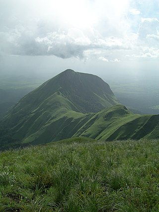
Mount Nimba is a mountain along the border of Guinea, Ivory Coast and Liberia in West Africa. The summit is on the border of Guinea and Ivory Coast and at 1,752 m (5,748 ft) is the highest peak for both countries and of the Nimba Range. The mountain is part of the Guinea Highlands, which straddles the borders between the three countries. The nearest major settlements are the town Yekepa in Liberia and the towns of Bossou and N'Zoo in Guinea.

Saint Andrew is one of eleven parishes of Barbados. It is situated in the northeastern area in the country.

Dame Ruth Nita Barrow, GCMG DA was the first female governor-general of Barbados. Barrow was a nurse and a public health servant from Barbados. She served as the fifth governor-general of Barbados from 6 June 1990 until her death on 19 December 1995. She was the older sister of Errol Barrow, the first prime minister of Barbados.
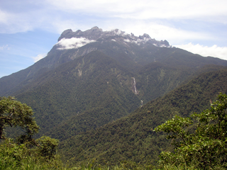
Kinabalu Park, established as one of the first national parks of Malaysia in 1964, is Malaysia's first World Heritage Site designated by UNESCO in December 2000 for its "outstanding universal values" and the role as one of the most important biological sites in the world with more than 4,500 species of flora and fauna, including 326 bird and around 100 mammal species, and over 110 land snail species.
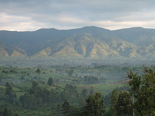
Rwenzori Mountains National Park is a Ugandan national park and UNESCO World Heritage Site located in the Rwenzori Mountains. Almost 1,000 km2 (386 sq mi) in size, the park has Africa's third highest mountain peak and many waterfalls, lakes, and glaciers. The park is known for its beautiful plant life.
The following is an alphabetical list of topics related to the nation of Barbados.
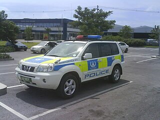
The Barbados Police Service (BPS), previously called the Royal Barbados Police Force (RBPF), is the law enforcement agency in Barbados, as established under the Police Act, Cap. 167. Richard Boyce is currently Commissioner of the Police.
The following outline is provided as an overview of and introduction to Barbados:
The industrial heritage of Barbados, an island nation in the Caribbean, is exemplified by a number of specific structures still standing.
Freemasonry in Barbados is one of the oldest established organisations in the country. Regular Freemasonry is controlled from London and Edinburgh by the United Grand Lodge of England (UGLE) and the Grand Lodge of Scotland through local Provincial Grand Lodges. More recently Prince Hall Freemasonry has also been established on the island.
