Choluteca Department

Last updated

Choluteca Department
Departamento de Choluteca
Choluteca in Honduras.svg
Location of Choluteca in Honduras
Country Honduras
Municipalities 16
Villages198
FoundedJune 28, 1825 [lower-alpha 1]
Capital city Choluteca
Government
  GobernadorEdgardo Tato Loucel (2018–2022) (PNH)
Area
  Total4,397 km2 (1,698 sq mi)
Population
 (2015)
  Total447,852
  Density100/km2 (260/sq mi)
GDP (Nominal, 2015 US dollar)
  Total$1.0 billion (2023) [1]
  Per capita$1,800 (2023)
GDP (PPP, 2015 int. dollar)
  Total$2.0 billion (2023)
  Per capita$3,800 (2023)
Time zone UTC+6 (CDT)
Postal code
51101, 51201
ISO 3166 code HN-CH
HDI (2021)0.583 [2]
medium · 13th of 18
Statistics derived from Consult INE online database: Population and Housing Census 2013 [3]

Choluteca is one of the 18 departments (departamentos) into which Honduras is divided. The departmental capital is the city of Choluteca. The Choluteca River runs through the department.

Contents

History

In the mesoamerican classical period  [ es ], the indigenous Cholutecas were engaged in trade in a vast territory encompassing the south of Mexico, Belize, Guatemala, parts of El Salvador and Nicaragua. In the exercise of this industry they reached the South Coast of Honduras, and founded the settlement of what is now the city of Choluteca hundreds of years before the Spanish conquest.

Choluteca was created as a division of colonial rule from Guatemala in March 1535. Upon independence from Spain, the department of Choluteca was created on June 28, 1825, as one of the seven original departments in which Honduras was divided after independence during the government of the first head of state of Honduras, Dionisio de Herrera. Its borders were changed twice after the original partition. In 1843 the district of Guascorán was added to its territory, until then part of Comayagua. In 1893 its westernmost part was split, with the creation of the Valle department.[ citation needed ]

Geography

Choluteca is the southernmost department of Honduras with an area of 4360 km2. In 2015 it had an estimated population of 447,852 inhabitants. [3] Chuleteca has many lands that are used for agriculture, fishing, sugar production, and shrimp farms. The head of the department is the city of Choluteca, which is located on the Choluteca river that crosses the department. One crosses the Choluteca Bridge to enter the city.

Choluteca is bordered to the north by the departments of Francisco Morazán and El Paraíso, to the west by the Golfo de Fonseca and the department of Valle, and to the east and south by Nicaragua.

Governance

Municipalities

Rural Choluteca Department. Rural Choluteca.jpg
Rural Choluteca Department.
  1. Apacilagua
  2. Choluteca
  3. Concepción de María
  4. Duyure
  5. El Corpus
  6. El Triunfo
  7. Marcovia
  8. Morolica
  9. Namasigue
  10. Orocuina
  11. Pespire
  12. San Antonio de Flores
  13. San Isidro
  14. San José
  15. San Marcos de Colón
  16. Santa Ana de Yusguare

Deputies

The Choluteca Department has a number of 9 deputies elected for the National Congress.

National Congress Deputies 2018–2022
DeputyDepartmentParty
Mauricio Oliva Choluteca PNH
Carlos LedezmaCholuteca PNH
Clara LaínezCholuteca PNH
Selvin RuedaCholuteca PNH
María BardalesCholuteca PNH
Yuri SabasCholuteca PLH
Carlos LaraCholuteca PLH
Luis MartínezCholuteca Libre
David ReyesCholuteca PINU-SD

Economy

The department is, historically, a prominent producer of gold, silver, and copper. The region also had a cattle industry. [4]

Related Research Articles

<span class="mw-page-title-main">Francisco Morazán Department</span> Department in Honduras

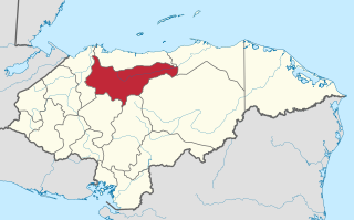
Francisco Morazán is one of the departments of Honduras.

<span class="mw-page-title-main">Copán Department</span> Department in Honduras

Copán is one of the departments in the western part of Honduras. The departmental capital is the town of Santa Rosa de Copán. The department is well known for its tobacco and fine cigars.

<span class="mw-page-title-main">Intibucá Department</span> Department in Honduras

Intibucá is one of the 18 departments in the Republic of Honduras. Intibucá covers a total surface area of 1,186.1 square miles (3,072 km2). Its capital is the city of La Esperanza, in the municipality of La Esperanza.

<span class="mw-page-title-main">Comayagua Department</span> Department in Honduras

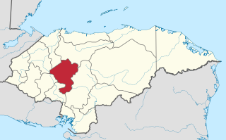
Comayagua is one of the 18 departments (departamentos) into which Honduras is divided. The departmental capital is Comayagua.

<span class="mw-page-title-main">El Paraíso Department</span> Department in Honduras

El Paraíso is one of the 18 departments (departamentos) into which Honduras is divided.

<span class="mw-page-title-main">Gracias a Dios Department</span> Department in Honduras

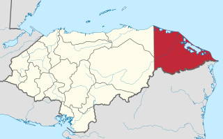
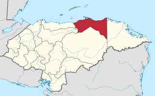
Gracias a Dios is one of the 18 departments (departamentos) into which Honduras is divided. The departmental capital is Puerto Lempira; until 1975 it was Brus Laguna.

<span class="mw-page-title-main">La Paz Department (Honduras)</span> Department in Honduras

La Paz is one of the 18 political and geographic departments of Honduras. The departmental capital is the city of La Paz.

<span class="mw-page-title-main">Lempira Department</span> Department in Honduras

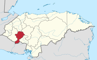
Lempira is one of the 18 departments in Honduras. located in the western part of the country, it is bordered by the departments of Ocotepeque and Copán to the west, Intibucá to the east, and Santa Bárbara to the north. To its south lies the El Salvador–Honduras border. The departmental capital is Gracias.

<span class="mw-page-title-main">Ocotepeque Department</span> Department in Honduras

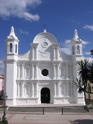
Ocotepeque is one of the 18 departments of Honduras, Central America, located in the West and bordering both El Salvador and Guatemala. It was formed in 1906 from part of Copán department. The capital and main city is Nueva Ocotepeque.

<span class="mw-page-title-main">Santa Bárbara Department, Honduras</span> Department in Honduras

Santa Bárbara is one of the 18 departments (departamentos) into which Honduras is divided. The departmental capital is Santa Bárbara.

<span class="mw-page-title-main">Valle Department</span> Department in Honduras

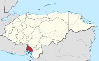
Valle is one of the 18 departments into which Honduras is divided.

<span class="mw-page-title-main">Yoro Department</span> Department in Honduras

Yoro is one of the 18 departments into which Honduras is divided. The department contains rich agricultural lands, concentrated mainly on the valley of the Aguan River and the Sula Valley, on opposite ends. The departmental capital is Yoro. The department covers a total surface area of 7,939 km2 and, in 2005, had an estimated population of 503,886 people. It is famous for the Lluvia de Peces, a tradition by which fish fall from the sky during very heavy rains.

<span class="mw-page-title-main">Choluteca, Choluteca</span> Municipality in Choluteca, Honduras

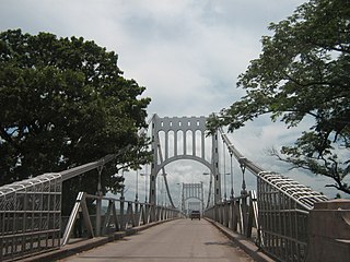
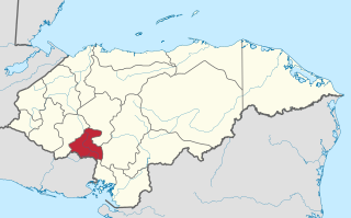
Choluteca is a municipality and the capital city of the Honduran department of the same name. Situated in southern Honduras between El Salvador and Nicaragua, the city is generally considered the regional centre of southern Honduras and is a major transit point on the Pan-American Highway. It has a major bus station and is home to the regional light (ENEE) and water (SANAA) utilities. The city is located on the Choluteca River, near the centre of the department. An arching silver bridge crosses the river into the city.

El Corpus is a municipality in the Honduran department of Choluteca.

<span class="mw-page-title-main">Ocotepeque</span> Municipality in Honduras

Ocotepeque is a municipality in the Honduran department of Ocotepeque. The town of Nueva Ocotepeque is the municipal seat and the capital of the department.

Langue is a municipality in the Valle Department, Honduras.

San Lorenzo is a city, with a population of 35,560, and a municipality in the Honduran department of Valle.

<span class="mw-page-title-main">Dionisio de Herrera</span> First Head of State of Honduras

José Dionisio de la Trinidad de Herrera y Díaz del Valle was a Liberal Honduran politician, head of state of Honduras from 1824 to 1827 and head of state of Nicaragua from 1830 to 1833. During his terms, Honduras and Nicaragua were states within the Federal Republic of Central America. Herrera was an uncle of the Liberal Central American general Francisco Morazán.

The network of highways in Honduras is managed by the Secretariat of public works, transport and housing (SOPTRAVI), through the General Directorate of Roads, which is responsible for planning construction and maintenance work on the country's roads. Honduras has more than 15,400 kilometres (9,600 mi) of roads. Up to 1999, only 3,126 kilometres (1,942 mi) had been paved.

References

  1. "TelluBase—Honduras Fact Sheet (Tellusant Public Service Series)" (PDF). Retrieved January 11, 2024.
  2. "Sub-national HDI – Area Database – Global Data Lab". hdi.globaldatalab.org. Retrieved September 13, 2018.
  3. 1 2 "Consulta Base de datos INE en línea: Censo de Población y Vivienda 2013" [Consult INE online database: Population and Housing Census 2013]. Instituto Nacional de Estadística (INE) (in Spanish). El Instituto Nacional de Estadística (INE). August 1, 2018. Retrieved September 13, 2018.
  4. Baily, John (1850). Central America; Describing Each of the States of Guatemala, Honduras, Salvador, Nicaragua, and Costa Rica. London: Trelawney Saunders. pp. 128–129.

Notes

  1. Choluteca was one of the first 7 departments in which the national territory was divided in the first political division of Honduras in 1825.

13°19′N87°13′W / 13.317°N 87.217°W / 13.317; -87.217