Honduras is divided into 18 departments. Each department is headed by a governor, who is appointed by the President of Honduras. The governor represents the executive branch in the region in addition to acting as intermediary between municipalities and various national authorities; resolves issues arising between municipalities; oversees the penitentiaries and prisons in his department; and regularly works with the various Secretaries of State that form the President's Cabinet. To be eligible for appointment as governor, the individual must a) live for five consecutive years in the department; b) be Honduran; c) be older than 18 years of age and; d) know how to read and write.
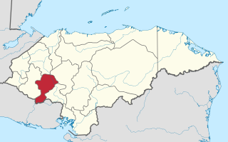
Intibucá is one of the 18 departments in the Republic of Honduras. Intibucá covers a total surface area of 1,186.1 square miles (3,072 km2). Its capital is the city of La Esperanza, in the municipality of La Esperanza.

Choluteca is one of the 18 departments (departamentos) into which Honduras is divided. The departmental capital is city of Choluteca. The Choluteca River runs through the department.

El Paraíso is one of the 18 departments (departamentos) into which Honduras is divided.

La Esperanza is the capital city and a municipality of the same name of the department of Intibucá, Honduras. La Esperanza is famous for having the coolest climate in Honduras. It is considered the heart of the Ruta Lenca, a region of Lenca ethnic influence that spans Honduras from Santa Rosa de Copan to Choluteca. Sites on the Lenca Trail have been designated by the government and United Nations development in order to encourage more cultural tourism, and help create new markets for the traditional crafts, such as pottery, practiced by the Lenca, in order to preserve their culture.
Apacilagua is a small town and municipality in the Honduran department of Choluteca. It is situated 29.3 kilometres (18.2 mi) by road to the northeast of the town of Choluteca, in the northern mid part of the province, not far from the border with the El Paraíso Department. The small town of Apacilagua lies on the Choluteca River along the RN85 road, and contains the Iglesia Catolica Apacilagua, a Catholic church. The municipality covers an area of 213.1 square kilometres (82.3 sq mi), and contains 8 villages and 149 hamlets. As of 2015 it had a population of 9,075 people.
Concepción de María is a municipality in the Honduran department of Choluteca

Duyure is a municipality located in the Honduran department of Choluteca.
Lejamaní is one of the 21 municipalities in the Honduran department of Comayagua.
Pimienta is a town, with a population of 12,990, and a municipality in the Honduran department of Cortés. The name means "pepper" in Spanish.
San Antonio de Cortés is a town, with a population of 5,509, and a municipality in the Honduran department of Cortés.

Valle de Ángeles is a municipality in the Honduran department of Francisco Morazán.
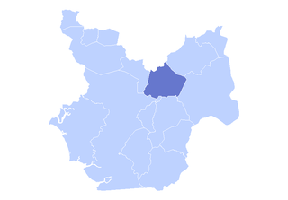
Concepción is a municipality in the Honduran department of Intibucá.
Morazán is a town, with a population of 19,880, and a municipality in the Honduran department of Yoro. This political division of 47,435 people is in the north, located between the city of Yoro and the municipality of El Negrito, north of the Nico Pijol National Park.
San Lorenzo is a city, with a population of 33,810, and a municipality in the Honduran department of Valle.
Honduras is administratively divided into 18 departments which are subdivided into 298 municipalities. Municipalities are the only administrative division in Honduras that possess local government. Each municipality has its own elected mayor as opposed to the appointed governors of departments. For statistical purposes, the municipalities are further subdivided into 3731 aldeas, and those into 27969 caserios. At the lowest level, some caserios are subdivided into 3336 barrios or colonias.

The Choluteca River is a river in southern Honduras. Its source is in the Department of Francisco Morazán, near Lepaterique, and from there it flows north through the city of Tegucigalpa, then south through the department of El Paraíso, and the department and city of Choluteca. The mouth of the river—located among wetland—is near the coastal town of Cedeño, on the Gulf of Fonseca.

The National Autonomous University of Honduras is the national public university of Honduras. Founded in 1847, it has over 140 programs from the Bachelor's level to the Doctorate, and is the largest and highest ranked University in Honduras.

Tegucigalpa, formally Tegucigalpa, Municipality of the Central District, and colloquially referred to as Tegus or Teguz, is the capital and largest city of Honduras along with its twin sister, Comayagüela.

