Duyure

Last updated
Duyure
Duyurearriba.jpg
Photograph of Duyure from above.
Escudo-Duyure.jpg
Nickname: 
Creek of the Coyotes
Honduras location map.svg
Red pog.svg
Duyure
Location in Honduras
Coordinates: 13°38′N86°49′W / 13.633°N 86.817°W / 13.633; -86.817
CountryHonduras
DepartmentCholuteca
MunicipalityDuyure
Government
  MayorCelfida Amada Bustillo Cerna
Population
 (2013)
  Total3,519

Duyure is a municipality located in the Honduran department of Choluteca.

Contents

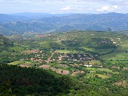
The municipality borders Nicaragua to the east, the department of El Paraíso to the north, the municipality of Morolica to the west, and the municipality of San Marcos de Colón to the south. The Choluteca River runs along the northern and western limits of the municipality. The town center is located 32 kilometers North of the city of San Marcos de Colón via a dirt road connected to the Pan-American Highway.

Located in the center of the municipality is the town center which is surrounded by seven satellite villages and several small housing clusters. The seven satellite villages located outside of the urban center are named: Apasupo, Liraqui, Tierras Coloradas, Carrizal Prieto, El Horno, Alto Pino, and San Lorenzo. Each village contains a public school that educates children ranging from kindergarten to sixth grade. The town center has both a primary school and a high school.

History

Duyure used to be called Valle de la Soledad. In the 1895 Honduran national census it was register as a municipality. [1]

Town center

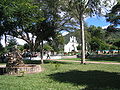
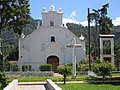
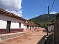
In the center of Duyure stands a large Guanacaste tree which serves as a centerpiece for the town's grassy Central Park. Several large trees, from Acacia to Tamarind, can be found throughout the park. Town Hall faces Central Park from the north side of the park and is located adjacent to the town's only Pool Hall. To the east side of the park stands the Catholic church. The church is rumored to have been constructed during the 19th century, although the interior of the structure underwent renovation in 2008. Neighboring the Catholic church sits the local computer center, formally known as the "Community Center for Knowledge and Communication" (CCCC). Located to the west side of the park is the Health Center (CESAMO) and the town Kindergarten.[ citation needed ]

Transportation

To date, the only available public transportation is a 1.5-hour-long bus ride to San Marcos de Colón. The bus leaves from Duyure for San Marcos de Colón at 6:00 AM and returns to Duyure from San Marcos de Colón at 3:30 PM daily.[ citation needed ]

Demographics

According to the 2013 census, 78% of the population work in agriculture. Fifty-one percent of people uses the public water system and 66% uses the public electricity system. Ninety-five percent uses firewood for cooking and 6% of houses has at least one car. Fifty-seven percent of duyure has a basic education system. [2]

Historical Population
YearPopulation%+%+ Yearly
1887505
190171241.02.9
1905664-6.7-1.7
191083125.25.0
1926767-7.7-0.5
19301,600108.627.2
19351,054-34.1-6.8
1940979-7.1-1.4
19451,22925.55.1
19501,41515.13.0
19611,4452.10.2
19741,68716.71.3
19882,66858.24.2
20012,7533.20.2
20133,51927.82.3
2018 (est.)3,5470.80.2

Geography

Duyure has 5 villages (aldeas) and 57 hamlets. [1] List of villages:

Related Research Articles

<span class="mw-page-title-main">Departments of Honduras</span>

Honduras is divided into 18 departments. Each department is headed by a governor, who is appointed by the President of Honduras. The governor represents the executive branch in the region in addition to acting as intermediary between municipalities and various national authorities; resolves issues arising between municipalities; oversees the penitentiaries and prisons in his department; and regularly works with the various Secretaries of State that form the President's Cabinet. To be eligible for appointment as governor, the individual must a) live for five consecutive years in the department; b) be Honduran; c) be older than 18 years of age and; d) know how to read and write.

<span class="mw-page-title-main">Choluteca Department</span> Department in Honduras

Choluteca is one of the 18 departments (departamentos) into which Honduras is divided. The departmental capital is the city of Choluteca. The Choluteca River runs through the department.

<span class="mw-page-title-main">El Paraíso Department</span> Department in Honduras

El Paraíso is one of the 18 departments (departamentos) into which Honduras is divided.

La Esperanza is the capital city and a municipality of the same name of the department of Intibucá, Honduras. La Esperanza is famous for having the coolest climate in Honduras. It is considered the heart of the Ruta Lenca, a region of Lenca ethnic influence that spans Honduras from Santa Rosa de Copan to Choluteca. Sites on the Lenca Trail have been designated by the government and United Nations development in order to encourage more cultural tourism, and help create new markets for the traditional crafts, such as pottery, practiced by the Lenca, in order to preserve their culture.

<span class="mw-page-title-main">Apacilagua</span> Municipality in Choluteca, Honduras

Apacilagua is a small town and municipality in the Honduran department of Choluteca. It is situated 29.3 kilometres (18.2 mi) by road to the northeast of the town of Choluteca, in the northern mid part of the province, not far from the border with the El Paraíso Department. The small town of Apacilagua lies on the Choluteca River along the RN85 road, and contains the Iglesia Catolica Apacilagua, a Catholic church. The municipality covers an area of 213.1 square kilometres (82.3 sq mi), and contains 8 villages and 149 hamlets. As of 2015 it had a population of 9,075 people.

El Corpus is a municipality in the Honduran department of Choluteca.

Marcovia is a municipality in the Honduran department of Choluteca, on the Gulf of Fonseca.

<span class="mw-page-title-main">San Marcos de Colón</span> Municipality in Choluteca, Honduras

San Marcos de Colón is a town, with a population of 12,870, and a municipality in the Honduran department of Choluteca, located on the border with Nicaragua.

San Agustín is a municipality in the Honduran department of Copán. It is situated 36.4 kilometres (22.6 mi) by road northwest of Santa Rosa de Copán.

Santa Cruz de Yojoa is a town, with a population of 18,780, and a municipality in the Honduran department of Cortés.

Morazán is a town, with a population of 19,880, and a municipality in the Honduran department of Yoro. This political division of 47,435 people is in the north, located between the city of Yoro and the municipality of El Negrito, north of the Nico Pijol National Park.

<span class="mw-page-title-main">La Unión, Olancho</span> Municipality in Olancho, Honduras

La Unión is a municipality in the northwest of the Olancho Department of Honduras.

San Lorenzo is a city, with a population of 33,810, and a municipality in the Honduran department of Valle.

Tlatlaya is one of 125 municipalities of the State of Mexico in Mexico. The municipal seat is the town of Tlatlaya which is the eleventh largest town in the municipality. The word “Tlatlaya” means when the hearth is black and red.

Putla Villa de Guerrero or simply Putla, is a town and municipality in the State of Oaxaca, Mexico. It is part of Putla District in the west of the Sierra Sur Region.

Luvianos is a small town and municipality located in the southwest of the State of Mexico. It gained municipal status in 2000. People can access Luvianos by driving Federal Road 134 south from Toluca, and then take a detour about 25 minutes north of Tejupilco. The name is derived from a hacienda what was established during colonial times.

<span class="mw-page-title-main">San Luis Acatlán (municipality)</span> Municipality in Guerrero, Mexico

San Luis Acatlán is one of the 81 municipalities of Guerrero, in south-western Mexico. The municipal seat lies at San Luis Acatlán. The municipality covers an area of 704.4 km².

<span class="mw-page-title-main">Tegucigalpa</span> Capital and largest city of Honduras

Tegucigalpa, formally Tegucigalpa, Municipality of the Central District, and colloquially referred to as Tegus or Teguz, is the capital and largest city of Honduras along with its sister city, Comayagüela.

The network of highways in Honduras is managed by the Secretariat of public works, transport and housing (SOPTRAVI), through the General Directorate of Roads, which is responsible for planning construction and maintenance work on the country's roads. Honduras has more than 15,400 kilometres (9,600 mi) of roads. Up to 1999, only 3,126 kilometres (1,942 mi) had been paved.

<span class="mw-page-title-main">COVID-19 pandemic in Honduras</span> Ongoing COVID-19 viral pandemic in Honduras

The COVID-19 pandemic in Honduras is part of the worldwide pandemic of coronavirus disease 2019 caused by severe acute respiratory syndrome coronavirus 2. The virus was first confirmed to have spread to Honduras on 10 March 2020, when two women tested positive for the virus after one of them landed on Toncontín International Airport in a flight from Madrid, Spain, and the other on Ramón Villeda Morales International Airport in a flight from Geneva, Switzerland. Confirmed cases have been reported in all 18 departments of the country, with the majority of cases located in Cortés and Francisco Morazán.

References

  1. 1 2 "Duyure, Choluteca – INE". www.ine.gob.hn. Retrieved 2021-04-18.
  2. "CENSO DE POBLACIÓN Y VIVIENDA – INE". www.ine.gob.hn. Retrieved 2021-04-18.

Coordinates: 13°38′N86°49′W / 13.633°N 86.817°W / 13.633; -86.817