Related Research Articles

Central America is a region of the Americas. It is bordered by Mexico to the north, Colombia to the south, the Caribbean Sea to the east, and the Pacific Ocean to the west. Central America consists of seven countries: Belize, Costa Rica, El Salvador, Guatemala, Honduras, Nicaragua, and Panama. Their combined population is estimated at 44.53 million (2016).

Honduras is a country in Central America. Honduras borders the Caribbean Sea and the North Pacific Ocean. Guatemala lies to the west, Nicaragua south east and El Salvador to the south west. Honduras is the second largest Central American republic, with a total area of 112,890 square kilometres (43,590 sq mi).
La Mosquitia is the easternmost part of Honduras along the Mosquito Coast, which extends into northeastern Nicaragua. It is a region of tropical rainforest, pine savannah, and marsh that is accessible primarily by water and air. Its population includes indigenous and ethnic groups such as the Miskito, Pech, Rama, Sumo, Garífuna, Ladino, and Creole peoples. La Mosquitia has the largest wilderness area in Central America, consisting of mangrove swamps, lagoons, rivers, savannas, and tropical rain forests. The Río Plátano Biosphere Reserve, a World Heritage site, is a part of La Mosquitia.

The Río Plátano Biosphere Reserve is 5,250 km2 of preserved land in the La Mosquitia region on the Caribbean coast of Honduras. Most of the land runs along the Río Plátano. The reserve has a number of endangered species and some of Honduras largest sections of forest. It has been a World Heritage site and biosphere reserve since 1982. In 2011, UNESCO placed the reserve on the List of World Heritage in Danger.
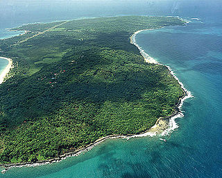
The Mosquitia-Nicaraguan Caribbean Coast mangroves ecoregion, in the Mangrove biome, are along the Caribbean coasts of Nicaragua, Honduras, and Costa Rica as well as off shore islands such as the Corn Islands.
The Central America bioregion is a biogeographic region comprising southern Mexico and Central America.

This is an Index of Central America-related articles. This index defines Central America as the seven nations of Belize, Costa Rica, El Salvador, Guatemala, Honduras, Nicaragua, and Panama.

The Isthmian–Atlantic moist forests (NT0129) are a Central American tropical moist broadleaf forest ecoregion located on the lowland slopes on the caribbean sea side of Nicaragua and Costa Rica and the Gulf and Pacific Ocean sides of Panama. The forest species are a mix of North American and South American, as this region only became a land bridge in the past 3 million years.

The Central American montane forests are an ecoregion of the tropical and subtropical moist broadleaf forests biome, as defined by the World Wildlife Fund, located in mountains of Central America.

The Central American dry forests ecoregion, of the tropical and subtropical dry broadleaf forests biome, is located in Central America.

The Miskito pine forests ecoregion covers lowland pine forests and savanna along much of the Mosquito Coast in northeastern Nicaragua and southeastern Honduras. Pines are adapted to grow in the poor soil, relative to the surrounding moist forest, and repeated burning have left one species – the Caribbean pine – dominant. Although the ecoregion receives high levels of rain, the hard soils, repeated burning, and exposure to hurricanes have left expanses of 'pine savanna' and seasonal wetlands. The area is thinly settled by humans and there is little crop agriculture.

The Mesoamerican Gulf-Caribbean mangroves ecoregion covers the series of disconnected mangrove habitats along the eastern coast of Central America. These salt-water wetlands are found in river deltas, lagoons, and low-lying areas facing the Gulf of Mexico and Caribbean Sea, from Tampico, Mexico to central Panama. The mangroves are areas of high biodiversity and endemism. Many of the sites are protected as national parks or nature reserves.
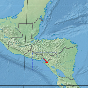
The Gulf of Fonseca mangroves ecoregion covers the brackish mangrove forests around the Gulf of Fonseca on the Pacific Ocean. The Gulf is the meeting point El Salvador, Honduras, and Nicaragua. The Gulf is one of the two primary nesting sites of the critically endangered Hawksbill turtle in the eastern Pacific. In the Honduras portion, there are seven nature reserves that collectively make up a RAMSAR wetland of international importance, providing protection for migratory birds, sea turtle, and fish.
References
- ↑ "Central American Atlantic moist forests". World Wildlife Fund. Retrieved 2013-09-24.
- ↑ "Central American montane forests". World Wildlife Fund. Retrieved 2013-09-24.
- ↑ "Central American dry forests". World Wildlife Fund. Retrieved 2013-09-24.
- ↑ "Central American pine-oak forests". World Wildlife Fund. Retrieved 2013-09-24.
- ↑ "Miskito pine forests". World Wildlife Fund. Retrieved 2013-09-24.
- ↑ "Gulf of Fonseca mangroves". World Wildlife Fund. Retrieved 2013-09-24.
- ↑ "Mosquitia-Nicaraguan Caribbean Coast mangroves". World Wildlife Fund. Retrieved 2013-09-23.
- ↑ "Northern Honduras mangroves". World Wildlife Fund. Retrieved 2013-09-24.
- ↑ "Chiapas - Fonseca". Freshwater Ecoregions of the World. Archived from the original on 2013-09-24. Retrieved 2013-09-24.
- ↑ "Quintana Roo - Motagua". Freshwater Ecoregions of the World. Retrieved 2013-09-24.[ permanent dead link ]
- ↑ "Mosquitia". Freshwater Ecoregions of the World. Retrieved 2013-09-24.[ permanent dead link ]
- ↑ "Estero Real - Tempisque". Freshwater Ecoregions of the World. Archived from the original on 2012-06-02. Retrieved 2013-09-24.
- 1 2 3 "Marine Ecoregions (Spalding 2007). [Map by] GEOMAR, University of Seville, Department of Human Geography". Marine ecoregions. marineplan.es. Archived from the original (JPG) on 2017-02-12. Retrieved 2013-09-26.
- ↑ "Mesoamerican Reef". World Wildlife Fund. Retrieved 2013-08-19.

!["Marine Ecoregions (Spalding 2007). [Map by] GEOMAR, University of Seville, Department of Human Geography"](https://web.archive.org/web/20170212110426/http://www.marineplan.es/ES/fichas_kml/mapasfichas/ecoregions.jpg)