This is a list of active and extinct volcanoes in Honduras.
| Name | Elevation | Location | Last eruption | |
|---|---|---|---|---|
| meters | feet | Coordinates | ||
| Isla el Tigre | 783 | 2569 | 13°13′37″N87°38′28″W / 13.227°N 87.641°W | Holocene |
| Isla Zacate Grande | 640 | 2100 | 13°20′N87°50′W / 13.33°N 87.83°W | Holocene |
| Lake Yojoa | 1090 | 3576 | 14°59′N87°59′W / 14.98°N 87.98°W | Holocene |
| Utila Island | 74 | 243 | 16°06′N86°54′W / 16.10°N 86.90°W | Holocene |

Central America is a region of the Americas. It is bordered by Mexico to the north, Colombia to the south, the Caribbean Sea to the east, and the Pacific Ocean to the west. Central America consists of seven countries: Belize, Costa Rica, El Salvador, Guatemala, Honduras, Nicaragua, and Panama. Their combined population is estimated at 44.53 million (2016).
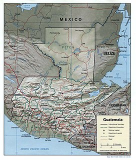
Guatemala is mountainous, except for the south coastal area and the vast northern lowlands of Petén department. The country is located in Central America, bordering the Caribbean Sea, between Honduras and Belize and bordering the North Pacific Ocean, between El Salvador and Mexico. Two mountain chains enter Guatemala from west to east, dividing the country into three major regions: the highlands, where the mountains are located; the Pacific coast, south of the mountains; and the limestone plateau of the Petén region, north of the mountains. These areas vary in climate, elevation, and landscape, providing dramatic contrasts between hot and humid tropical lowlands and highland peaks and valleys.
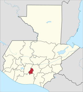
Sacatepéquez is one of the 22 departments of Guatemala. The name comes from Sacatepéquez, a city from November 21, 1542 until July 29, 1773 when it was destroyed by the 1773 Guatemalan Earthquake. Sacatepéquez means grasshill in the Nahuatl language. The capital of Sacatepéquez is Antigua Guatemala which is home to an extensive textile marketplace. Other important cities include Ciudad Vieja and San Lucas Sacatepéquez, which also hosts a marketplace and is a culinary attraction. The Chajoma were a group of indigenous people who were Kaqchikel speaking Indians identified Mixco Viejo as their capital, and spread throughout the Sacatepequez Department until their capital was moved to Ciudad Vieja, in Antigua.

These lists cover volcanoes by type and by location.

Masaya is a caldera located in Masaya, Nicaragua, 20 km south of the capital Managua. It is Nicaragua's first and largest national park, and one of 78 protected areas of Nicaragua. The complex volcano is composed of a nested set of calderas and craters, the largest of which is Las Sierras shield volcano and caldera. Within this caldera lies a sub-vent, which is Masaya Volcano sensu stricto. The vent is a shield type composing of basaltic lavas and tephras and includes a summit crater. This hosts Masaya caldera, formed 2,500 years ago by an 8-km³ basaltic ignimbrite eruption. Inside this caldera a new basaltic complex has grown from eruptions mainly on a semi-circular set of vents that include the Masaya and Nindiri cones. The latter host the pit craters of Masaya, Santiago, Nindiri and San Pedro. Observations in the walls of the pit craters indicate that there have been several episodes of cone and pit crater formation.

Utila(Isla de Utila) is the smallest of Honduras' major Bay Islands, after Roatán and Guanaja, in a region that marks the south end of the Mesoamerican Barrier Reef System, the second-largest in the world.

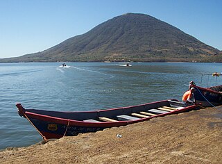
Lake Yojoa is the largest lake in Honduras with a surface area of 79 square kilometers (30.50 mi²) and an average depth of 15 meters (50 ft). At an altitude of 700 meters (2,300 ft), it lies in a depression formed by volcanoes. The Lake Yojoa volcanic field consists of Pleistocene to Holocene scoria cones, craters, and lava flows.
El Tigre is an island located in the Gulf of Fonseca, a body of water on the Pacific coast of Central America. The island is a conical basaltic stratovolcano and the southernmost volcano in Honduras. It belongs to Valle department. Together with Isla Zacate Grande, Isla Comandante and a few tiny satellite islets and rocks, it forms the municipality of Amapala, with an area of 75.2 km2 (29.0 sq mi) and a population of 9,687 as of the census of 2001.

Zapatera is a shield volcano located in the southern part of Nicaragua. It forms the island of Isla Zapatera in the Lake Nicaragua. Isla Zapatera constitutes one of 78 protected areas of Nicaragua.

The Sierra Madre de Chiapas is a major mountain range in Central America. It crosses El Salvador, Guatemala, Mexico and Honduras. The Sierra Madre de Chiapas is part of the American Cordillera, a chain of mountain ranges that consists of an almost continuous sequence of mountain ranges that form the western "backbone" of North America, Central America, and South America.
The coat of arms of Honduras is a national emblem of the Republic of Honduras.

The following outline is provided as an overview of and topical guide to Honduras:

This is an Index of Central America-related articles. This index defines Central America as the seven nations of Belize, Costa Rica, El Salvador, Guatemala, Honduras, Nicaragua, and Panama.

El Salvador became independent from Spain in 1821. It has produced its own stamps since 1867.
