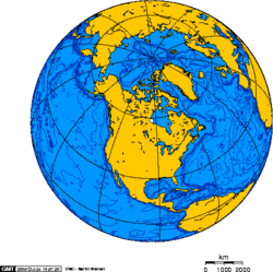
The northern half of North America is sparsely populated and covered mostly by Canada, except for the northeastern portion, which is occupied by Greenland, and the northwestern portion, which is occupied by Alaska, the largest state of the United States. The central and southern portions of the continent are occupied by the contiguous United States, Mexico, and numerous smaller states in Central America and in the Caribbean.
The continent is delimited on the southeast by most geographers at the Darién watershed along the Colombia-Panama border, placing all of Panama within North America.[2][3][4] Alternatively, a less common view would end North America at the man-made Panama Canal. Islands generally associated with North America include Greenland, the world's largest island, and archipelagos and islands in the Caribbean. The terminology of the Americas is complex, but "Anglo-America" can describe Canada and the U.S., while "Latin America" comprises Mexico and the countries of Central America and the Caribbean, as well as the entire continent of South America.
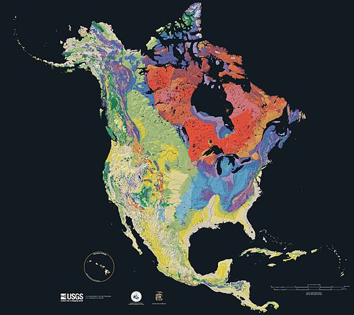
The paleogeological origins of the basement rocks underlying North America.Age of the bedrock underlying North America, from red (oldest) to blue, green, yellow (newest).
Seventy percent of North America is underlain by the Laurentia craton,[5] which is exposed as the Canadian Shield in much of central and eastern Canada around the Hudson Bay, and as far south as the U.S. states of Michigan, Wisconsin, and Minnesota. The continental crust started to form 4 billion years ago (Ga), and six of the microcontinents collided to form the craton about 2 Ga. This core has been enlarged by plate tectonics, most notably between 1.8 and 1.65 Ga when a piece currently stretching from Arizona to Missouri fused with the south and west portion of the craton. The craton started to rift about 1.1 Ga, and the fissure (now the Midcontinent Rift System) ran between Kansas and Lake Superior before stopping, perhaps due to the Grenville collision in the east. Otherwise the craton has remained relatively stable, with some rocks dating from 2.5 to 4 Ga, including what may be the world's oldest known rock: Specimens from the Nuvvuagittuq greenstone belt on the coast of the Hudson Bay have been dated to 4.38 Ga,[6][7] though the dating methods are disputed.[8] Periodic flooding by inland seas, most recently the Western Interior Seaway during the Cretaceous, caused the layer of sedimentary rock over the remainder of the craton. The Laurentia craton is the center of the Proterozoic supercontinent Rodinia in most models,[9] and was also part of the later Laurussia, Pangea, and Laurasia supercontinents.
The plain is a belt of lowlands widening to the south that extends from south New England to Mexico.
Interior Lowlands
The lowlands extend down the middle of the continent from the Mackenzie Valley to the Atlantic Coastal Plain, and include the Great Plains on the west and the agriculturally productive Interior Plains on the east.
The cordillera is a complex belt of mountains and associated plateaus and basins some of which were formed as recently as 100–65 Ma, during the Cretaceous. The cordillera extend from Alaska into Mexico and includes two orogenic belts — the Pacific Margin on the west and the Rocky Mountains on the east — separated by a system of intermontane plateaus and basins.[10]
The Coastal Plain and the main belts of the North American Cordillera continue in the south in Mexico (where the Mexican Plateau, bordered by the Sierra Madre Oriental and the Sierra Madre Occidental, is considered a continuation of the intermontane system) to connect the Transverse Volcanic Range, a zone of high and active volcanic peaks south of Mexico City.
The vast majority of North America is located on the North American Plate, centered on the Laurentia craton. Parts of California and western Mexico form the partial edge of the Pacific Plate; the two plates meet along the San Andreas Fault. The southern portion of the Caribbean and parts of Central America compose the much smaller Caribbean Plate.
The western mountains have split in the middle, into the main range of the Rockies and the Coast Ranges in California, Oregon, Washington, and British Columbia with the Great Basin (a lower area containing smaller ranges and low-lying deserts) in between. The highest peak is Denali (also called Mount McKinley) in Alaska.
Three countries (Canada, the United States, and Mexico) make up most of North America's land mass; they share the continent with 34 other island countries in the Caribbean and south of Mexico.
Geographic center of North America
The geographic center of North America is near Center, North Dakota,[14] according to Peter Rogerson, geography professor at the University at Buffalo, who published a new method of calculating geographical centers.[15]
The Great Plains is the broad expanse of prairie and steppe which lies east of the Rocky Mountains in the United States and Canada. The narrow plains in the Mexican coast and the savannas of the Mississippi are analogous to, respectively, the Patagonian Steppes and the pampas of the Piranha, Paraguay, and Rio de la Plata. Thus the Appalachians and the mountain chains of Brazil are regarded as creating similar interruptions to the plains community.[20]
North America extends to within 10° of latitude of both the equator and the North Pole. It embraces every climatic zone, from tropical rain forest and savanna on the lowlands of Central America to areas of permanent ice cap in central Greenland.[20]Subarctic and tundra climates prevail in north Canada and north Alaska, and desert and semiarid conditions are found in interior regions cut off by high mountains from rain-bearing westerly winds.[12] However, most of the continent has temperate climates very favorable to settlement and agriculture. Prairies, or vast grasslands cover a huge amount in mountain ranges.[12]
The average rainfall in North America is 76cm/year, which produces some 18 petaliters of water.[22]
River systems
North American Watersheds (Atlantic, Arctic, Great Basin, & Pacific)Saint Lawrence River on the New York–Ontario borderThe Upper Rio Grande by Creede, ColoradoThe Columbia River from Canada to the Pacific
Listed below by watershed are some of the more notable rivers in North America. Rivers flow entirely within the United States, unless otherwise noted.[23]
North America map of Köppen climate classification.
Climate and vegetation
There are various plant life distributions in North America. Plant life in the Arctic includes grasses, mosses, and Arctic willows. Coniferous trees, including spruces, pines, hemlocks, and firs, are indigenous to the Canadian and Western U.S. mountain ranges as far south as San Francisco. Among these are giant sequoias, redwoods, great firs, and sugar pines. Sugar pines are generally confined to the northwestern area of the United States. The central region of the country has hardwoods. Southern states grow extensive yellow pines. In addition, mahogany, logwood, and lignumvitae - all tropical in nature - are grown. The southwest has desert plants, including yucca and cacti. The cultivated native plants of North America are tobacco, maize, vanilla, melons, cacao, gourds, indigo plant, and beans.
Deserts
The Sierra Nevada and Cascade mountain ranges run along the entire Pacific Coast, acting as a barrier to the humid winds that sweep in from the ocean. The rising topography forces this air upwards, causing moisture to condense and fall in the form of rain on the western slopes of the mountains, with some areas receiving more than 70 inches (1.8m) of rainfall per year. As a result, the air has lost much of its moisture and becomes hot and dry when it reaches the areas east of the coastal mountain ranges.[12] These arid conditions are, in some instances, exacerbated in regions of extremely low altitude (some near or below sea level) by higher air pressure, resulting in drier conditions and adiabatic heating effects, some of these pocket deserts exist in valleys well north of the Canada–US border in interior British Columbia. What precipitation does fall generally does not last long, lost primarily to evaporation, as well as rapid runoff and efficient water uptake and storage by native vegetation.
Major habitat types of the United States and Canada
Ecoregions map of Canada, United States and Mexico
Zoology
North America is home to many native mammal species. Several species of deer, including elk, caribou, moose, mule deer, and the abundant white-tailed deer are found throughout various regions, along with the bison in the central plains and the musk ox in the Arctic tundra. Three species of bear, several subspecies of wolf, and various other carnivores such as raccoons, skunks, and cats including cougars and lynxes are widely distributed. The family Mustelidae is well represented, including badgers, otters, ferrets, and wolverines. Numerous species of squirrels and other rodents, such as beavers and muskrats, can be found in virtually every region of the continent. Central America has adapted sloths, anteaters, and armadillos. Other animals includes the California condor, mostly found in California, the parrots and the monkeys of Tropical forests, the humming bird, rattlesnake, alligator, and Cayman of the banks of the streams, and swarms of mosquitoes on the wide plains.
Agriculture and forestry are two major industries. Agriculture includes arid land and irrigated farming and livestock grazing.[1] Livestock are often moved between high-elevation summer pastures and low-elevation and winter pastures.
↑Thomas, William A.; Hatcher, Jr., Robert D. (2021). "Southern-Central Appalachians-Ouachitas Orogen". Encyclopedia of Geology. 4– via Elsevier Science Direct. The foundations of the Appalachian-Ouachita orogen were laid when the assembly of supercontinent Rodinia was completed. The collisional events were accompanied by high-grade metamorphism and magmatism during the Grenville orogeny in the time span of 1300–950 Ma.
↑Rogerson, Peter A. (August 14, 2015). "A New Method for Finding Geographic Centers, with Application to U.S. States". The Professional Geographer. 67 (4): 686–694. doi:10.1080/00330124.2015.1062707.
This page is based on this Wikipedia article Text is available under the CC BY-SA 4.0 license; additional terms may apply. Images, videos and audio are available under their respective licenses.