Continental divide

Last updated
Major continental divides, showing drainage into the major oceans and seas of the world. Grey areas are endorheic basins that do not drain to the ocean. Ocean drainage.png
Major continental divides, showing drainage into the major oceans and seas of the world. Grey areas are endorheic basins that do not drain to the ocean.

A continental divide is a drainage divide on a continent such that the drainage basin on one side of the divide feeds into one ocean or sea, and the basin on the other side either feeds into a different ocean or sea, or else is endorheic, not connected to the open sea. Every continent on earth except Antarctica (which has no known significant, definable free-flowing surface rivers) has at least one continental drainage divide; islands, even small ones like Killiniq Island on the Labrador Sea in Canada, may also host part of a continental divide or have their own island-spanning divide. The endpoints of a continental divide may be coastlines of gulfs, seas or oceans, the boundary of an endorheic basin, or another continental divide. One case, the Great Basin Divide, is a closed loop around an endorheic basin. The endpoints where a continental divide meets the coast are not always definite since the exact border between adjacent bodies of water is usually not clearly defined. The International Hydrographic Organization's publication Limits of Oceans and Seas defines exact boundaries of oceans, but it is not universally recognized. Where a continental divide meets an endorheic basin, such as the Great Divide Basin of Wyoming, the continental divide splits and encircles the basin. Where two divides intersect, they form a triple divide, or a tripoint, a junction where three watersheds meet.

Contents

Whether a divide is considered a continental divide distinguished from other secondary drainage divides may depend on whether the associated gulfs, seas, or oceans are considered separate. For example, the Gulf of Mexico is considered separate from the Atlantic Ocean, so the Eastern Continental Divide separates their respective watersheds. But the Sea of Cortez is usually not considered separate from the Pacific Ocean, so the divide between the Colorado River watershed, which drains to the Sea of Cortez, and the Columbia River watershed, which drains to the Pacific Ocean, is not considered to be a continental divide.

Together, continental divides demarcate a set of drainage basins or watersheds, each of which drains to a specific ocean, sea or gulf, such as the North American Atlantic seaboard watershed which is demarcated by the Eastern Continental Divide and Great Lakes-St. Lawrence Divide.

Divides by continent

Note: A 'continent' for the purpose of water divides may not correspond to a geopolitical or geophysical continent.

Africa

In Africa, the most significant continental divide is the Congo-Nile Divide between the watersheds of the Nile and the Congo, passing through the area of the African Great Lakes. Between the Congo and the Sahara, a vast area drains into the endorheic Lake Chad, puncturing the AtlanticMediterranean divide. The Mediterranean–Indian Ocean divide is punctured in East Africa by the endorheic lake systems of the East African Rift; in the south of the continent the divide between the Atlantic and Indian Oceans snakes between the watersheds of the Congo, Zambezi, Limpopo, and Orange Rivers, with the Okavango terminating in the Kalahari Desert.

Antarctica

Antarctica is not generally considered to have a continental divide. The interior of Antarctica receives very little precipitation, and that in the form of snow, and the continent is surrounded by the Southern Ocean. The Transantarctic Mountains divide the ice streams draining West Antarctica into the Ronne Ice Shelf, toward the Pacific Ocean and into the Ross Ice Shelf, from those draining East Antarctica toward the Atlantic and Indian Oceans.

Australia

In Australia, the Great Dividing Range, or Great Divide, largely separates those rivers flowing to the eastern seaboard and the Pacific Ocean from those flowing westward to the Murray–Darling Basin and to the Southern Ocean or to the Gulf of Carpentaria or to the Lake Eyre Basin. Two significant continental drainage divide tripoints are found along the Great Divide. Kennedy Junction [1] marks the hydrological apex of waters running to the Pacific Ocean, via the Fitzroy Basin, the Southern Ocean, via the Murray Darling Basin and the Lake Eyre Basin. Just a little to the north Mitchell Junction marks the hydrological apex of waters running to the Indian Ocean (via the Gulf of Carpentaria and Indonesian Throughflow), the Pacific ocean via the Burdekin Basin and the Lake Eyre Basin. Many of the continents interior rivers drain into the endorheic Lake Eyre Basin, which during previous Ice Ages was a much larger sea.

Eurasia

Eurasia has various divides, depending on the definition of "ocean" (for example, the Mediterranean Sea and its various lobes, the Atlantic Ocean, the Arctic Ocean, the Baltic Sea, the Black Sea, and the North Sea). Examples include:

British Isles

North America

Principal hydrological divides of North America. NorthAmerica-WaterDivides.png
Principal hydrological divides of North America.

If the Gulf of California or Sea of Cortez is considered to be separate from the Pacific Ocean, there is a divide which separates the Pacific Ocean basin from the basin which drains into that gulf/sea, i.e the Colorado River basin:

South America

In South America, the Continental Divide of the Americas lies along the Andes. In Central Chile and nearby areas of Argentina the Principal Cordillera makes up the continental divide. [6] This divide forms much of the Argentina–Chile border. In the Miocene the continental divide in the Principal Cordillera was about 20 km to the west of the modern water divide. [7] Subsequent river incision shifted the divide to the east. [7] Compression and uplift in this part of the Andes has continued into the present. [7]

From Lácar Lake and south there are numerous lakes on the eastern slopes that drain to the Pacific, crossing the line of highest peaks. These lakes in Patagonia are moraine-dammed streams, which used to drain to the Atlantic, rather than the Pacific, before the Pleistocene glaciations.[ citation needed ]

See also

Related Research Articles

<span class="mw-page-title-main">Geography of Canada</span>

Canada has a vast geography that occupies much of the continent of North America, sharing a land border with the contiguous United States to the south and the U.S. state of Alaska to the northwest. Canada stretches from the Atlantic Ocean in the east to the Pacific Ocean in the west; to the north lies the Arctic Ocean. Greenland is to the northeast with a shared border on Hans Island. To the southeast Canada shares a maritime boundary with France's overseas collectivity of Saint Pierre and Miquelon, the last vestige of New France. By total area, Canada is the second-largest country in the world, after Russia. By land area alone, however, Canada ranks fourth, the difference being due to it having the world's largest proportion of fresh water lakes. Of Canada's thirteen provinces and territories, only two are landlocked while the other eleven all directly border one of three oceans.

<span class="mw-page-title-main">Continental Divide of the Americas</span> Principal hydrological divide of North and South America

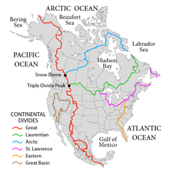
The Continental Divide of the Americas is the principal, and largely mountainous, hydrological divide of the Americas. The Continental Divide extends from the Bering Strait to the Strait of Magellan, and separates the watersheds that drain into the Pacific Ocean from those river systems that drain into the Atlantic and Arctic Ocean, including those that drain into the Gulf of Mexico, the Caribbean Sea, and Hudson Bay.

<span class="mw-page-title-main">Drainage basin</span> Land area where water converges to a common outlet

A drainage basin is an area of land where all flowing surface water converges to a single point, such as a river mouth, or flows into another body of water, such as a lake or ocean. A basin is separated from adjacent basins by a perimeter, the drainage divide, made up of a succession of elevated features, such as ridges and hills. A basin may consist of smaller basins that merge at river confluences, forming a hierarchical pattern.

<span class="mw-page-title-main">Endorheic basin</span> Closed drainage basin that allows no outflow

An endorheic basin is a drainage basin that normally retains water and allows no outflow to other, external bodies of water ; instead, the water drainage flows into permanent and seasonal lakes and swamps that equilibrate through evaporation. Endorheic basins also are called closed basins, terminal basins, and internal drainage systems.

<span class="mw-page-title-main">Eastern Continental Divide</span> Hydrological divide in eastern North America

The Eastern Continental Divide, Eastern Divide or Appalachian Divide is a hydrological divide in eastern North America that separates the easterly Atlantic Seaboard watershed from the westerly Gulf of Mexico watershed. The divide nearly spans the United States from south of Lake Ontario through the Florida peninsula, and consists of raised terrain including the Appalachian Mountains to the north, the southern Piedmont Plateau and lowland ridges in the Atlantic Coastal Plain to the south. Water including rainfall and snowfall, lakes, streams and rivers on the eastern/southern side of the divide drains to the Atlantic Ocean; water on the western/northern side of the divide drains to the Gulf of Mexico. The ECD is one of six continental hydrological divides of North America which define several drainage basins, each of which drains to a particular body of water.

<span class="mw-page-title-main">Great Divide Basin</span> Endorheic basin adjoining the Continental Divide in southern Wyoming, USA

The Great Divide Basin or Great Divide Closed Basin is an area of land in the Red Desert of Wyoming where none of the water falling as rain to the ground drains into any ocean, directly or indirectly. It is thus an endorheic basin, one of several in North America that adjoin the Continental Divide. To the south and west of the basin is the Green River watershed, draining to the Gulf of California/Pacific Ocean; to the north and east is the North Platte watershed, draining to the Gulf of Mexico. The basin is very roughly rectangular in shape; the northwest corner is at Oregon Buttes near South Pass, about 40 miles (64 km) southwest of Lander, and the southeast corner is in the Sierra Madre Range near Bridger Pass, about 20 miles (32 km) southwest of Rawlins.

<span class="mw-page-title-main">Triple Divide Peak (Montana)</span> Mountain in Montana, United States. Located at the hydrological apex of North America.

Triple Divide Peak is located in the Lewis Range, part of the Rocky Mountains in North America. The peak is a feature of Glacier National Park in the state of Montana in the United States. The summit of the peak, the hydrological apex of the North American continent, is the point where two of the principal continental divides in North America converge, the Continental Divide of the Americas and the Northern or Laurentian Divide.

<span class="mw-page-title-main">Drainage divide</span> Elevated terrain that separates neighbouring drainage basins

A drainage divide, water divide, ridgeline, watershed, water parting or height of land is elevated terrain that separates neighboring drainage basins. On rugged land, the divide lies along topographical ridges, and may be in the form of a single range of hills or mountains, known as a dividing range. On flat terrain, especially where the ground is marshy, the divide may be difficult to discern.

<span class="mw-page-title-main">European watershed</span>

The main European watershed is the drainage divide ("watershed") which separates the basins of the rivers that empty into the Atlantic Ocean, the North Sea and the Baltic Sea from those that feed the Mediterranean Sea, the Adriatic Sea and the Black Sea. It stretches from the tip of the Iberian Peninsula at Gibraltar in the southwest to the endorheic basin of the Caspian Sea in Russia in the northeast.

<span class="mw-page-title-main">Geography of North America</span> Overview of the geography of North America

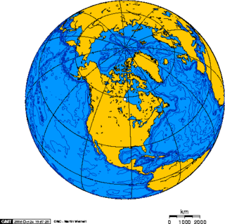
North America is the third largest continent, and is also a portion of the third largest supercontinent if North and South America are combined into the Americas and Africa, Europe, and Asia are considered to be part of one supercontinent called Afro-Eurasia. With an estimated population of 580 million and an area of 24,709,000 km2 (9,540,000 mi2), the northernmost of the two continents of the Western Hemisphere is bounded by the Pacific Ocean on the west; the Atlantic Ocean on the east; the Caribbean Sea on the south; and the Arctic Ocean on the north.

<span class="mw-page-title-main">Laurentian Divide</span> Hydrological divide in North America

The Laurentian Divide also called the Northern Divide and locally the height of land, is a continental divide in central North America that separates the Hudson Bay watershed to the north from the Gulf of Mexico watershed to the south and the Great Lakes-St. Lawrence watershed to the southeast.

A continental divide is a drainage divide on a continent such that the drainage basin on one side of the divide feeds into one ocean or sea, and the basin on the other side either feeds into a different ocean or sea, or is unconnected. Continental divide may also refer to:

<span class="mw-page-title-main">Lake bifurcation</span> Lake that flows into two drainage basins

A lake bifurcation occurs when a lake has outflows into two different drainage basins. In this case, the drainage divide cannot be defined exactly, as it is situated in the middle of the lake.

<span class="mw-page-title-main">Great Basin Divide</span> Hydrological divide in western United States bounding a large endorheic basin

The Great Basin Divide in the western United States is the ridgeline that separates the Great Basin from the Pacific Ocean watershed, which completely surrounds it.

<span class="mw-page-title-main">Watersheds of North America</span>

Watersheds of North America are large drainage basins which drain to separate oceans, seas, gulfs, or endorheic basins. There are six generally recognized hydrological continental divides which divide the continent into seven principal drainage basins spanning three oceans and one endorheic basin. The basins are the Atlantic Seaboard basin, the Gulf of Mexico basin, the Great Lakes-St. Lawrence basin, the Pacific basin, the Arctic basin, the Hudson Bay basin, and the Great Basin. Together, the principal basins span the continent with the exception of numerous smaller endorheic basins.

<span class="mw-page-title-main">Triple divide</span> Point where three drainage basins meet

A triple divide or triple watershed is a point on Earth's surface where three drainage basins meet. A triple divide results from the intersection of two drainage divides. Triple divides range from prominent mountain peaks to minor side peaks, down to simple slope changes on a ridge which are otherwise unremarkable. The elevation of a triple divide can be thousands of meters to barely above sea level. Triple divides are a common hydrographic feature of any terrain that has rivers, streams and/or lakes.

<span class="mw-page-title-main">St. Lawrence River Divide</span> Hydrological divide in eastern North America

The Saint Lawrence River Divide is a continental divide in central and eastern North America that separates the Great Lakes-St. Lawrence River Basin from the southerly Atlantic Ocean watersheds. Water, including rainfall and snowfall, lakes, rivers and streams, north and west of the divide, drains into the Gulf of St. Lawrence or the Labrador Sea; water south and east of the divide drains into the Atlantic Ocean or Gulf of Mexico. The divide is one of six continental divides in North America that demarcate several watersheds that flow to different gulfs, seas or oceans.

Wood Mountain Hills are a hilly plateau in the Canadian province of Saskatchewan. The hills are located in the southern part of the province and are part of the Missouri Coteau, which is part of the Laurentian Divide between the watersheds of the Hudson Bay drainage basin of the Arctic Ocean and the Gulf of Mexico of the Atlantic Ocean. The hills are in a semi-arid region known as Palliser's Triangle in the Great Plains ecoregion of North America.

References

  1. "Kennedy Junction". Australian Extremes. March 18, 2021. Retrieved March 18, 2021.
  2. In Europe and internationally, divides are called 'watersheds'.
  3. Latin for "unknown limits"
  4. Foster, John E.; Eccles, W.J. (1985). "Fur Trade". The Canadian Encyclopedia. The Historica Foundation of Canada. Retrieved 2007-12-30.
  5. Gonzalez, Mark (2007). "Continental Divides in North Dakota and North America" (PDF). NDGS Newsletter. North Dakota Geographical Society. Archived from the original (PDF) on 2013-01-17. Retrieved 2009-03-29.
  6. "Orografía de Mendoza". El Portal de Mendoza (in Spanish). Cámara de Turismo de Mendoza and Cooperativa El Portal de Mendoza. Retrieved June 29, 2019.
  7. 1 2 3 Charrier, Reynaldo; Iturrizaga, Lafasam; Charretier, Sebastién; Regard, Vincent (2019). "Geomorphologic and Glacial Evolution of the Cachapoal and southern Maipo catchments in the Andean Principal Cordillera, Central Chile (34°-35º S)". Andean Geology . 46 (2): 240–278. doi: 10.5027/andgeoV46n2-3108 . Retrieved June 9, 2019.