A drainage basin is any area of land where precipitation collects and drains off into a common outlet, such as into a river, bay, or other body of water. The drainage basin includes all the surface water from rain runoff, snowmelt, and nearby streams that run downslope towards the shared outlet, as well as the groundwater underneath the earth's surface. Drainage basins connect into other drainage basins at lower elevations in a hierarchical pattern, with smaller sub-drainage basins, which in turn drain into another common outlet.

The Great Basin is the largest area of contiguous endorheic watersheds in North America. It spans nearly all of Nevada, much of Oregon and Utah, and portions of California, Idaho, and Wyoming. It is noted for both its arid climate and the basin and range topography that varies from the North American low point at Badwater Basin to the highest point of the contiguous United States, less than 100 miles (160 km) away at the summit of Mount Whitney. The region spans several physiographic divisions, biomes, ecoregions, and deserts.

An endorheic basin is a limited drainage basin that normally retains water and allows no outflow to other external bodies of water, such as rivers or oceans, but converges instead into lakes or swamps, permanent or seasonal, that equilibrate through evaporation. Such a basin may also be referred to as a closed or terminal basin or as an internal drainage system or interior drainage basin.
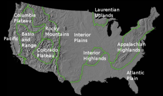
The richly textured landscape of the United States is a product of the dueling forces of plate tectonics, weathering and erosion. Over the 4.5 billion-year history of our Earth, tectonic upheavals and colliding plates have raised great mountain ranges while the forces of erosion and weathering worked to tear them down. Even after many millions of years, records of Earth's great upheavals remain imprinted as textural variations and surface patterns that define distinctive landscapes or provinces.

The Great Divide Basin or Great Divide Closed Basin is an area of land in Wyoming's Red Desert where none of the water falling as rain to the ground drains into any ocean, directly or indirectly. It is therefore considered an endorheic basin, and it adjoins the Continental Divide in southern Wyoming. To the west of the basin is the Green River watershed, draining to the Gulf of California/Pacific Ocean; to the north is the North Platte watershed, draining to the Gulf of Mexico/Atlantic Ocean. The basin is very roughly rectangular in shape; the northwest corner is at Oregon Buttes near South Pass, about 40 miles (64 km) southwest of Lander, and the southeast corner is in the Sierra Madre Range near Bridger Pass, about 20 miles (32 km) southwest of Rawlins.

Triple Divide Peak is located in the Lewis Range, part of the Rocky Mountains in North America. The peak is a feature of Glacier National Park in the state of Montana in the United States. The summit of the peak, the hydrological apex of the North American continent, is the point where two of the principal continental divides in North America converge, the Continental Divide of the Americas and the Northern or Laurentian Divide.

A drainage divide, water divide, divide, ridgeline, watershed, water parting or height of land is elevated terrain that separates neighbouring drainage basins. On rugged land, the divide lies along topographical ridges, and may be in the form of a single range of hills or mountains, known as a dividing range. On flat terrain, especially where the ground is marshy, the divide may be harder to discern.
The Hudson Bay drainage basin is the drainage basin in northern North America where surface water empties into Hudson Bay and adjoining waters. Spanning an area of about 3,861,400 square kilometres (1,490,900 sq mi), the basin is almost totally in Canada, with a small portion in the United States . The watershed's connection to the Labrador Sea is at the Hudson Strait's mouth between Resolution Island in the Qikiqtaaluk Region and Cape Chidley on the Labrador Peninsula. The watershed's headwaters To the southwest are on the Continental Divide of the Americas, bounded at Triple Divide Peak to the south, and Snow Dome to the north. The western and northern boundary of the watershed is the Arctic Divide, and the southern and eastern boundary is the Laurentian Divide.

The Traverse Gap is an ancient river channel occupied by Lake Traverse, Big Stone Lake and the valley connecting them at Browns Valley, Minnesota. It is located on the border of the U.S. states of Minnesota and South Dakota. Traverse Gap has an unusual distinction for a valley: it is crossed by a continental divide, and in some floods water has flowed across that divide from one drainage basin to the other. Before the Anglo-American Convention of 1818 it marked the border between British territory in the north and U.S. – or earlier, French – territory in the south.

The boundaries between the continents of Earth are generally a matter of geographical convention. Several slightly different conventions are in use. The number of continents is most commonly considered seven but may range as low as four when the Americas and Afro-Eurasia are each considered a single continent. According to the definition of a continent in the strict sense, an island cannot be part of any continent, but by convention and in practice most major islands are associated with a continent.
A hydrological code or hydrologic unit code is a sequence of numbers or letters that identify a hydrological feature like a river, river reach, lake, or area like a drainage basin or catchment.
This is a list of articles related to plate tectonics and tectonic plates.
Watersheds of North America are large drainage basins which drain to separate oceans, seas, gulfs, or endorheic basins. There are six generally recognized hydrological continental divides which divide the continent into seven principal drainage basins spanning three oceans and one endorheic basin. The basins are: the Atlantic Seaboard basin, the Gulf of Mexico basin, the Great Lakes-St. Lawrence basin, the Pacific basin, the Arctic basin, the Hudson Bay basin, and the Great Basin. Together, the principal basins span the continent with the exception of numerous smaller endorheic basins.

The American Mediterranean Sea is a name for the combined watershed of the Mississippi River Basin and the waterbody of the Caribbean Sea and the Gulf of Mexico.
The Saint Lawrence River Divide is a continental divide in central and eastern North America that separates the Great Lakes-St. Lawrence River Basin from the southerly Atlantic Ocean watersheds. Water, including rainfall and snowfall, lakes, rivers and streams, north and west of the divide, drains into the Gulf of St. Lawrence or the Labrador Sea; water south and east of the divide drains into the Atlantic Ocean or Gulf of Mexico. The divide is one of six continental divides in North America that demarcate several watersheds that flow to different gulfs, seas or oceans.