Lake Chad (Arabic: بحيرة تشاد, Kanuri: Sádǝ, French: Lac Tchad) is an endorheic freshwater lake located at the junction of four countries: Nigeria, Niger, Chad, and Cameroon, in western and central Africa respectively, with a catchment area in excess of 1,000,000km2 (390,000sqmi). It is an important wetland ecosystem in West-Central Africa. The lakeside is rich in reeds and swamps, and the plain along the lake is fertile, making it an important irrigated agricultural area. The lake is rich in aquatic resources and is one of the important freshwater fish producing areas in Africa.
Lake Chad is divided into deeper southern parts and shallower northern parts. The water source of the lake mainly comes from rivers such as the Chari River that enter the lake. The water level varies greatly seasonally, and the area of the lake also changes dramatically. During the African humid period, the lake's area reached 400,000km2 (150,000sqmi). Due to the increasingly arid climate, the lake surface gradually shrank. In the 19th century, it still had an area of 28,000km2 (11,000sqmi). However, due to climate change and human water diversion, it has shrunk significantly since the mid-1970s, and its area has fluctuated between 2,000 and 5,000km2 (770 and 1,930sqmi).
The Chad Basin was formed by the depression of the African Shield.[6][7][8] The floor of the basin is made of Precambrian bedrock covered by more than 3,600m (11,800ft) of sedimentary deposits.[9] For most of the Quaternary, the basin had abundant water sources. Towards the end of this period the climate became drier. Around 20,000–40,000 years ago, eolianite sand dunes began to form in the north of the basin.[10] The area of Lake Chad experienced four heydays between 39,000 BC and 300 BC, leaving thick diatomaceous earth and lacustrine deposits in the strata. This has been called Mega-Chad. The maximum depth of Mega-Chad exceeds 180m (590ft) and covers an area of approximately 400,000km2 (150,000sqmi),[6] flowed into the Benue River through the Mayo Kébbi, and finally flows into the Atlantic Ocean through the Niger River.[11][12]
The vast waters formed during the African humid period provided conditions for the emergence of lakeside fishermen's settlements, and the Nilo-Saharan ethnic group also migrated to Lake Chad during this period. Agriculture also emerged in the Sahel region at this time.[13] By 1800 BC, a pottery culture known as Gajiganna had emerged, initially as pastoralists, but, starting around 1500 BC, living in settled hamlets at the side of the lake.[14] The archaeological discovery revealed wild grasses, mostly of the tribe Paniceae, and wild rice together with the earliest domesticated Pearl millet in the Lake Chad region, dating to 1200–1000 cal BC. One of the oldest domesticated Pearl millet in West Africa was found in the Chad Basin, charred together with wild grasses, and their era can be traced back to 800–1000 cal BC.[15]
Permanent villages were established to the south of the lake by 500 BC,[16] and major archaeological discoveries include the Sao civilization.[6] According to the records of Claudius Ptolemy in the mid-2nd century AD, the Romans of the 1st century AD had already come into contact with Lake Chad through their connections with Tunisia, Tripolitania, and Fezzan.[17] By the 5th century AD camels were being used for trans-Saharan trade via the Fezzan, or to the east via Darfur.[18] After the Arabs conquered North Africa during the 7th and 8th centuries, the Chad Basin became increasingly linked to the Muslim countries.[16]
Trade and improved agricultural techniques enabled more sophisticated societies.[18] Around 900 AD, the Kanem people who spoke the Kanuri language unified numerous nomadic tribes and established the Kanem Empire in the northeast of Lake Chad. At the beginning of the founding of the country, the Kanem people continued to live a nomadic life until the 11th century, when they were Islamized and settled in Njimi. Through trans-Saharan trade, the power of the Kanem Empire reached its peak in the 13th century, but as the empire declined in the 14th century, its southwestern vassal state of Bornu began to rise, causing the power center of the empire to shift to Bornu around 1400. In the second half of the 16th century, the Bornu Empire began importing firearms from North Africa, consolidating its military hegemony. The Bornu Empire declined in the 18th century, and later lost its western region to the Sokoto Caliphate during the early 19th century. It was later colonised by European powers in the 20th century.[19]
Following the growing interest in Africa among European academic and business communities, the Lake Chad area was extensively described by Europeans in the 19th century. Three scientific expeditions were conducted between 1898 and 1909.[6] During the Berlin Conference in 1884–1885, Africa was divided between the European colonial powers. By the second decade of the 20th century, Lake Chad had been colonized and occupied by Britain, France, and Germany, defining boundaries that are largely intact with the present post-colonial states.[20][21] At the beginning of independence, the countries surrounding Lake Chad not only had a poor economic foundation, but also had more complex ethnic, religious, and political conflicts. Nigeria and Niger, which had just gained independence, experienced continuous coups, while Chad also experienced ongoing civil war. The inability of countries along the lake to consider the protection of Lake Chad has led to a series of environmental problems.[21]
Geography
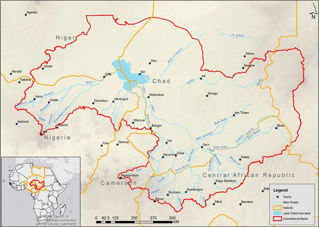
Map showing the Chari River drainage basin
The Chad Basin includes Chad, Nigeria, Cameroon, Niger, Sudan, and the Central African Republic.[22] It is an extensional fault depression type rift basin, which can be divided into four secondary structural units: southern depression, northern depression, central uplift, and eastern slope. The southern depression of the basin is characterized by an asymmetric fault depression composite rift with steep slopes in the east and gentle slopes in the west on the profile, and is distributed in an NNW direction on the plane. There are two large basin‐bounding normal fault developed on both sides of the basin, with a graben style fault and depression in the middle. The east and west sides are outward dipping low angle gentle slope areas. The eastern boundary fault is steep with a dip angle of about 55°, while the western fault has a dip angle of about 45°. The overall thickness of the inner layer in the slope area is relatively thin. In the central area of the basin, the thickness of the sedimentary strata is large, and the thickness of the sedimentary center zone reaches over 10,000m (33,000ft). The northern part of the basin appears steep in the west and gentle in the east on the profile. Five fault structural zones parallel to the basin‐bounding faults have developed from west to east.[23]
Lake Chad is divided into north and south parts by a shallow sill called the Great Barrier, with the bottom of the northern basin at an altitude of 275.3m (903ft) and the bottom of the southern basin at 278.2m (913ft). When the water level in the south exceeds 279m (915ft) above sea level, it will flow into the north.[24] In the south, there is continuous open water at the mouth of the Chari River, and the western part of the water is covered by reed swamps,[25] and the sand dunes that are not completely submerged in the eastern waters form an archipelago.[8] The average depth of the southern lake basin is between .5 and 2m (1ft 8in and 6ft 7in), that of the northern lake basin is between 0 and 1.8m (5ft 11in), and that of the eastern archipelago is between 0 and 2m (6ft 7in).[26]
The climate of the Lake Chad region is strongly influenced by continental and maritime air masses. The maritime air mass moves northward during the summer, producing seasonal precipitation. In late summer, continental air mass dominate again.[6] The average annual precipitation in the Lake Chad area is 330mm (13in), with an average annual precipitation of 560mm (22.0in) on the south bank and about 250mm (9.8in) on the north bank. The highest temperature in the rainy season is 30°C (86°F), and the highest temperature rises to more than 32°C (90°F) when October and November enter the dry season. The temperature difference between day and night is almost twice that of the rainy season, and the lowest nighttime temperature sometimes drops to 8°C (46°F) in December and January. April is usually the hottest month of the year, with temperatures occasionally reaching 40°C (104°F) , the lowest water levels appear in June to July, and the highest water levels in November to December, with surface water temperatures ranging from 19 to 32°C (66 to 90°F) .[6][8]
Hydrology
Shrinking of Lake Chad over the last 7000 years, with the outline of the British Isles for size comparisonLake Chad 1972–2007
The Chad Basin covers an area of about 1×10^6km2 (390,000sqmi), and is injected by the Chari, Logone, and Yobe Rivers.[8][6] The water supply of the lake is seasonal. Most of the precipitation comes from the Adamawa Plateau in the south of the basin, which is transported to the lake basin through the Chari River and the Logone River. The two contribute 95% of the total inflow of Lake Chad, while the Yobe River only contributes less than 2.5%.[7] The lake seeps through the underground to the lowest point of the Chad Basin, the Bodélé Depression, approximately 480km (300mi) northeast of Lake Chad, with the deepest point reaching an elevation of only 155m (509ft) above sea level. This takes away most of the salinity and maintains the low salinity of Lake Chad. The southwestern waters of Lake Chad being freshwater, and the water in the northeast is only slightly salty.[27][7]
The water volume of most large lakes in Africa depends on rainfall and evaporation, which means that temperature and precipitation are crucial for regulating the water balance of these bodies of water, and any fluctuations can cause significant changes in their water level and area.[28] Lake Chad is a shallow inland lake, and the rainfall in the Chad basin is very sensitive to small changes in atmospheric circulation, so the surface area of Lake Chad is greatly affected by climate change.[29][30] Dry climate due to vegetation loss from overgrazing and deforestation and large-scale irrigation projects that diverted water from the rivers that feed the lake are the main reasons for the shrinkage of Lake Chad.[31] The Atlantic multidecadal oscillation and the El Niño–Southern Oscillation have affected precipitation in the Sahel region. From the early 1960s to the mid-1980s, the lake water level decreased by 3m (9.8ft) compared to the average level from 1900 to 2010.[32]
In 1870, the area of Lake Chad was about 28,000km2 (11,000sqmi). The lake was able to flow out of the Bahr el-Ghazal during the rainy season. At the turn of the 20th century the area of Lake Chad shrank briefly, and reached a new high in the middle of the 20th century and overflowed from the Bahr el-Ghazal again.[6] A major drought started in the Sahel region in the late 1960s and caused severe damage in 1972 and 1984. It was thought to be related to vegetation loss, global warming, and sea surface temperature anomalies.[29] During this period, Lake Chad shrunk considerably and fluctuated in the range of 2,000 to 5,000km2 (770 to 1,930sqmi) thereafter.[24]
From June 1966 to January 1973, the area of Lake Chad shrank from 22,772 to 15,400km2 (8,792 to 5,946sqmi),[31] further shrunk to 4,398km2 (1,698sqmi) in 1975,[24] and only 1,756km2 (678sqmi) in February 1994.[31] Since then, the area of Lake Chad has entered a relatively stable stage with a slight increase.[33] From 1995 to 1998, it fluctuated within the range of 1,200 to 4,500km2 (460 to 1,740sqmi). The area once reached 5,075 square kilometres (1,959sqmi) in 2000,[24] and the average area of surface water from 2013 to 2016 was about 1,876km2 (724sqmi), with the largest area being 2,231km2 (861sqmi) in July 2015.[1]
Part of the Chad Basin is located within the Chad Basin National Park in Nigeria, and the country and Cameroon have established the Lake Chad Ramsar Wetland with a total area of 8,225km2 (3,176sqmi).[34]
Plantlife
The wetland plants in the south mainly include cyperus papyrus, etc. Reeds mainly grow in the north where the salinity is high, and the floating plant pistia sometimes covers large areas of open water. Plants such as hyparrhenia rufa grow on the shores of lakes with long floods in the south.[34] The area of permanent vegetation has increased from about 3,800km2 (1,500sqmi) in 2000 to about 5,200km2 (2,000sqmi) in 2020 as water levels have dropped and temperatures have increased.[35] The surrounding dense woodland has been converted to open forest with acacias, baobabs, palms and Indian jujube.[6]
The entire Chad Basin has 179 species of fish, of which 127 are the same as the Niger River Basin, 85 are the same as the Nile River Basin, 47 are the same as the Congo River Basin, and 84 fish species are distributed in the lake.[7] This makes it a rich fishing ground for communities across Nigeria, Niger, Chad, and Cameroon. The seasonal influx of floods combined with seasonal increases in air temperature leads to decreased salinity, increased turbidity, and increased trophic levels, which catalyzed a surge in the number of phytoplankton and zooplankton, allowing large fish to migrate seasonally within the watershed to feed and breed in the fertile floodplain when floods arrive.[25]
Human activities
Lake Chad in a 2001 satellite image. The lake has shrunk by 95% since the 1960s.Building a temporary house in Lake Chad region
There are more than 30 million residents in the Chad Lake Basin. There are more than 70 ethnic groups around the lake, most of whom are distributed on the south bank, where the population density exceeds 100/km2 (260/sqmi). They rely on the water source of Chad Lake for irrigation, breeding, animal husbandry and drinking.[27] Local self-sufficient crops include sorghum, maize, finger millet, beans, and vegetables. Gourd is widely planted for making utensils. The collection of forest products such as gum arabic, honey, beeswax, and firewood is of great significance in the region. However, the reduction in forest area has had a negative impact on the production of these products, and the explosive growth of cattle herds has exacerbated this impact. Cattle are the most important livestock raised, as well as poultry, goats, sheep, camels, horses, and donkeys. The animal husbandry was severely affected by the droughts of the 1970s and 1980s.[6]
Fishing has traditionally been the most important economic activity for the people of the lake area, which almost ceased during drought periods and only resumed in the mid-1990s. Most fishing products are dried, pickled, or smoked. The natron produced in the depression on the northeast bank of the lake has long been of significant economic significance. Traditionally, it has been excavated in blocks and transported across the lake to enter the Nigerian market.[6] Since the drought in the 1970s, the soil that can be planted without irrigation and fertilization has been exposed at the bottom of the lake, and it has been reclaimed as a polder for planting maize, cowpea, rice, sorghum and other crops.[40] Farmers have shifted from planting mainly dry crops, such as wheat, to rice with high water demand, resulting in more serious soil salinization and water eutrophication.[27] The adverse effects of reduced water sources on fishing, farming, and herding outweigh the benefits of new land from the receding waters. The surrounding residents who used to rely on lake water were forced to relocate, causing the economy of the lake area to continuously shrink.[41]
Since 1970, five countries in the southern part of the basin have constructed numerous water conservancy projects in the upper reaches of the Chari River, Logone River, and Yobe River to intercept river water, resulting in a sharp decrease in the amount of water entering the lake. The average annual inflow of the Chari River and the Logone River from 1970 to 1990 was only 55% of that from 1950 to 1970. Since the 1980s, one-third of the water in the Chari River and the Logone River has been diverted and intercepted by the Central African Republic located upstream for agricultural irrigation and hydroelectric power generation.[27] The dams built on the upper reaches of the rivers entering the lake changed the time and scope of seasonal floods and disrupted the migration of fish, resulting in a sharp reduction in the populations of Alestes baremoze and Nile perch, the main catches of Lake Chad, and a significant reduction in the catch.[37][7] At the same time, the conflicts between countries and ethnic groups competing for water and land are also escalating. The four countries along the lake are all facing the problem of extreme poverty, and due to the difficulty in meeting their livelihoods, some local residents have been involved in drug and arms trade.[27] This has been exacerbated by the activity of Boko Haram, an insurgency that has displaced millions of people and disrupted development through the region.[42]
Cameroon, Niger, Nigeria, and Chad established the Lake Chad Basin Commission on 22 May 1964. The Central African Republic joined in 1996, and Libya joined in 2008. The headquarters of the committee is located in N'Djamena, Chad. The commission's tasks include managing Lake Chad and its water resources, protecting the ecosystem, and promoting regional integration, peace, security, and development in the Lake Chad region.[43] The surrounding countries' water replenishment plan for Lake Chad includes the construction of a 2,400km (1,500mi)canal to transport 100×10^9m3 (130×10^9cuyd) of water from the Congo River Basin to the Chari River Basin every year, and use a series of dams along the route to generate electricity.[44]
1 2 3 4 5 6 7 8 9 10 11 12 Gritzner, J. A. "Lake Chad". Encyclopedia Britannica. Chicago: Encyclopædia Britannica, Inc. Archived from the original on 22 July 2019. Retrieved 13 June 2023.
1 2 3 4 Wen Yunzhao. "Lake Chad". Encyclopedia of China (in Chinese (China)) (03ed.). Beijing: Encyclopedia of China Publishing House. Archived from the original on 13 June 2023. Retrieved 11 June 2023.
↑ Mathieu Schuster; Claude Roquin; Philippe Duringer; Michel Brunet; Matthieu Caugy; Michel Fontugne; Hassan Taïsso Mackaye; Patrick Vignaud; Jean-François Ghienne (2005). "Holocene Lake Mega-Chad palaeoshorelines from space". Quaternary Science Reviews. 24 (16–17): 1821–1827. doi:10.1016/j.quascirev.2005.02.001.
↑ Ogundiran, Akinwumi (2005). "Four Millennia of Cultural History in Nigeria (ca. 2000 B.C.–A.D. 1900): Archaeological Perspectives". Journal of World Prehistory. 19 (2): 138. doi:10.1007/s10963-006-9003-y.
↑ Marlies Klee; Barbara Zach (1999). "The Exploitation of Wild and Domesticated Food Plants at Settlement Mounds in North-East Nigeria (1800 cal BC to Today)". The Exploitation of Plant Resources in Ancient Africa: 81–88. doi:10.1007/978-1-4757-6730-8_8. ISBN978-1-4419-3316-4.
1 2 熊正坤; 张瑾 (8 April 2021). "乍得湖:从"文明摇篮"到"死亡之心""[Lake Chad: From "Cradle of Civilization" to "Heart of Death"]. China Water Resources News. Archived from the original on 1 January 2024. Retrieved 1 January 2024.
↑ "about-map". Lake Chad Basin Commission. Retrieved 26 March 2024.
↑ Jacques Lemoalle; Jean-Claude Bader; Marc Leblanc; Ahmed Sedick (January 2012). "Recent changes in Lake Chad: Observations, simulations and management options (1973–2011)". Global and Planetary Change. 80–81 (247–254): 247–254. doi:10.1016/j.gloplacha.2011.07.004.
1 2 3 4 5 袁宣民 (2016). "乍得湖的环境、安全及其脆弱性"[The environment, security and vulnerability of Lake Chad]. 世界科学 (in Chinese (China)) (7): 21–23. Archived from the original on 21 March 2023. Retrieved 13 June 2023.
↑ Richard Ogutu-Ohwayo; Vianny Natugonza; Laban Musinguzi; Mark Olokotum; Shamim Naigaga (2016). "Implications of climate variability and change for African lake ecosystems, fisheries productivity, and livelihoods". Journal of Great Lakes Research. 42 (3): 498–510. doi:10.1016/j.jglr.2016.03.004.
Beadle, L. C. (1974). The Inland Waters of Tropical Africa: An Introduction to Tropical Limnology Hardcover (1thed.). Longman Publishing Group. ISBN978-0582448520.
Chapman, Graham; Baker, Kathleen M. (1992). The changing geography of Africa and the Middle East. Routledge. ISBN9780203034507.
Caterina Batello; Marzio Marzot; Adamou Harouna Touré (2004). The Future is an Ancient Lake. FAO Interdepartmental Working Group on Biological Diversity for Food and Agriculture. ISBN92-5-105064-3.
This page is based on this Wikipedia article Text is available under the CC BY-SA 4.0 license; additional terms may apply. Images, videos and audio are available under their respective licenses.


