Inner Niger Delta

Last updated
Delta Intérieur du Niger
Inland Niger Delta 2007.jpg
Inland Niger Delta
Location Sahel area of central Mali
Coordinates 15°12′N4°6′W / 15.200°N 4.100°W / 15.200; -4.100
Area4,119,500 ha (15,905 sq mi)
Official nameDelta Intérieur du Niger
Designated1 February 2004
Reference no.1365 [1]

The Inner Niger Delta, also known as the Macina or Masina, [2] is the inland river delta of the Niger River. It is an area of fluvial wetlands, lakes and floodplains in the semi-arid Sahel area of central Mali, just south of the Sahara desert.

Contents

Location and description

The delta consists of the middle course of the Niger River, between the bifurcated Niger and its tributary the Bani, which from here run north towards the desert. The Niger is the longest river in West Africa. Towns such as the river-port of Mopti, Sévaré and Djenné, with its mud-brick Great Mosque lie in the 400 km-long region.

The Fulani and Dogon inhabit the Macina region and the surrounding area, which has a population of over 500,000. Most of the year the area has a hot and dry climate, with hot winds from the nearby Sahara raising the temperature up to 40 °C or 104 °F. During the wet season, which generally lasts from June to September but is longer the further south one goes, the swamp floods into a lake and naturally irrigates the land. When the dry season comes, the Macina turns into a network of lakes and channels. Cattle, pearl millet, and rice are its important agricultural products. The Macina inland delta also provides water and fish for the Malians living there and during the wet season is a haven for large numbers of birds.

Due to its proximity to the widening Sahel, there have been concerns that the Macina may be getting less rain every year.

In the early 19th century, Seku Amadu founded a Massina Empire in the region, building a capital at Hamdullahi in 1820. The Massina fell to El Hadj Umar Tall's Toucouleur Empire in 1862, who in turn fell to the French army. The region became a part of the country of Mali on its independence in 1960.

Ecology

October, 1996: the dark green vegetation is lush when water from the summer rains passes through the region, causing floods. It provides a strong visual contrast with the surrounding desert countryside. By April 1997, the wetlands have dried up, and the inland delta is a uniform tan colour. The white box outlines the area covered by view. Vegetation Change Wet-Dry Season Niger Inland Delta.jpg
October, 1996: the dark green vegetation is lush when water from the summer rains passes through the region, causing floods. It provides a strong visual contrast with the surrounding desert countryside. By April 1997, the wetlands have dried up, and the inland delta is a uniform tan colour. The white box outlines the area covered by view.

The Niger inland Delta lies in the Sahelian zone, and has an ecosystem that is largely dependent on the amount of flooding it receives. [4]

Precipitation in the water basins of the upper course of the Bani and Niger rivers makes for rising waterlevels downstream. The rising water floods varying parts of the low-level delta area, with the water rise determined by the amount of rain fallen upstream. This in turn, is influenced by the northward movement of the Intertropical Convergence Zone. A delay exists between the peak amount of precipitation and the maximum water level in the inland delta area. While the wet season lasts three months from July till September, the western and southern edges of the delta area are not flooded until early to mid-October. The consequence is that parts of the delta are flooded while the dry season is well under way. [5] Note that only the lowest patches are flooded annually: higher elevations receive flooding in more intermittent periods due to the changing degrees of waterlevel rises. This division in roughly three zones (flooded, periodically flooded and not-periodically flooded), makes for patches that vary in their nature according to their proximity to a main body water and elevation.

In turn, this strongly affects land use in and around the inland delta, as human impact is driven by agriculture, both irrigated and rainfed, grazing and browsing of herds and flocks and the collection of wood for fuel, all dependent on the availability of water. [4]

Flora

Cynodon dactylon, a grass characteristic of heavily grazed outer fringes of the Inland Delta area. Cynodon dactylon.jpg
Cynodon dactylon , a grass characteristic of heavily grazed outer fringes of the Inland Delta area.

The Inland Delta forms a green oasis in its semi-arid surroundings. Its vegetation growth is limited by the availability of water, thus giving patches more often or longer subject to flooding a denser and more tree-like vegetation cover. [6] As said, flooding cycles follow the precipitation cycle. The vegetation cycle in its turn follows the flooding cycle with a certain delay: it takes days for grasses to germinate after flooding, but months before trees die of a lack of water when floodwater has once again receded. [4]

When classifying vegetation in a grass, shrub and tree layer, up to 80% of vegetation cover in the Sahel consists of grass. In the delta area however, water is more readily available and a larger proportion of cover consists of bushes and trees. Vegetation cover itself changes as well, reaching 100% during and shortly after the flood season. Only low lying patches near a persistent water body are vegetated year-round. [7]

The area is not uniform: according to relief, proximity to a water body and soil type, different species exist. Roughly, three regions with characteristic species can be discerned:

Southern Delta [8] The low-lying floodplains can sustain aquatic plants and grasses including the grasses Acroceras amplectens and Echinochloa pyramidalis , burgu millet ( Echinochloa stagnina ) and the lovegrass Eragrostis atrovirens .

Outer fringes - The grasslands on the edges of the watercourses, are heavily grazed. Plants include the beardgrass Andropogon gayanus , dūrvā grass Cynodon dactylon , and the thatching grass Hyparrhenia dissoluta . Along the many watercourses, Mimosa asperata and Salix chevalieri grow above a Cyperus maculatus understory.

Northern Delta [9] Characterized by emergent sand ridges which sustain the palm trees Hyphaene thebaica and Borassus aethiopum , the gum arabic tree Acacia nilotica , Guarea senegalensis , Mimosa asperata and Ziziphus mauritiana .

Fauna

The delta is home to birds in large numbers including hundreds of thousands of wintering garganeys, pintails and ruffs and breeding colonies of cormorant, heron, spoonbill, ibis and other waterbirds including the endangered West African subspecies of black crowned crane (Balearica pavonina pavonina). Most large mammals have been removed from the area by the human population. Mammals remaining include the African manatee, known as the sea cow which lives in the rivers and feeds on underwater plants. And the rivers are rich in fish including two endemics; the Mochokidae catfish Synodontis gobroni and a cichlid, Gobiocichla wonderi.

Threats and preservation

The construction of a large irrigation project upstream of the Inner Niger Delta threatens its ecology and the livelihoods of its inhabitants. The 100,000 ha project is an extension to the area irrigated by the Office du Niger through the Malibya canal. The extension, which was under construction in 2010, is financed by the Libya Africa Investment Portfolio which will also have the right to exploit the irrigated land. According to James Leten, a researcher, the project will reduce the area under deep inundation in the Inner Niger Delta by 43 percent. The area under deep inundation is crucial for pastoralists, because only there Borgou (Echinochloa stagnina) grows, a plant which is particularly nutritious for cattle. Nomadic pastoralists come from as far away as Burkina Faso and Mauritania to allow their cattle to graze on the Borgou of the Inner Niger Delta. According to a report in Jeune Afrique, the researcher tried to alert the authorities about the need to find alternative livelihoods for the pastoralists, apparently without success. [10]

Three Ramsar sites, a total of 1,620 km2 have been declared in the delta; Lac Horo, Lac Debo, and the Séri floodplain. But the delta is largely unprotected and at the same time fishing and farming in the delta is vital to the livelihoods of the people of Mali. Low water levels in the rivers, lack of rain, increasing human population and a break-up of the traditional tribal arrangements for sharing the resources of the delta are all factors that may contribute to severely damaging the ecosystem. In particular fishing is less regulated (in the past only two tribes were permitted to fish) and fish stocks in the rivers are declining. In a similar way lack of control is also causing over-grazing. Finally the Selingue Dam and other water control projects affect the levels and seasonal behaviour of the rivers.

See also

Related Research Articles

<span class="mw-page-title-main">Niger River</span> Major river in West Africa

The Niger River is the main river of West Africa, extending about 4,180 kilometres. Its drainage basin is 2,117,700 km2 (817,600 sq mi) in area. Its source is in the Guinea Highlands in south-eastern Guinea near the Sierra Leone border. It runs in a crescent shape through Mali, Niger, on the border with Benin and then through Nigeria, discharging through a massive delta, known as the Niger Delta, into the Gulf of Guinea in the Atlantic Ocean. The Niger is the third-longest river in Africa, exceeded by the Nile and the Congo River. Its main tributary is the Benue River.

<span class="mw-page-title-main">Geography of Mali</span>

Mali is a landlocked nation in West Africa, located southwest of Algeria, extending south-west from the southern Sahara Desert through the Sahel to the Sudanian savanna zone. Mali's size is 1,240,192 square kilometers.

<span class="mw-page-title-main">Sudd</span> Swamp in South Sudan

The Sudd is a vast swamp in South Sudan, formed by the White Nile's Baḥr al-Jabal section. The Arabic word sudd is derived from sadd, meaning "barrier" or "obstruction". The term "the sudd" has come to refer to any large solid floating vegetation island or mat. The area which the swamp covers is one of the world's largest wetlands and the largest freshwater wetland in the Nile Basin.

<span class="mw-page-title-main">Djenné</span> Town in Mopti Region, Mali

Djenné is a Songhai town and urban commune in the Inland Niger Delta region of central Mali. The town is the administrative centre of the Djenné Cercle, one of the eight subdivisions of the Mopti Region. The commune includes ten of the surrounding villages and in 2009 had a population of 32,944.

<span class="mw-page-title-main">Bani River</span>

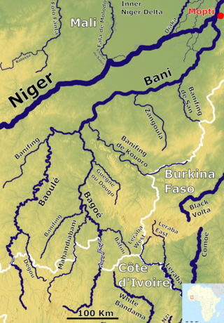
The Bani River is the principal tributary of the Niger River in Mali. The river is formed from the confluence of the Baoulé and Bagoé rivers some 160 km (99 mi) east of Bamako and it merges with the Niger near Mopti. Its length is about 1,100 km (680 mi).

<span class="mw-page-title-main">Mopti</span> Town in the Inner Niger Delta region of Mali

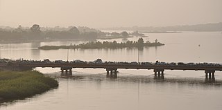
Mopti is a town and an urban commune in the Inner Niger Delta region of Mali. The town is the capital of the Mopti Cercle and the Mopti Region. Situated 630 km northeast of Bamako, the town lies at the confluence of the Niger and the Bani Rivers and is linked by an elevated causeway to the town of Sévaré. The urban commune, which includes both Mopti and Sévaré, had a population of 114,296 in the 2009 census.

<span class="mw-page-title-main">Lake Faguibine</span>

Lake Faguibine was a lake in Mali on the southern edge of the Sahara Desert situated 80 km west of Timbuktu and 75 km north of the Niger River to which it is connected by a system of smaller lakes and channels. In years when the height of the annual flood of the river is sufficient, water flows from the river into the lake. Since the Sahel drought of the 1970s and 1980s the lake has been mostly dry. Water has only rarely reached the lake and even when it has done so, the lake has been only partially filled with water. This has caused a partial collapse of the local ecosystem.

<span class="mw-page-title-main">Massina Empire</span>

The Caliphate of Hamdullahi, commonly known as the Massina empire, was an early nineteenth-century Sunni Muslim caliphate in West Africa centered in the Inner Niger Delta of what is now the Mopti and Ségou Regions of Mali. It was founded by Seku Amadu in 1818 during the Fulani jihads after defeating the Bambara Empire and its allies at the Battle of Noukouma. By 1853, the empire had fallen into decline and was ultimately destroyed by Omar Saidou Tall of Toucouleur.

<span class="mw-page-title-main">Hadejia-Nguru wetlands</span>

The Hadejia-Nguru wetlands in Yobe State in northern Nigeria, which include Nguru Lake, are ecologically and economically important. They are threatened by reduced rainfall in recent years, a growing population and upstream dam construction.

<span class="mw-page-title-main">Waza National Park</span> National park in Cameroon

Waza National Park is a national park in the Department of Logone-et-Chari, in Far North Region, Cameroon. It was founded in 1934 as a hunting reserve, and covers a total of 1,700 km2 (660 sq mi). Waza achieved national park status in 1968, and became a UNESCO biosphere reserve in 1979.

<span class="mw-page-title-main">Niono</span> Commune and town in Segou, Mali

Niono is a town and commune located in the Ségou Region of Mali. The commune has an area of approximately 491 square kilometers and includes the town and 20 of the surrounding villages. In the 2009 census it had a population of 91,554. The town is the capital of the Niono Cercle, one of seven subdivisions (cercles) of the Ségou Region. It lies on the northwest edge of the Inner Niger Delta, near the main channel of the Niger River.

Goundam is a commune and town in north central Mali, in the Tombouctou Region. It is the capital of Goundam Cercle, one of five subdivisions of the Region. In the 2009 census the commune had a population of 16,253. The main ethnic groups are Songhay, Tuareg and Fulani.

<span class="mw-page-title-main">Lake Débo</span>

Lake Débo is a lake in the central part of Mali, formed by the seasonal flooding of the Niger River basin. It is in the Inner Niger Delta of the Niger River. During high water stages of the river, the delta formed by lakes, creeks, and backwaters form part of Lake Débo. The inner delta has many wide channels, which are shallow and flooded marshes; this delta extends over a length of 320 kilometres with a width of 80 km (50 mi). Lake Débo during high flow season, is at a distance of 80 km (50 mi) from Mopti on its upstream, on the southern end and 240 km (150 mi) from Timbuktu at its downstream, on the north-eastern end. It is the largest of many such seasonal wetlands and lakes which form the Inner Niger Delta, and the largest lake within Mali. Its size is largely reduced during the dry season of September to March. The existence of this lake called the "Great Lake" in the inner delta of Niger River between Jenne and Timbuktu in Mali has been established after extensive study of maps of the region extending over a period from 1000 to 1900 AD; 400 maps were studied for the period.

<i>Echinochloa stagnina</i> Species of plant

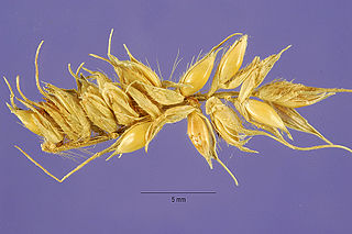
Echinochloa stagnina is a species of Echinochloa widespread in tropical Africa and Asia, with an invasive status in many Pacific islands. It was once one of the major grasses cultivated in the Inner Niger Delta of the Niger River. It was cultivated by the Fulani people, who used the seeds as food, and to make both alcoholic and nonalcoholic beverages.

The wildlife of Mali, composed of its flora and fauna, is widely varying from the Saharan desert zone to the Sahelian east–west zone, to Mali, a landlocked francophone country in North Africa; large swathes of Mali remain unpopulated but has three sub-equal vegetation zones; the country has Sahara Desert in the north, the Niger River Basin at its center and the Senegal River on the south.

Dia () is a small town and seat of the commune of Diaka in the Cercle of Ténenkou in the Mopti Region of southern-central Mali. It is situated at the western edge of the Inland Delta floodplain, and is watered by the Diaka, one of the Niger River's major distributaries and the only permanent watercourse in the region.

<span class="mw-page-title-main">Lake Chad flooded savanna</span> Flooded grassland ecoregion in Africa

The Lake Chad flooded savanna is a flooded grasslands and savannas ecoregion in Africa. It includes the seasonally- and permanently-flooded grasslands and savannas in the basin of Lake Chad in Central Africa, and covers portions of Cameroon, Chad, Niger, and Nigeria.

<i>Vossia cuspidata</i> Species of grass

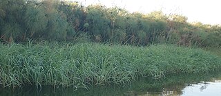
Vossia is a monotypic genus in the grass family, found in Asia and Africa. The only known species is Vossia cuspidata, an aquatic grass native to Africa, and to Assam, Bangladesh, and northern Indochina. The common name is hippo grass.

<span class="mw-page-title-main">Office du Niger</span>

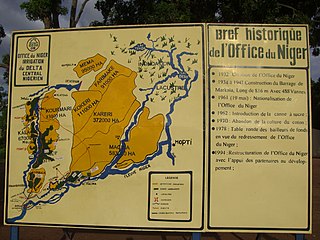
The Office du Niger is a semi-autonomous government agency in Mali that administers a large irrigation scheme in the Ségou Region of the country. Water from the Niger River is diverted into a system of canals at the Markala dam 35 kilometres (22 mi) downstream of Ségou. The water is used to irrigate nearly 100,000 hectares (390 sq mi) of the flat alluvial plains to the north and northeast of Markala that form part of the Delta mort. Although the French colonial administration constructed the system to produce cotton for the textile industry, the main agricultural product is now rice. Around 320,000 tons are grown each year representing 40 percent of the total Malian production. Large quantities of sugar cane are also grown in joint ventures between a Chinese company and the Malian state. The irrigation scheme uses 2.7 km3 (0.65 cu mi) of water each year corresponding to around 10 percent of the total flow of the Niger River.

References

  1. "Delta Intérieur du Niger". Ramsar Sites Information Service. Retrieved 25 April 2018.
  2. Term from Fula : Maasina.
  3. Image Science and Analysis Laboratory, NASA-Johnson Space Center. "The Gateway to Astronaut Photography of Earth." "Figure 4.8". Archived from the original on 2012-07-26. Retrieved 2013-04-17.
  4. 1 2 3 Seiler, R.; Csaplovics, E. (2003), "Monitoring landcover changes of the Niger Inland Delta (Mali) by means of Envisat-MERIS Data" (PDF), in Lacoste, H. (ed.), Proceedings of the MERIS User Workshop, Frascati, Italy, 10 – 13 November 2003[ permanent dead link ].
  5. Briquet, J.P.; Mahe, G.; Bamba, F.; Olivry, J.C. (1996), "Changements climatiques récents et modification du régime hydrologique du fleuve Niger à Koulikoro (Mali)", in Chevallier, P.; Pouyaud, B. (eds.), L'hydrologie tropicale: géoscience et outil pour le développement, IAHS Publ. no. 238 (PDF), pp. 157–166.
  6. LeHouérou, H.N. (1989), The grazing land ecosystem of the African Sahel, Berlin New York: Springer.
  7. Kuberow, H. (1995). Einsatz von Fernerkundungsdaten zur Vegetationsklassifizierung im Südsahel Malis (in German). Berlin, Germany: Köster. ISBN   978-389574081-7.
  8. John, D.M.; Lévêque, C.; Newton, L.E. (1993), "Western Africa", in Whigham, D.; Dykjova, D.; Hejny, S. (eds.), Wetlands of the world 1., Dordrecht, Netherlands: Kluwer Academic, pp. 47–78.
  9. Hughes, R.H.; Hughes, J.S. (1992), A directory of African wetlands, Gland, Switzerland and Cambridge, UK: IUCN, ISBN   2-88032-949-3 .
  10. Elise Martin: Main basse sur le fleuve, Jeune Afrique No. 2583 du 11 au 17 Juillet 2010

Further reading