
The Kariba Dam is a double curvature concrete arch dam in the Kariba Gorge of the Zambezi river basin between Zambia and Zimbabwe. The dam stands 128 metres (420 ft) tall and 579 metres (1,900 ft) long. The dam forms Lake Kariba, which extends for 280 kilometres (170 mi) and holds 185 cubic kilometres (150,000,000 acre⋅ft) of water.

Dartmouth Dam is a large rock-fill embankment dam with an uncontrolled chute spillway across the Mitta Mitta, Gibbo and Dart rivers, the Morass Creek and a number of small tributaries. The dam is located near Mount Bogong in the north-east of the Australian state of Victoria. The dam's purpose includes irrigation, the generation of hydro-electric power, water supply and conservation. The impounded reservoir is called Dartmouth Reservoir, sometimes called Lake Dartmouth. The Dartmouth Power Station, a hydro-electric power station that generates power to the national grid, is located near the dam wall.

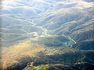
The Eildon Dam is a rock and earth-fill embankment dam with a controlled spillway, located on the Goulburn River between the regional towns of Mansfield and Eildon within Lake Eildon National Park, in the Alpine region of Victoria, Australia. The dam's purpose is for the supply of potable water, irrigation, and the generation of hydroelectricity. The impounded reservoir is called Lake Eildon.The first cut of ground was done by Mr Bain and Mr MacLean from Scotland.

Kainji Lake, in North Central Nigeria, is a reservoir on the Niger River, formed by the Kainji Dam. It was formed in 1968 and is a part of Niger State and Kebbi State. Kainji Lake National Park (KNLP), situated around the lake, is Nigeria's oldest National Park, established in 1976.
Lostock Dam is a minor rockfill and clay core embankment dam with a concrete lined, flip bucket spillway across the Paterson River upstream of the village of East Gresford in the Hunter region of New South Wales, Australia. The dam's purpose includes flood mitigation, irrigation, water supply and conservation. Mini hydro-power facilities were retrofitted in 2010. The impounded reservoir is also called Lostock Dam.

The Blowering Dam is a major ungated rock fill with clay core embankment dam with concrete chute spillway impounding a reservoir under the same name. It is located on the Tumut River upstream of Tumut in the Snowy Mountains region of New South Wales, Australia. Purposes for the dam include flood mitigation, hydro-power, irrigation, water supply and conservation. The dam is part of the Snowy Mountains Scheme, a vast hydroelectricity and irrigation complex constructed in south-east Australia between 1949 and 1974 and now run by Snowy Hydro.
The Shoalhaven Scheme is a dual-purpose water supply and Pumped-storage Hydroelectricity scheme located on the South Coast region of New South Wales, Australia.
The Tumut Hydroelectric Power Stations is a series of three hydroelectric power stations on the Tumut River in New South Wales, Australia, that are part of the Snowy Mountains Scheme.

The Rubicon Hydroelectric Scheme is a small run-of-the-river hydroelectric scheme located on the Rubicon and Royston Rivers, north east of Melbourne, 40 km (25 mi) south-west of Alexandra, Victoria, Australia. The scheme commenced in 1922, and was the first state-owned hydroelectric scheme to generate electricity in mainland Australia, and among the first in the world to be remotely controlled. For the first ten years of its operation it supplied on average 16.9% of electricity generated by the State Electricity Commission of Victoria. It is now owned and operated by AGL Energy and contributes approximately 0.02% of Victoria's energy supply.
The Catagunya Power Station is a run-of-the-river hydroelectric power station located in the Central Highlands region of Tasmania, Australia. The power station is situated on the Lower River Derwent catchment and is owned and operated by Hydro Tasmania.
Pindari Dam is a minor concrete faced rockfill embankment dam with an ungated uncontrolled rock cut with concrete sill spillway across the Severn River located upstream of the town of Ashford, in the North West Slopes region of New South Wales, Australia. The dam's purpose includes flood mitigation, hydro-power, irrigation, water supply and conservation. The impounded reservoir is called Lake Pindari.

The Coleridge Power Station is a hydroelectric facility at Lake Coleridge on the Rakaia River in Canterbury, New Zealand. The power station is owned and operated by Manawa Energy.

Ātiamuri Power Station is a hydroelectric power station on the Waikato River, in the North Island of New Zealand. It is the third of eight hydroelectric power stations on the Waikato River. The station can easily be seen from State Highway 1 between Taupō and Tokoroa.

The Jebba Hydroelectric Power Station, also Jebba Power Station, is a hydroelectric power plant across the Niger River in Nigeria. It has a power generating capacity of 578.4 megawatts, enough to power over 364,000 homes. The plant was commissioned on 13 April 1985, although commercial energy production began in 1983.

The Cahora Bassa Dam is located in Mozambique. It is one of two major dams on the Zambezi river, the other being the Kariba. The project began to come online in 1979 after much political debate. This dam uses the Zambezi River water to generate electricity by turning turbines. That energy is then sent to South Africa. The Cahora Bassa Dam forms Cahora Bassa Lake. The dam is jointly owned by Mozambique and Portugal. From independence until 2007, eighteen percent share of the dam and lake was owned by Mozambique and eighty-two percent by Portugal. Portugal sold down its share to 15 percent in 2007. The Cahora Bassa Dam is the largest hydroelectric power plant in southern Africa and the most efficient power generating station in Mozambique.
The Engineer Souza Dias Dam, formerly known as the Jupiá Dam, is an embankment dam on the Paraná River near Três Lagoas in Mato Grosso do Sul, Brazil. It was constructed for hydroelectric power production, flood control and navigation. Studies on the dam and power plant began in 1951 which recommended the dam along with the Ilha Solteira Dam. The dam was inaugurated in 1968 and its generators were commissioned between 1969 and 1974.
The Baishan Dam is an arch-gravity dam on the Second Songhua River near the town of Baishanzhen, Huadian, Jilin Province, China. The purpose of the dam is hydroelectric power generation and flood control. The dam supplies water to five turbine-generators in two different powerhouses for an installed capacity of 1,500 megawatts (2,000,000 hp) while it can also control a design 19,100 cubic metres per second (670,000 cu ft/s) flood. Additionally, it has a 300 megawatts (400,000 hp) pumped-storage hydroelectric generation capacity. It is named after Baekdu Mountain, near the city of Baishan.
Zungeru Hydroelectric Power Station is a 700 megawatts (940,000 hp) hydroelectric power plant under construction in Niger State, Nigeria. When completed, as expected, it will be the second-largest hydroelectric power station in the country, behind the 760 megawatts (1,020,000 hp) Kainji Hydroelectric Power Station.
The Baynes Hydroelectric Power Station is a planned 600 megawatts (804,613 hp) hydroelectric power plant in northwest Namibia, at the border with Angola.


